Risk Response Actions
Introduction
The Ministry of Water Resources are tasked with the unified management of water resources in China, providing resources for flood control and prevention. Local government water administration departments collectively form the Water Resources Bureau that is responsible for planning and managing water resources (Rubinato et al. 2019). The hierarchy of water management agencies responsible for water resources management is:
- County
- State
- Province and
- City level
Urban flood measures are promoted at all levels. Under the supervision of local government, the Flood Control Office is executive branch responsible for managing floods and reducing impacts, with the State Flood Control and Drought Relief Headquarters in control pluvial flood management (Rubinato et al. 2019).
Flood disaster emergency management mechanism in China includes three aspects (Zhang et al.2020):
1 Pre-disaster prevention and preparation: Major cities in China have basically completed the construction of multi-level protection system. It combines peripheral river embankments, cities main river channel and urban drainage pipe network.
2 Monitoring, forecasting and early warning: Most cities in China have basically established the real-time monitoring system for urban meteorological, hydrological, important water conservancy projects. Urban flood control support platform integrating analysis and decision-making was established. The platform, television, radio, internet, mobile phone SMS and other ways are comprehensively used to issue early warning.
3 Emergency management and on-site disposal: Major cities in China have established specialized and socialized emergency rescue teams by strengthening the mechanism of military and civilian cooperation and regional linkage. It played an important role in urban flood and waterlogging emergency.
In addition, more than 95% cities have completed the flood emergency response plan. Urban flood and waterlogging emergency management have basically formed a legal system combining the national regulations and local regulations (Wang et al. 2014; Zhang et al. 2020).
Water conservation reform has been promoted to allow the improvement of flood protection infrastructure. Also, the sponge city initiative aims to adapt the urban environment to provide water storage, with the recycling of 70% of storm water.
Flood Risk Management in Nanjing
The Risk Response Actions for Nanjing are provided in Figure 1. The System Support items (top panel) can be broadly categorized into (1) the Organization System, which includes human elements in the management of floods, (2) the Engineering System, which relates to infrastructure and (3) the Warning and Emergency System, which comprises aspects of data collection and warning.
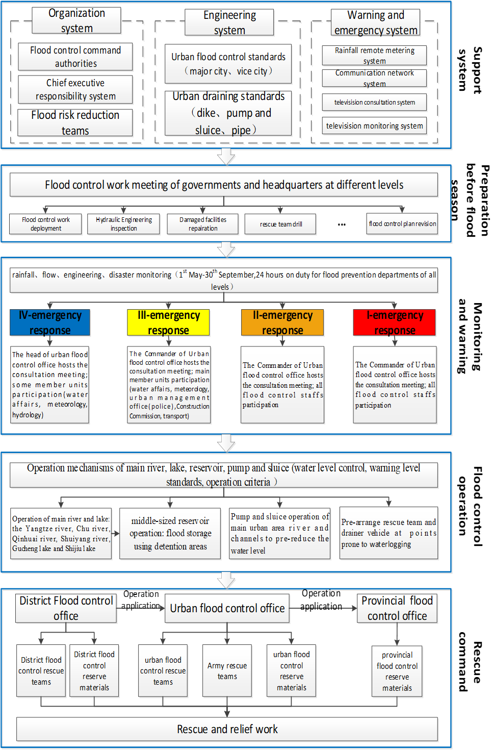
Figure 1. Risk Response Action for Nanjing
There is a proactive aspect to flood management (2nd panel), which involves inspection and repair of flood defences, training of flood rescue teams, and revision of the flood control plan prior to the flood season.
A map of the river system that is monitored for the issuing of flood warnings is provided in Figure 2.
Figure 2. Map of the river system 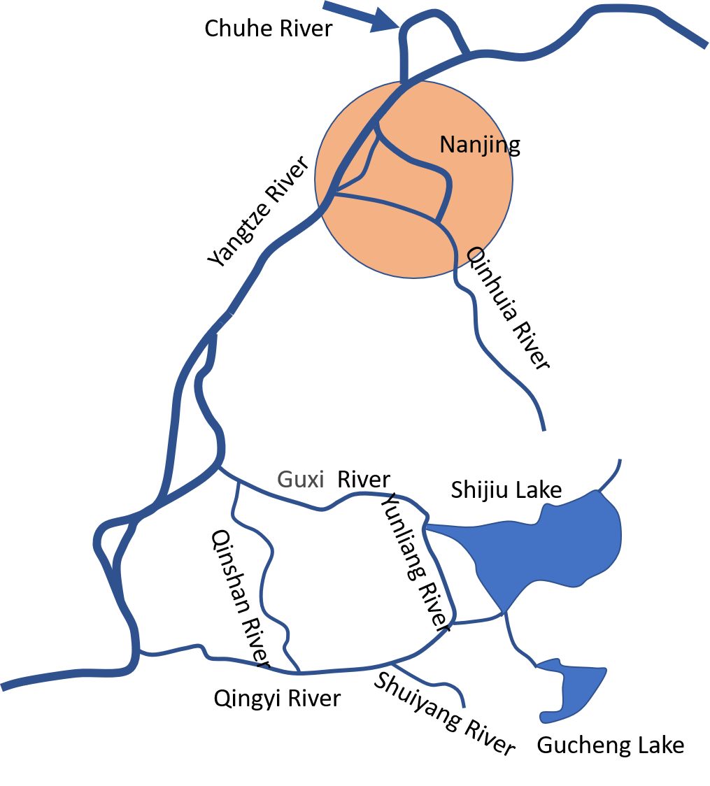
Monitoring and warning activities are in force from May to September, inclusive (3rd panel). The colour-coded rainstorm warning system used in Nanjing comprises:
I level(Red)emergency response when one of the following circumstances occurs:
- Catastrophic flood occur in one of the Yangtze river, Qinhuai river, Chuhe river, Gucheng lake, Shijiu lake; large floods occur in two or more river basins at the same time.
- The 24 hours rainfall reaches 200mm, and it is predicted to continue to rain. Large areas of the main urban areas have water accumulation with severe waterlogging, which had a serious impact on urban production activities and residents' lives.
- The water level of major rivers reaches or exceeds the historical highest water level: the Nanjing high water level of the Yangtze river reaches or exceeds 10.22 meters, the Dongshan water level of the Qinhuai river is higher than 11.17 meters, the Xiaoqiao water level of Chuhe river is higher than 12.63 meters, the Gaochun water level of Gucheng lake is higher than 13.07 meters, and the Sheshan water level of Shijiu lake is higher than 12.68 meters. The flood-affected area of crops exceeds 2 million mu, or the no harvest area exceeds 500,000 mu; Crevasse occur in important river sections of the river and lake trunk stream, and water conservancy projects in the region are in serious danger.
- The collapse appears in medium-sized reservoirs or important small reservoirs.
- The area may be affected by a typhoon or has been affected by a typhoon within 6 hours, with an average wind force above 12.
Ⅱ level (Amber) emergency response when one of the following circumstances occurs:
- Large floods occur in one of the Yangtze river, Chuhe river, Qinhuai river and Shuiyang river.
- The 24 hours rainfall reaches 150mm, and it is predicted to continue to rain. Large areas in the main urban area have water accumulation, which has a great impact on urban production activities and residents' lives.
- Severe floods and waterlogging occur in several districts; The water level of the main rivers is close to or reaches the highest water level in history: the Nanjing high water level of the Yangtze river is 9.50~10.22 meters, the Dongshan water level of the Qinhuai river is 10.00~11.17 meters, the Xiaoqiao water level of Chuhe river is 12.00~12.63 meters, the Gaochun water level of Gucheng lake is 12.50~13.07 meters, and the Sheshan water level of Shijiu lake is 12.00~12.68 meters. The area affected by waterlogging is less than 2 million mu, more than 1 million mu or no harvest area is less than 500 thousand mu, more than 200 thousand mu.
- Rivers, lakes, reservoirs and other water conservancy projects have major risks, such as: watershed water conservancy projects have major risks, small and medium-sized reservoirs have major risks, or small reservoirs collapse.
- The area may or has been affected by a severe tropical storm within 12 hours, with an average wind force of 10~12.
III level (Yellow) emergency response when one of the following circumstances occurs:
- Large floods occur in one of the Yangtze river, Chuhe river, Qinhuai river and Shuiyang river.
- The 24 hours rainfall reaches 100mm and it is predicted to continue to rain. Some places in the main urban area have water accumulation, which affected urban production activities and residents' lives.
- Floods and waterlogging occur simultaneously in several districts, and the water level of major rivers and lakes reaches or exceeds the warning level; Nanjing high water level of the Yangtze river is 9.00~9.50 meters, Dongshan station water level of the Qinhuai river is 9.50~10.00 meters, Xiaoqiao water level of Chuhe river is 11.00~12.00 meters, the Gaochun water level of Gucheng lake is 11.50~12.50 meters, and the Sheshan water level of Shijiu lake is 11.50~12.00 meters. The area affected by waterlogging is more than 500 thousand mu, less than 1 million mu, or no harvest area is more than 50 thousand mu, less than 200 thousand mu.
- Water conservancy projects such as rivers, lakes, and reservoirs are in danger. There is a great danger in watershed engineering facilities and regional engineering facilities; There is serious danger in small and medium-sized reservoirs or dam collapse.
- The area may or has been affected by a tropical storm within 24 hours, with an average wind force of 8~10.
Ⅳ level (Blue) emergency response when one of the following circumstances occurs:
- General level floods occur in several districts at the same time, and the water level of major rivers and lakes reaches the warning level; The high water level of the Yangtze river is 8.50~9.00 meters in Nanjing. The water level of Dongshan station of the Qinhuai river is 8.50~9.50 meters. The water level of Xiaoqiao of Chu river is 9.50~11.00 meters. The water level of Gucheng lake in Gaochun is 10.00~11.50 meters. The water level of Sheshan in Shijiu lake is 10.00~11.50 meters. The area affected by waterlogging is within 500 thousand mu or no harvest area is within 50 thousand mu.
- The 24 hours rainfall reaches 50mm, and it is predicted to continue to rain. Many places in the main urban area have water accumulation.
- Watershed engineering facilities, regional engineering facilities have risk; The Yangtze river embankment appears to slump.
- The general danger appears at reservoirs.
- The area may or has been affected by tropical depression within 24 hours.
A consultation meeting is held on the issue of a rainfall colour-coded forecast, with members of water affairs, meteorology, hydrology, transport and urban managements officers in attendance.
The Flood Control Operation (4th panel) utilizes lakes, reservoirs, pumping stations and sluice gates to control water levels. Figure 3 depicts the pumping stations that protect the Shazhou polder from pluvial flooding.
The Rescue Command (bottom panel) comprises a District, Urban Control Office and a Provincial Control Offices that collectively provide rescue and relief work.
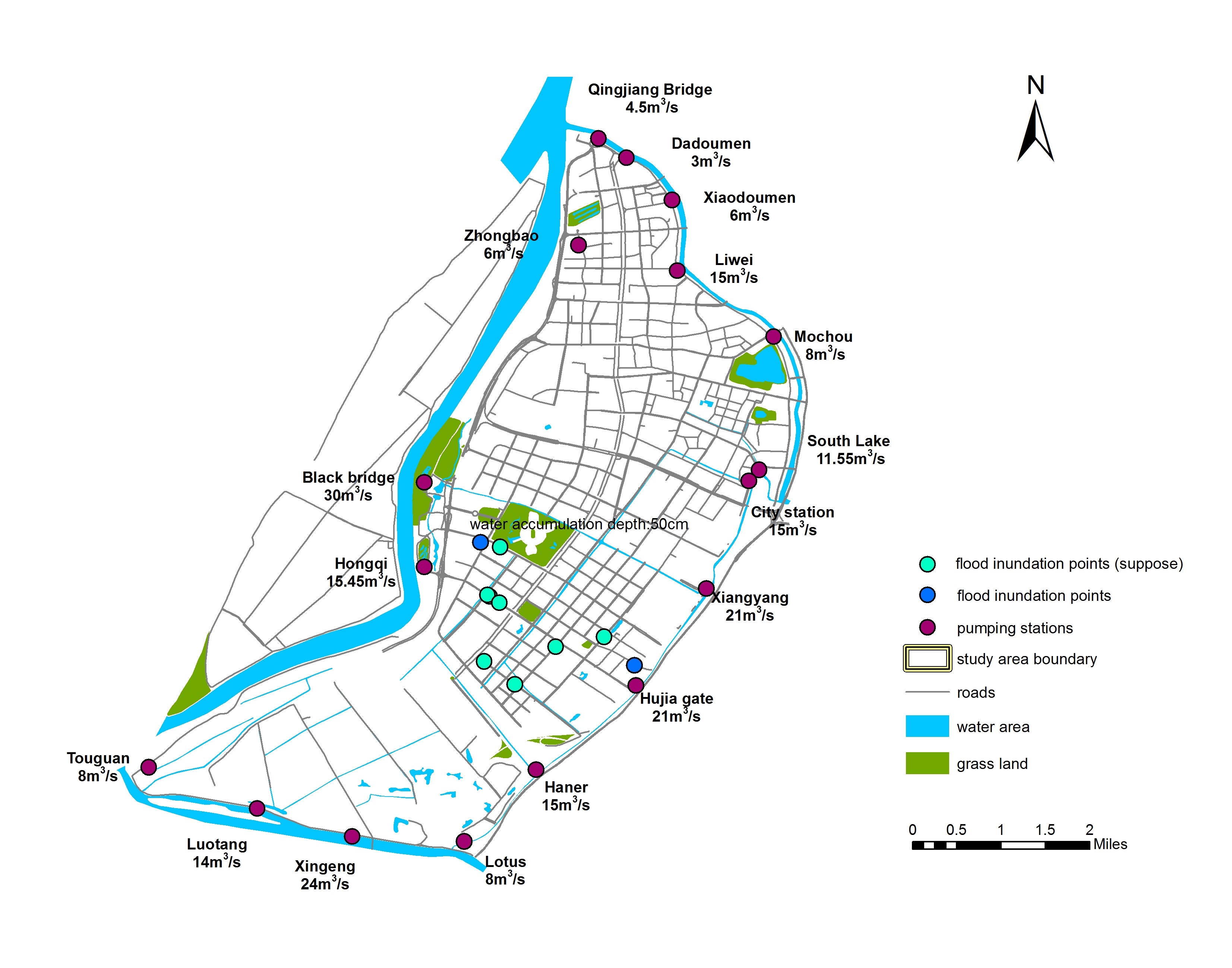
Figure 3. Map of Shazhou polder depicting pumping stations and points of inundation during the July 2016 event
Human Response
Several papers have investigated public response to flooding in Nanjing.
Wang et al (2020) investigated responses during July 2016 flood event using social media and other information. High public concern was found in low lying areas (including Hexi New Town), with public response peaking during, rather than prior, to an event, indicating better preparation is needed. Urban flooding had the largest impact on travel related activities. It was recommended that “policy directions towards a higher level of urban flooding resilience, covering both physical infrastructure and human elements”, are required. Chen et al. (2020) also concluded that pre-disaster preparation does not receive enough attention.
Chen et al (2019) selected sixteen typical waterlogging prone residential areas in Nanjing and constructed flood vulnerability model to discuss the influencing factors of flood vulnerability of urban residents. High flood vulnerability were found in urban residential area with low human capital, older age and lower income. Lower flood vulnerability was found in residential areas with good maintenance, effective government measures and quick property emergency.
References
Chen, Y., Liu, T., Chen, R. and Zhao, M., 2020. Influence of the Built Environment on Community Flood Resilience: Evidence from Nanjing City, China. Sustainability, 12(6), p.2401.
Chen Y., Chen R., Ge Y., et al. 2019. Characteristics and influencing factors of residents’ flood vulnerability in Nanjing Urban residential area. Journal of Catastrophology, 34( 1) : 56-61. (in Chinese)
Rubinato, M., Nichols, A., Peng, Y., Zhang, J.M., Lashford, C., Cai, Y.P., Lin, P.Z. and Tait, S., 2019. Urban and river flooding: Comparison of flood risk management approaches in the UK and China and an assessment of future knowledge needs. Water Science and Engineering, 12(4), pp.274-283.
Wang, B., Loo, B.P., Zhen, F. and Xi, G., 2020. Urban resilience from the lens of social media data: Responses to urban flooding in Nanjing, China. Cities, 106, p.102884.
Wang X., Zhao P., 2014. Emergency management of flood in cities of China: Progress and measures. China Water Resources.(1),28-30. (in Chinese)
Zhang N., Li N., Wang Y., Ding Z., Yu X., 2020. Discussion on the framework of urban flood hazard emergency management in China. China Flood & Drought Management, 30(7): 5-9, 77. (in Chinese)