Historical Images
This gallery of historical images provides geographical and visual context to Blyth’s industrial past that can help us to think about the future. The images hopefully will trigger memories and other responses about how coastal communities such as Blyth have changed.
We thank the following institutions for their assistance and use of their images: The British Library, Durham Mining Museum, National Library of Scotland, Port of Blyth Archives, Tyne and Wear Archives.
(Image of damaged billboard with painting of Blyth river. Photography by Clifton Evers)

1787 COLLIERIES MAP
Author: Gibson, J. 1787. Portion of the map reproduced with permission of the British Library.
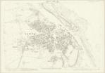
Ordnance Survey Map
Map reproduced with permission of the National Library of Scotland.

Blyth Harbour
Taken by Turners, Northumberland St. Newcastle upon Tyne. Ref. 4523A.
Blyth Harbour Negative 27968C
Reproduced with permission of the Port of Blyth Archives.
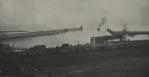
Construction of East Pier, Blyth
Reproduced with permission of the Port of Blyth Archives.
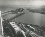
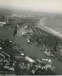
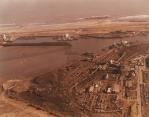
Aerial Photograph Blyth Harbour
Reproduced with permission of the Port of Blyth Archives.
Photograph of the Port of Blyth
Reproduced with permission of the Port of Blyth Archives.

Photograph of Loading Scrap Metal Blyth Harbour
Reproduced with permission of the Port of Blyth Archives.