![]()
|
|
|
|
Case Study 1 - Land-Use Change and Flood Risk
BackgroundThe 26 km2 Dunsop catchment in the Forest of Bowland is a tributary of the Hodder and Ribble. Large-scale changes are being made to the land-use/management, giving an almost unique opportunity to analyse the effects on local and downstream flood risk. The changes being made include woodland planting, blocking of moorland grips, changes in stocking density, and changes in bracken burning policy, all with the aim of preventing further deterioration of the raw water quality and improvement of the condition of the SSSI areas. Preliminary SHETRAN simulations have been carried out for the site.
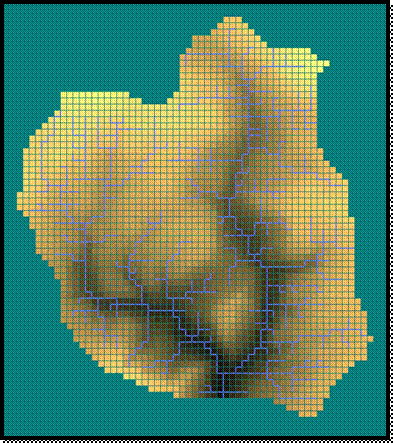
SHETRAN ModelA SHETRAN model with a 100m grid size was set-up for the catchment. There were several stages to this. Firstly, a50m DEM was extracted for the site using Digimap. Then in ArcMap the following procedures were carried out. Firstly the DEM was converted into a 100m DEM. Then using the 100m DEM and the position of the outlet the grid squares within the catchment (catchment mask) were calculated. Both DEM and catchment Mask were then both output in ASCII format. Then using Shetran Windows (without the 36 x 36 restriction) the SHETRAN model was set-up. This automatically sets up the stream network, in this case assuming a stream exists if the upstream contributing area is greater than 4 ha (0.04 km2). Finally there was some calibration of the soil and overland flow roughness parameters. This preliminary model was run for 3 years from 2003-2005 using 15 minute precipitation data and daily potential evaporation data.
100m DEM and Catchment Mask
SHETRAN catchment and stream network
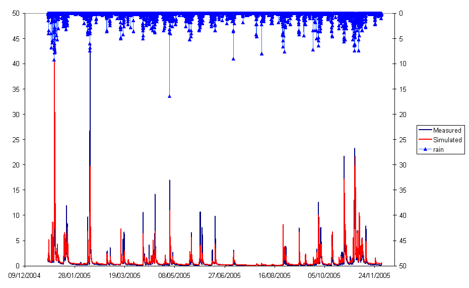
ResultsThe comparison between the simulated and measured discharge for 2005 can be seen below for the preliminary simulations. Work is continuing on these simulations particular looking at the event in February 2005. This includes looking at the spatial distribution of rainfall using radar data. Work is also continuing on visualisation of the data using a WKML library developed by Gen-Tao Chiang. Click here to view some figures extracted from Google Earth.
|
|
Send mail to
s.j.birkinshaw@ncl.ac.uk with
questions or comments about this web site.
|