Environmental Informatics
We have unparalleled experience and expertise in the field of environmental informatics, notably in the establishment of urban and rural observatories at multiple scales, data processing, high performance computing, consideration of the interaction between people and information, the development of interfaces and decision support systems. We here build on our ‘pump priming’ NERC CDT on ‘Big Data, Environmental Risk and Modelling’ and experience of delivering multidisciplinary training around environmental systems, big data, computing and advanced modelling/analytics.
We collect and use observed data to inform understanding, from:
- observatories and state-of-the-art facilities
- big data
- interactions: communities, data & decision support
Available Environmental Informatics studentships can be found here
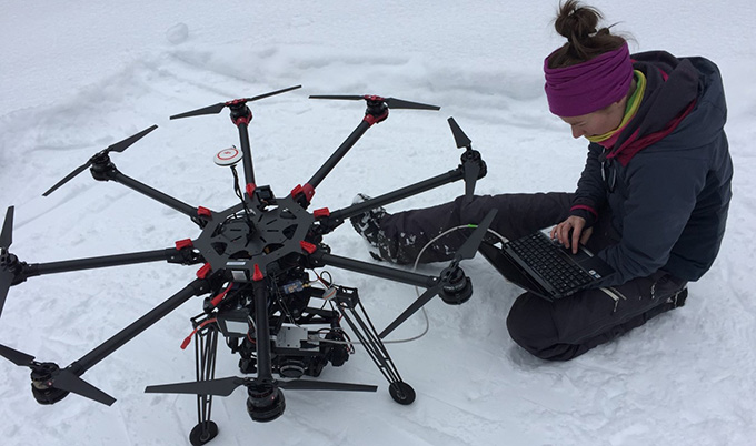
Observatories and state-of-the-art facilities
Cutting-edge infrastructure, facilities and unrivalled expertise underpin the research training provided to our students. Newcastle University have a record of multidisciplinary research underpinned by large-scale observation, application of modern analytical/modelling approaches and high performance computing. Our equipment pool includes significant investment in long-term and heavily instrumented monitoring sites, e.g. Eden Demonstration Test Catchment, A38 monitored embankment, and two university farms; state-of-the-art laboratories, e.g. Newcastle University marine trace gas biogeochemistry and marine biological laboratories (Ridley Building and Dove Marine), Northumbria’s Multi-Omics laboratories and DNA sequencing service, Northumbria’s Environmental Sciences Laboratories (with isotope ratio mass spectrometer, elemental analyser, etc.), Marine Research Station in Blyth with a coastal vessel used for both education and research, the North East Satellite Applications Catapult Centre of Excellence providing access to satellite technology, and our Observatories:
- Newcastle Earth Observation laboratory (NEOlab): resource for methodological development and application of remote sensing, photogrammetry and laser scanning for enhanced mapping, monitoring and modelling of the natural environment at multiple scales, including spaceborne InSAR, GBSAR terrestrial, mobile and UAV-based laser scanning, image capture and advanced computing and data visualization facilities.
- Newcastle's Urban Observatory: provides the UK's largest set of real-time data on the urban environment (weather, air quality, water, etc.) by collecting/managing >1Bn data points from multiple sensors at locations across Newcastle (~1M observations/d). Two flux towers in Newcastle simultaneously monitor carbon/air pollution fluxes at urban and rural sites.
- National Green Infrastructure Facility: a component of the UK Collaboratorium for Research on Infrastructure and Cities, it is a ‘living lab’ for pioneering solutions to global challenges in water and sub-surface behaviour for urban sustainability.
Big Data
A Newcastle University, strong links across mathematics, computation and statistics provide extensive and diverse big data and computing modelling capabilities, supported by the University-wide high-performance-computing facility ‘Rocket’, consisting of over 5000 cores and 500TB storage. We use Big Data across our research portfolio, from climate change research into high-resolution convection-permitting modelling, hydrological cycle changes, hydrological mass transfers, through to geohazards. We routinely use advanced geospatial data capture, management, analysis and modelling to manage and analyse ‘Big Data’ from our observatories. We employ massive heterogeneous sensor networks for real time analysis of cities, using crowd-sourced data (e.g. twitter feeds) to parameterise, in real-time, GPU-based flood models. Big Data management also plays a critical role in climate risk analysis; utilising terabytes of RCM outputs. Our standing in high performance computing, in particular cloud computing and Big Data, is recognised by our EPSRC CDT in ‘Cloud Computing for Big Data’ at the Cloud Innovation Centre, while our Digital Institute provides advanced ‘CAVE’ decision support and visualisation environments with training modules suitable for DTP students.
Interactions: communities, data & decision support
We have strong roots in community-based research, integrating independent sources of information from hydrological 'citizen science' and remote sensing to address data scarcity issues, improving community-based earthquake disaster risk reduction and adaptive management of groundwater for small-scale irrigation. Our Decision Support Matrix (DSM) approach generates visualisation and communication tools that help solve environmental issues, applied successfully to problems such as nutrient export from farming, flooding in farmed landscapes and soil erosion. Our statisticians have expertise in modelling and predicting a range of extreme environmental events, providing a framework for decision making and planning from observational data. Many of the scientific evidence needs for policy, e.g. data for licensing of offshore renewables, impacts of dredging for aggregates, etc., can be addressed in Newcastle University’s unique Policy Academy. In addition, Newcastle University’s Decision Theatre is an interactive 3D facility that provides researchers and a range of stakeholders with data visualisation for collaborative decision making. DTP students will also have access to expertise from Open Lab, a human-computer interaction, social and ubiquitous computing research group in the School of Computing. It has particular expertise in the configuration and conduct of cross-disciplinary research and application of digital technologies to real-world problems.