Next time
The simplest and easiest thing you can do to help us next time there's urban flooding in Tyne and Wear, is to let us know about it. This is very easily done if you have a Twitter account. If you don't, it only takes a minute if you fill in your details on this page.
Letting us know somewhere has flooded
You need to send a Tweet which our system will recognise. The most valuable information to us is a location and a depth, so as an example
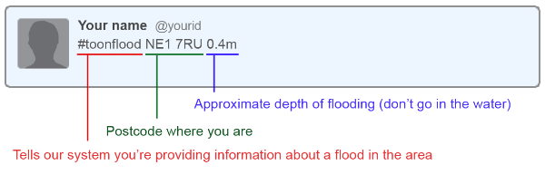
The above Tweet would allow us to automatically identify the location of the flooding using the postcode, usually to within approximately 100m. You can also include a photo if you've taken one; our systems can't process these automatically but they will help us identify how accurate the system was after an event.
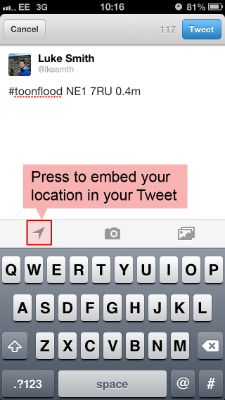 Enabling geolocation in Tweets on a mobile phone
It's even more helpful if you can provide an accurate location by Tweeting from a smartphone which has built-in GPS. Most modern smartphones can embed your location in a Tweet, but often this functionality is disabled. In the UK fewer than 2% of Twitter users are thought to have geolocations enabled in their Twitter app.
Within the Twitter app on your mobile phone, when composing your Tweet, you should press the location icon to attach your GPS coordinates or a location determined by your Wi-Fi network to the message.
When enabling this function you may have to answer some additional questions to allow your mobile phone to provide this data to the Twitter app.
Check the location shown on the map is close to where you actually are. If you're tweeting from a different location to where the flooding was, then please disable embedding your location and use a postcode instead.
Once you have sent the Tweet describing the location of flooding, you can disable the functionality again by pressing 'stop sharing' on the map.