July 2021
How can three-dimensional seismic data help development of low-carbon technologies?
Alex Dickinson, Hector Barnett and Mark Ireland explain the importance of seismic imaging in planning subsurface energy projects.
Use of hydrogen fuel and removal of carbon dioxide from the atmosphere will be key to decarbonisation of the UK economy. Clean hydrogen will power heating and transport, whilst removal of atmospheric carbon can compensate for unavoidable industrial emissions. To realise these technologies, large volumes of both hydrogen and carbon dioxide must be stored safely for long periods of time.
One promising method of storage involves injecting hydrogen or carbon dioxide into cavities within rocks buried hundreds of metres beneath the land surface. Tests at several locations, including in the North Sea, have demonstrated that subsurface storage is safe and effective. Further development of such storage beneath the British Isles and its surrounding seas now depends on detailed understanding of three-dimensional geological structure.
This understanding can be gained using seismic imaging, which is carried out using seismic waves that are generated by machinery at the ground surface. These waves travel downwards and interact with features such as geological strata, fluid-filled reservoirs, and faults. Some waves are reflected towards the Earth’s surface, where they are detected by a system of recording devices. Careful analysis of these reflected waves yields images of subsurface structure. By repeating this process at many different locations, three-dimensional maps can be built.
The Newcastle Energy Geosciences group uses existing three-dimensional seismic images for a range of projects. One such project is exploring the possibility of storing hydrogen or carbon dioxide within salt-filled caverns beneath the North Sea. Using an impressive catalogue of seismic data that has been acquired over several decades for hydrocarbon exploration and mineral mapping, we construct detailed three-dimensional models of subsurface stratigraphy in order to identify potential sites for underground storage.
The situation beneath the British Isles is far less encouraging. Only approximately 1% of the land area of the United Kingdom has been mapped by three-dimensional seismic surveys. Acquisition of new data using industry-standard equipment is hampered by high costs and the logistical difficulty of deploying long electrical cables in urban environments. To develop an alternative approach, we have been collaborating with start-up company STRYDE to explore the potential of their ground-breaking lightweight seismic recording system. Initial tests were undertaken at the Newcastle Helix site in autumn 2020. In autumn 2021, we plan to begin detailed surveying at a major industrial site. Using the results of this survey, we will assess how geothermal energy can help lower the carbon footprint of on-site heating systems.
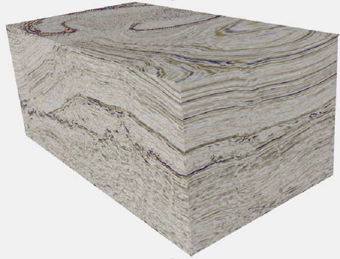
Figure 1. Visualisation of three-dimensional seismic data beneath the southern North Sea. The cube has a length of 20 km, a width of 10 km and a depth of approximately 1.8 km. Bright red and blue colours show geological features that strongly reflect seismic waves. Patterns within the cube show slumping of rock around a large salt-filled cavern, which could potentially be used to store hydrogen or carbon dioxide. Data originally acquired by PGS ASA and downloaded from the UK Oil and Gas Authority National Data Repository.