Digital Soil Mapping
Multitemporal Soil Pattern Analysis (MSPA)
For precision agriculture, qualitative and quantitative soil data at multiple scales are important to optimise the farm inputs to the presence of spatiotemporal within-field variability of soil characteristics. High-temporal, high-spatial resolution multispectral satellite imagery and time series offer great potential for soil information extraction, derivation of soil patterns, and mapping of site-specific management zones and soil surface units. The common problem of monotemporal analysis with a single satellite image is the existence of heterogeneous spatial reflectance patterns due to the different land uses and vegetation conditions. This means, static/stable soil reflectance patterns persist aside from temporal patterns caused by crop types, vegetation phenology and field management practices.
To reduce the disturbance of the temporal patterns, the cost-efficient Multitemporal Soil Pattern Analysis (MSPA) method using multispectral satellite image time series makes it possible to i) separate the static soil pattern from the temporal pattern, ii) identify most suitable bare soil images, and iii) evaluate the spatiotemporal variability of the soil reflectance pattern (soil brightness pattern). This enables the generation of functional soil maps at the field and the multiple-field landscape scale based on the relationship between spatiotemporal static soil reflectance pattern of bare soil images and the responsible soil parameter [Blasch et al. 2015ab].
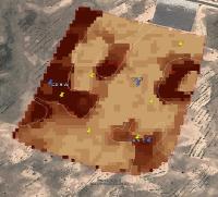
In this study, the feasibility of the MSPA method is evaluated at croplands in China and UK with the main objective to provide functional soil maps for site-specific management to the Agri-Tech industry. Therefore, multispectral satellite imagery such as RapidEye, Gaofen-2 and Sentinel-2 are tested. For the UK, our Agri-Tech industry partners AgSpace and Courtyard Agriculture offer similar field management products based on soil brightness scans. The figure shows a basic soil map at a 5.5-ha demonstration field of Yangshucaideng Farm (China), composed of soil brightness pattern, delineated soil management zones, and soil sampling locations (source: AgSpace, Courtyard Agriculture).
- Blasch, G., Spengler, D., Hohmann, C., Neumann, C., Itzerott, S., Kaufmann, H. (2015a). Multitemporal soil pattern analysis with multispectral remote sensing data at the field-scale. Computers and Electronics in Agriculture, 113 , 1–13.
- Blasch, G., Spengler, D., Itzerott, S., Wessolek, G. (2015b). Organic matter modelling at the landscape scale based on multitemporal soil pattern analysis using RapidEye data. Remote Sensing, 7, 11125-11150.
Last modified: Mon, 29 Feb 2016 15:15:34 GMT