
Eskdale
Introduction
An extensive upland common, Eskdale hosts four SSSIs and lies within the Lake District National Park. Common land is integral to landscape and land use in the Lake District: the modern county of Cumbria contains the largest area of common land of any county in England (some 112,786 ha), and Eskdale is one of the largest commons in the county, consisting of over 3000 ha. Together with providing an important agricultural resource for the local hill farming community, and a conservation landscape, Eskdale is a popular tourist destination – the setting for some of the Lake District’s most famous walks and climbs. Scafell Pike, England’s highest mountain, lies on the periphery of the case study area.
Background
Common land registration number: 58
Hectares (approximate): 3071.5 ha
Landscape type: upland
Landowner: The National Trust
Local management: Eskdale Commoners Association
Statutory designations: Lake District National Park, SSSI, Special Area of Conservation
Common rights: pasture, turbary (peat and turves), estovers (e.g. bracken)
Stocking traditions: levancy and couchancy, heafing
Historical Context
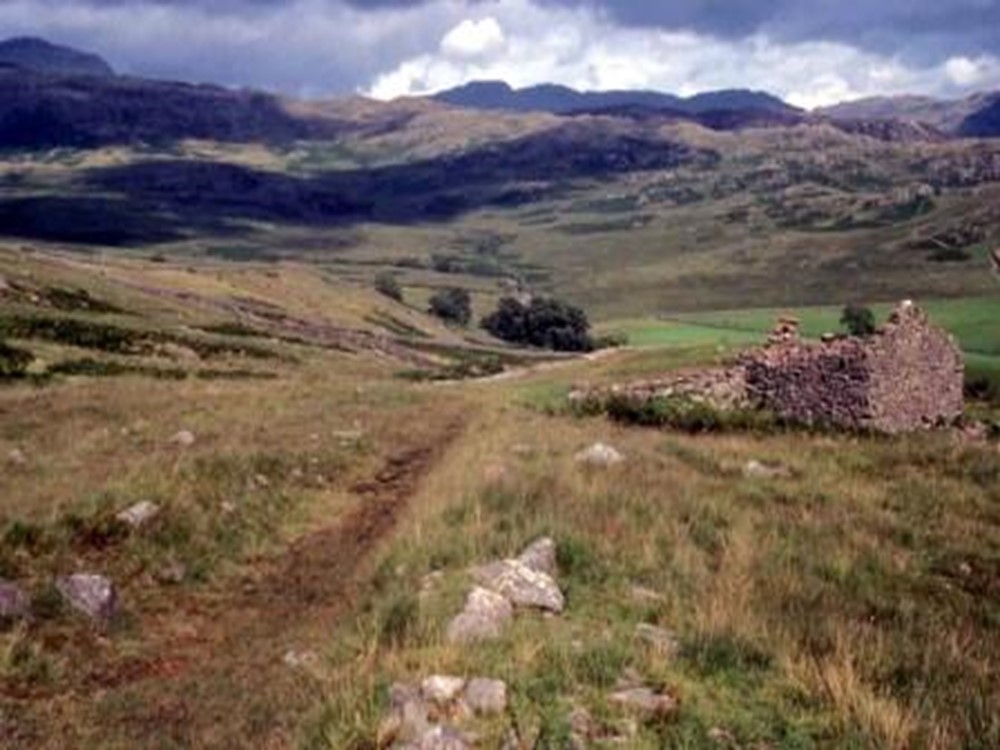
Historically, this large common provided the community with a wide range of essential resources and materials – products such as pasture, peat, and bracken – and was the cornerstone of the pastoral economy. From the medieval period to the early nineteenth century exercise of common rights was regulated by the manor court of Eskdale, Miterdale and Wasdalehead, with a jury of local customary tenants making and enforcing agrarian rules (read more about the manor court in our Historical Briefing Paper). By the mid nineteenth century the manor court had largely withdrawn from common land affairs and the common entered a long period without a management institution; then, in the late twentieth century, a new body was formed – the Eskdale Commoners Association – which continues to look after the common today. Documentary evidence such as manor court records, estate papers and minute books give us rare insight into common land use and management in Eskdale over long periods of time. The landscape itself also provides evidence of land use practices and land use change, as can be seen in the range of historic structures still present in the landscape – from the disused peat huts and grouse butts, to the remote keeper’s lodge beside Burnmoor Tarn.
The principal common rights and resources associated with the common are outlined below:
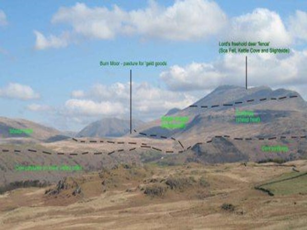
Pasture: grazing for sheep, cattle and horses. The topography of the common varies greatly, with different areas playing different roles in the pastoral system. Historically, the more fertile and sheltered slopes immediately above the valley farms were used as cow pastures; the large area of open grazing around Burnmoor Tarn was used as summer pasture for horses and cattle; the rougher fells above were used for sheep; and a specific area was designated as the Lord’s freehold deer ‘fence’ – see image, right (click on image for larger version). Today all areas of the common are grazed by sheep, though some cattle are being reintroduced. Eskdale has a continuing tradition of ‘hefted’ flocks, whereby a farm’s flock is associated with a particular ‘heaf’ or area of the fell. Rules of access to pasture on Burnmoor and the location of each farm’s heaf and drift (designated route onto the common) were confirmed in a document of 1587 known as the ‘Eskdale Twenty-Four Book’ (so-called because it was drawn up by a jury of twenty-four men). For a map of the different grazing areas set out in the 1587 award, follow this link: Map of Pasture Rights, 1587 (map first published in Angus J. L. Winchester, Landscape and Society in Medieval Cumbria, Edinburgh: John Donald, 1987). Historically, stocking numbers on the common were determined by the manorial rule of ‘levancy and couchancy’: graziers could put no more animals on the common than they could maintain through the winter on their in-bye land. For more information see our Historical Briefing Paper.
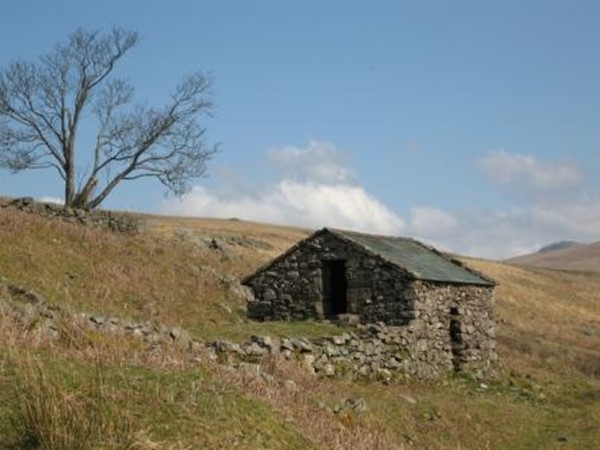
Peat: fuel. Peat was once the main source of domestic fuel in Eskdale, and access to the peat mosses was carefully regulated by the manor court. In certain periods the court appointed special officers, ‘peat moss lookers’, to oversee peat cutting and report anybody contravening rules of access. Today, disused peat huts, known locally as ‘peat scales’, can still be seen on the common. Each hut would have been used by a specific holding as a place for drying and storing peats. Peat cutting continued in Eskdale into the middle of the twentieth century. For more information see our Historical Briefing Paper and Angus Winchester’s paper ‘Peat storage huts in Eskdale’ (published in Transactions of the Cumberland & Westmorland Antiquarian & Archaeological Society, new ser. 84 (1984), pp. 103-115).
Bracken: thatch, animal bedding, and potash. Over time, concentration on sheep and the loss of heavier grazing animals, such as cattle and horses, has allowed bracken to dominate areas of common in the Lake District and it now presents problems for conservation and land management. But bracken was once an essential and carefully managed resource: it provided roofing materials, litter for animals (important in an area of limited arable production), and through burning could be turned into a valuable fertiliser – potash. Eskdale farmers continued to cut bracken for animal bedding up to the middle of the twentieth century. For more information see our Historical Briefing Paper and Angus Winchester’s paper ‘Village byelaws and the management of a contested common resource: bracken (Pteridium aquilinum) in highland Britain, 1500-1800′ (published online by the Digital Library of the Commons, 2006).
Briefing papers
The following briefing papers present the historical data gathered so far on common land in this case study area. Papers will be revised and expanded during the course of the project. The accompanying map shows manorial boundaries and common land:
Eskdale Case Study: Historical Briefing Paper PDF 205Kb
Eleanor Straughton and Angus Winchester, Working paper (new revised version: September 2008)
The following papers comprise reports on qualitative research conducted in the case study area, looking at common land registers, environmental governance, property rights and land management issues. The research process included stakeholder interviews, focus groups, and literature reviews:
Eskdale Qualitative Research Analysis PDF 463Kb
Pieraccini, Margherita, Working Paper (revised draft - November 2009)
Analysis of Eskdale Common Land Register PDF 160Kb
Rodgers, Chris, Working Paper (January 2010)
Background Papers
The following paper, first published in 1984, is reproduced here with the kind permission of the Cumberland & Westmorland Antiquarian & Archaeological Society:
Peat storage huts in Eskdale PDF 1,922Kb
Wincester, Angus, J. L. (1984), Transactions of the Cumberland & Westmorland Antiquarian & Archaeological Society, new ser. 84, pp.103-115