
ROSES STUDY SITES
The ROSES study sites have been chosen to be represent the diverse settings of gypsum dissolution in found in Europe.
These comprise:
The emphasis placed on ground conditions e.g. geology, geomorphology, hydrogeology etc. varies between sites. For example, the arid environment of northern Spain which lacks significant vegetation cover, and is devoid of thick Quaternary deposits overlying the evaporites (characteristic of sites in the UK and Ukraine), provides the ideal opportunity for a geomorphological investigation of evaporite dissolution. The UK Sites are generally covered in deposits of glacial till so an investigation of geomorphology would not yield the wealth of data obtainable in northern Spain. However, the available data provide the conditions for an investigation taking much greater cognisance of the hydrogeology.
UK Study Sites
The area under investigation around Ripon is associated with the floodplain of the River Ure, and closely neighbouring areas, comprising an area of approximately 5km long and 5km wide . This is the most severely affected by subsidence related to gypsum dissolution, but the problem extends over a much larger area.
Ripon has the worst gypsum related subsidence in England. At least 30 major collapses have occurred in the last 150 years. The subsidence features, which are associated with the underlying gypsum, are commonly 10-30m in diameter and reach up to 20m in depth. To the east of the city, a collapse sinkhole in the Sherwood Sandstone is 80m in diameter and 30m deep. The gypsum occurs in a belt about 3km wide and is bounded to the west by the base of the lowest gypsum unit (at the bottom of the Edlington Formation). To the east the belt is limited by the down dip transition from gypsum to anhydrite in the upper gypsum bearing unit in the Roxby Formation. The spatial distribution of subsidence features within the subsidence belt relates to the joint azimuths in the bedrock, the cave and subsidence pattern follows the joints (Cooper, 1986). The highest density of subsidence features is along the sides of the buried Ure valley where the artesian water escapes from the gypsum sequence. However, the apparent density of subsidence hollows is lower on the present river flood plain owing to the hollows being constantly filled with over-bank flood deposits.

The Geological sequence beneath Ripon comprises Upper Permian dolomitic limestones, evaporites (two distinct layers of gypsum), mudstones and marls overlain by the Sherwood (Triassic) Sandstone. This sequence is overlain by Quaternary deposits comprising till (boulder clay), sands and gravels.
The main geomorphological components of the Ripon area include, the expression of the geological units, the depth and morphology of the buried valley beneath the River Ure and the nature and distribution of subsidence hollows and foundered strata.
The present River Ure is a misfit river whose antecendent, the much larger proto-Ure cut down through the bed rock during the Pleistocene, to a depth of about 30m below the present floodplain. This proto-Ure valley is critical in the development of subsidence around Ripon.
Cooper (1998) illustrated 16 sinkhole variations in the subsidence belt at Ripon, these fall within the entrenched, subjacent and mantled karst types identified in the study of conceptual settings. These variations are caused by a number of variables including; the type of gypsum karst, the nature and thickness of the overlying deposits, presence of solid rock overlying the gypsum and the size of voids in gypsum. To the west of the Ripon, The Edlington Formation lies directly beneath the drift deposits. Therefore the marl unit and drift deposits above gradually subside into the pinnacled karst developing in the gypsum (this situation is analogous to mantled karst). Between the city and the River Ure, the limestone of the Brotherton Formation overlies the Edlington Formation. The karst developed comprises caves in the gypsum which have migrated up through the overlying rock to form features known as breccia pipes. The gypsum karst is analogous to entrenched karst. A similar situation is represented to the East of the River but two karstified gypsum units are involved i.e. the Edlington and the Roxby formations.
Hydrology
The area of Ripon experiences a mean annual rainfall of 680mm with mean monthly maxima and minima of 67mm and 48mm during January and July respectively (period from 1961-1990, UK Meteorological Office data). The overland flow is concentrated into the River Ure, which is fed from the west by the River Skell, which runs through the centre of Ripon, and its tributary the River Laver. These rivers rise on the Carboniferous strata that comprise the high ground of the Eastern Pennines. Their hydrographs in 1992 (Figure 3.3) show a base level indicating that the rivers receive a groundwater flow throughout the year. Data from Westwick Lock (National Grid Reference SE 356 671) for the period October 1959 -December 1990, showed mean monthly flow of 20.67 m3s-1 with maxima and minima of 27.066 and 12.946 m3s-1 respectively.
Hydrogeology
Thompson et al. (1996) recognised four hydrogeological units in the Ripon area:
In the Ripon area, the local base level is controlled by the River Ure. The buried valley of the proto-Ure, filled with permeable sands and gravels, is a major influence on the local hydrogeology (Cooper 1986, 1998). It cuts down to the Cadeby Formation beneath the River Ure providing a connection or pathway between all four aquifer units and the River Ure. Cooper (1997) noted considerable groundwater flow along this route with artesian sulphate-rich water issuing from the Permian strata into the Quaternary gravels of the buried valley and then passing into the River Ure. Cooper (1986, 1995) reported that the buried valley gravels are cemented with calcite. This was precipitated as a result of the common ion (Ca2+) effect in the calcite-gypsum aqueous system, it further confirms the flow of water upwards through the gypsiferous strata. The elements of the hydrogeological system, important in gypsum dissolution are summarised as follows. Precipitation falling on the high ground of the Cadeby formation to the west and the Sherwood Sandstone to the east travels down towards the Ure valley. The ground water becomes largely confined beneath glacial till deposits but finds an exit to the river Ure via the deeply incised sand and gravel filled valley of the proto-Ure. It is this pathway which allows water to be forced upwards through the gypsum units of the Edlington and Roxby Formations, causing gypsum dissolution. Sulphate rich water is then discharge through springs in the base of the river and on the valley sides.
Active Subsidence
Around Ripon a subsidence event occurs approximately every year (Cooper, 1995) with areas adjacent to the Ure experiencing the greatest frequency of events. In the built up area of Ripon, however, a collapse occurs about once every ten years (Cooper, 1997).
One of the more recently documented examples is of the subsidence crater which opened up in front of a house on Ure Bank terrace on 23rd and 24th April, 1997 (Figure, 3.4). Cooper documented this event as follows.
 "The hole
grew in size and migrated towards the house, to measure 10m in diameter and
5.5m deep by the end of Thursday. Four garages have been destroyed by the
subsidence. This collapse was the largest of one of a series that have affected
this site for more than 30 years. The hole is cylindrical but will ultimately
fail to become larger, but conical, depression. As it does so, it may cause
collapse of the house, which is already damaged, and the adjacent road. The
house and several nearby properties have been evacuated, the road has been
closed. The gas and other services, which run close to the hole, have also
been disconnected in case of further collapse."
"The hole
grew in size and migrated towards the house, to measure 10m in diameter and
5.5m deep by the end of Thursday. Four garages have been destroyed by the
subsidence. This collapse was the largest of one of a series that have affected
this site for more than 30 years. The hole is cylindrical but will ultimately
fail to become larger, but conical, depression. As it does so, it may cause
collapse of the house, which is already damaged, and the adjacent road. The
house and several nearby properties have been evacuated, the road has been
closed. The gas and other services, which run close to the hole, have also
been disconnected in case of further collapse."
Darlington lies on gently undulating terrain situated approximately 4km north of the River Tees in County Durham. Parkside, a housing development on the southern side of the town, has been selected for detailed investigation. It comprises an area of 2km by 1.5km east of the River Skerne which flows through Darlington town centre.
Geomorphology
The study area comprises a generally flat landscape developed on Quaternary till with an elevation of around 40 to 43m. The River Skerne (Figure 3.5) flows southwards through the centre of Darlington to join the Tees 4km to the south. The land surface rises to the north and west gradually passing into the Pennine hills in the west. The maximum altitude of groundwater recharge is about 130m where Permian limestones are covered by a thin deposits of drift..
Geological maps of the Darlington area show two types of closed surface depressions. The most numerous are closed shallow depressions which attain diameters of up to 100m and occur beyond the northern, eastern and southern fringes of the town. To the South of Darlington, a cluster of sinkholes known as Hells Kettles were formed during a collapse in 1179. In his description of the features, Longstaffe (1854) quoted a twelfth century annalist thus:
"In the reign of Henry II, the earth rose high at Oxendale, in the District of Darlington, (Oxendale is now Oxney flat) in the likeness of a lofty tower, and so remained from nine in the morning until evening, when it sank don with a terrible noise, to the terror of all that heard it, and being swallowed up it left behind a deep pit"
The sinkholes are fed by artesian water and have been designated a Site of Special Scientific Interest (SSSI) for their ability to support a hard water "fen" flora .
Geology
The Geological sequence beneath Darlington comprises Carboniferous strata unconformably overlain by Permian limestones, gypsum, marls and mudstones, overlain by a thick deposit of Quaternary glacial till. Prior to the investigations described below, knowledge of the geology was limited to that shown on 1:50,000 BRITISH GEOLOGICAL SURVEY Sheet 33, which was based on field mapping and a limited number of boreholes.
In order to improve knowledge of the geology and enable the installation of hydrogeological monitoring equipment, a series of six boreholes were drilled on four locations the vicinity of Parkside. In all four locations the boreholes rotary cored the solid geology to a depth of approximately 100m to allow accurate stratigraphic characterisation and accurate installation of stand pipe piezometer tubes.
The new data enabled geological cross-sections to be constructed for the area around Parkside and a much more detailed characterisation of strata thickness variations (especially the gyspiferous units). Gypsum attains a maximum penetrated thickness of 19.6m. It comprises alabastrine gypsum with marl horizons near the top and base. Farther to the east, where the unit is thicker and deeper, gypsum is replaced by anhydrite.
Permian gypsum in boreholes from Darlington
The borehole records consistently recorded evidence of gypsum karst including:
The Quaternary deposits form a thick blanket of between 45-50m over the area of Parkside. In so doing they will exert a considerable influence on the surface manifestation of any dissolution of bedrock. The materials comprise 20- 30m of sandy clay with pebbles or gravel with layers of sand or slightly laminated clay overlain by 10 - 25m of glacio-lacustrine deposits, comprising laminated clay with silt layers and thick units of fine grained sand, overlain by 1.5 - 2.2m of sandy clay beneath made ground.
Hydrology
Darlington experiences approximately 663mm of precipitation annually with mean monthly maxima and minima of 68 and 44mm for August and February respectively (for the period 1961 - 1990, UK Meterological office data). Data from the gauging station at Preston-le-Skerne (national grid reference NZ 292 238) for the period December 1972 - December 1990, showed mean monthly flow of 0.841 m3s-1 with maxima and minima of 1.532 m3s-1 and 0.324 m3s-1 in January and September respectively. Four kilometres to the south, the River Tees had a mean monthly flow of 17.442 m3s-1 with maxima and minima of 25.16 m3s-1 and 9.38 m3s-1 respectively for the period October 1956 to December 1990 (as measured at Broken Scar - NZ 259 137) .
Cairny and Hamill (1977) estimated that up to 37% of the flow of the Skerne was being lost to the groundwater resulting in its development as a major recharge. Younger (1987) however, notes that the situation has reversed in recent years following a regional rise of >10m in the water table to the northwest of Darlington and this concurs with piezometric data gathered in this study to date.
Hydrogeology
The hydrogeology of the area around Darlington is similar to that around Ripon. The Ford Formation forms an area of elevated ground to the North and West of Darlington (though it lacks the relief formed by the Cadeby Formation escarpment, west of Ripon).
The typical water chemistry of the Ford Formation aquifer is of a Ca-Mg-HCO3 type with typical values for HCO3-, Ca2+, Mg2+ and SO42- of 34, 85, 28 and 75mg/l respectively. Analysis of such data shows that the groundwater is saturated with respect to calcite, aragonite and dolomite, but undersaturated with respect to gypsum (SIg @ -1.7). However, water sampled from piezometer tips sealed off close to the gypsiferous unit provided samples with sulphate concentrations of 1700mg/l, and a corresponding saturation index of -0.05 i.e. almost fully saturated with respect to gypsum, thus indicating gypsum dissolution.
The study of conceptual settings of gypsum karst shows that the most common and rapid development of gypsum caves occurs in the intrastratal setting, when water under artesian pressure is driven through a layer of gypsum in a direction roughly perpendicular to the bedding. Such conditions were observed in Research Boreholes A, where a head difference of 0.2m was present across the gypsum layer.
In contrast, research Borehole B yielded piezometric head data that showed almost zero head difference across the gypsiferous unit, but higher water pressures in the till above and in the dolomitic limestone aquifer beneath (Figure 3.9). This can be interpreted as the gypsiferous unit possibly acting as a drain to the system. If this is the case then it is reasonable to assume that gypsum dissolution is ongoing and that the water containing high levels of dissolved gypsum is not sampled because it is located down gradient within the gypsiferous unit. It is important to note that the research Borehole B is located in the area where the Edlington Formation thins markedly and there is a depression in its upper surface. The draining activity may be related, therefore, to reactivation of the palaeokarst inferred from the lithostratigraphy.
Non-gypsum sources of sulphate in groundwater
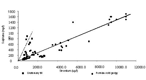 It is important
not to rely simply on sulphate levels as an indication of gypsum dissolution.
Groundwater from the till contains sulphate concentrations of between 660
- 890 mg/l; ordinarily this might indicate gypsum dissolution. However, the
existence of a higher potentiometric surface in the till makes it difficult
to imagine a mechanism that would enable groundwater, containing dissolved
gypsum, to be found 30m above the rockhead surface. Data presented below
show that strontium concentrations correlate generally well with those of
sulphate. This would be expected if the sulphate is from gypsum, as strontium
is concentrated progressively during the evaporation of seawater that leads
to gypsum precipitation. However these data shows that the sulphate and strontium
levels from the till plot on a different trend, thus indicating a different
source. To the north of the area, the Coal Measures outcrop, which was traversed
by the glacier that deposited the till, contains several pyrite-rich horizons
such as the Hutton seam (Younger, 1994). Incorporation of material from this
stratum into the till and its subsequent oxidation would provide the high
sulphate levels independent of gypsum dissolution. This possibility is supported
by the frequent inclusion of coal fragments in the till. The positive correlation
of strontium and sulphate in this case derives from the association of pyrite
with marine bands in the Coal Measures, and therefore reflects the relationship
of strontium with marine conditions.
It is important
not to rely simply on sulphate levels as an indication of gypsum dissolution.
Groundwater from the till contains sulphate concentrations of between 660
- 890 mg/l; ordinarily this might indicate gypsum dissolution. However, the
existence of a higher potentiometric surface in the till makes it difficult
to imagine a mechanism that would enable groundwater, containing dissolved
gypsum, to be found 30m above the rockhead surface. Data presented below
show that strontium concentrations correlate generally well with those of
sulphate. This would be expected if the sulphate is from gypsum, as strontium
is concentrated progressively during the evaporation of seawater that leads
to gypsum precipitation. However these data shows that the sulphate and strontium
levels from the till plot on a different trend, thus indicating a different
source. To the north of the area, the Coal Measures outcrop, which was traversed
by the glacier that deposited the till, contains several pyrite-rich horizons
such as the Hutton seam (Younger, 1994). Incorporation of material from this
stratum into the till and its subsequent oxidation would provide the high
sulphate levels independent of gypsum dissolution. This possibility is supported
by the frequent inclusion of coal fragments in the till. The positive correlation
of strontium and sulphate in this case derives from the association of pyrite
with marine bands in the Coal Measures, and therefore reflects the relationship
of strontium with marine conditions.
Active subsidence
Prior to the 1970s the recorded subsidence around Darlington was limited to a few shallow closed depressions and the Hells Kettles sinkholes. Although a surface depression was mapped less than 1km to the east of Parkside Mr DH Land, the geologist who surveyed the area in 1968-72 did not notice any subsidence in the Parkside area itself (Cooper, 1994). In recent years, however, subsidence has been experienced at Parkside. Similar subsidence has also occurred in the Red Hall Lingfield and Frith Moor areas of the town but the timing of subsidence in these areas is unclear. Although building subsidence rarely exceeds 300mm, the total cost of remedial work to damaged property over recent years has been in excess of £1m.
At this stage several potential causes of subsidence, including clay shrinkage owing to trees and drought induced desicccation are under investigation in addition to gypsum dissolution. The timing of ground subsidence is important because it may be related to other factors such as dry summers, maturation of trees or commissioning of water abstraction wells. Investigation of this issue has begun .