
ROSES STUDY SITES
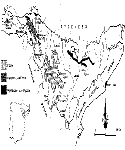
The Ebro Basin lies in a triangular topographic depression, bounded by the Pyrenees to the north, the Iberian Range to the south-west and the Catalan Coastal Range to the south-east. The section of the valley under investigation covers an area of 300 km2 and stretches from Zaragoza City to the villages of Osera de Ebro and Fuentes de Ebro.
The climate is semi-arid (mean annual precipitation of around 350 mm) and a mean annual temperature of15°C . The annual potential evapotranspiration is more than twice the precipitation. The aridity is seasonally accentuated with higher rainfall in spring and autumn. High-magnitude, high-intensity rainfall events also occur, particularly in the summer.
Geological setting
The study area is situated in the central sector of the Tertiary Ebro Basin, the southern foreland basin of the Pyrenees. In this sector, the sedimentary fill of the basin is formed by Miocene continental sediments composed of an evaporitic sequence several hundreds metres thick (Zaragoza Gypsum), overlain by a palustrine-lacustrine limestone formation (Alcubierre Limestone, Quirantes, 1978).
Within the study area, the exposed Miocene sediments comprise secondary laminar and nodular gypsum (more than 200 m in thickness at outcrop) with thin (milimetres to centimetres) intercalations of grey marls. At the left margin of the valley, downstream of Nuez de Ebro, the gypsiferous sequence is underlain by a clay and marl unit with an exposed thickness greater than 30 m. This insoluble and impervious sedimentary unit may play an important role in the hydrogeology, subjacent karstification processes and the consequent subsidence phenomena. Unfortunately, there are no borehole data in this area to provide information about the subsurface lithostratigraphy of the Miocene sediments.
The evaporitic sediments in the study area form a very open syncline, the axis of which is oriented along the Ebro valley, running in a NW-SE direction. Dips along both margins of the valley are lower than 3° (Quirantes, 1978). To the north and south of the valley, the evaporites are capped by the Sierra de Alcubierre and la Plana limestones respectively. These large and flat structural platforms may act as recharge areas for an underground flow (consequent with the structure) discharging through the Miocene sediments in the Ebro valley. Arlegui (1996) differentiated two main sets of vertical joints (with N-S and NW-SE directions) affecting the Tertiary sediments within the Ebro Basin. The NW-SE joints, parallel to the Ebro valley, have a conspicuous influence in the morphogenesis (Benito, 1989; Gutiérrez et al., 1993, 1994). A high density of lineaments parallel to this direction can be recognized (Arlegui and Soriano, 1996).
Geomorphology
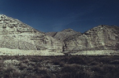
In the stretch enclosed in the study area, the Ebro valley has a marked asymmetric configuration, with a prominent gypsum escarpment at the left margin and a stepped sequence of fluvial terraces at the opposite margin. The asymmetry of the valley is due to the overall entrenchment and northwards lateral migration of the Ebro river throughout its Quaternary evolution.
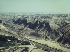 The gypsum
escarpment is approximately 16 km long and follows a NW-SE direction with
a conspicuous rectilinear pattern. The vertical cliffs reach heights in excess
of 120 m and show many different types of slope movement, including slumps
(rotational slides), topples and falls (Gutiérrez et al., 1993, 1994).
The gypsum slumps occur preferentially downstream of Nuez de Ebro, where
the base of the scarp comprises clays and marls, whereas upstream, the fall
and topple of gypsum blocks and monoliths, delimited by the joint systems,
are the most common mass movements. Around Alfajarín, the escarpment
is dissected by gully systems whose entrances are 'hanging'up to 35m above
the base level. These hanging valleys demonstrate the rapid retreat experienced
by the escarpment in relatively recent times thus preventing the gullies
from achieving a smooth longitudinal profile.
The gypsum
escarpment is approximately 16 km long and follows a NW-SE direction with
a conspicuous rectilinear pattern. The vertical cliffs reach heights in excess
of 120 m and show many different types of slope movement, including slumps
(rotational slides), topples and falls (Gutiérrez et al., 1993, 1994).
The gypsum slumps occur preferentially downstream of Nuez de Ebro, where
the base of the scarp comprises clays and marls, whereas upstream, the fall
and topple of gypsum blocks and monoliths, delimited by the joint systems,
are the most common mass movements. Around Alfajarín, the escarpment
is dissected by gully systems whose entrances are 'hanging'up to 35m above
the base level. These hanging valleys demonstrate the rapid retreat experienced
by the escarpment in relatively recent times thus preventing the gullies
from achieving a smooth longitudinal profile.
 Mass movements
seem to be the main process involved in the retreat of the escarpment. The
high solubility of the gypsum would favour the removal by the fluvial system
of the waste material accumulated at the foot of the scarp (Navas, 1988;
James et al.; 1981). Several processes are involved in the development of
slope movements in the escarpment (Gutiérrez et al., 1993, 1994) and
include:
Mass movements
seem to be the main process involved in the retreat of the escarpment. The
high solubility of the gypsum would favour the removal by the fluvial system
of the waste material accumulated at the foot of the scarp (Navas, 1988;
James et al.; 1981). Several processes are involved in the development of
slope movements in the escarpment (Gutiérrez et al., 1993, 1994) and
include:
· Undercutting by the river channel at the base of the escarpment.
· Opening of joints and detachment of slabs and monoliths due to unloading of the overconsolidated Miocene sediments. A stress release in excess of 100 kPa by progressive erosion of the overburden has been estimated.
· Progressive dissolutional widening of the joint-derived cracks .
· Subjacent karstification of the gypsiferous sediments overlying the impervious and insoluble clay and marl unit, leading to subsidence of the gypsum blocks.
· High water pressure (when the water inflow through the joints exceeds the outflow rate during storm events) reducing effective normal stresses and shear strength thus raising the potential for failure along a plane of shear.
· Subsidence at the foot of the scarp due to alluvial karstification, which may enhance the instability of the cliff.
· Wet clays at the base of the scarp may be experiencing creep deformation thus producing lateral spreading of the gypsum blocks.
The fluvial terraces in this sector of the Ebro valley have been studied by Benito (1989) and Soriano (1990), working in the left and right margins respectively. In the left margin, Benito (1989) differentiates two terrace levels above the floodplain: T2: + 10-14 m and T3: +25-35 m (heights above the present channel). Remnants of the terrace T2 occurs at the foot of the gypsum escarpment between Villafranca de Ebro and Osera de Ebro. Up to 10 m of its deposit is locally exposed. The alluvial level T3 is preserved to the NW of La Puebla de Alfindén, towards the confluence between the Gállego and Ebro rivers.
Due to the progressive lateral migration of the fluvial system towards the
north, the most complete sequence of terraces is developed along the right
hand margin of the Ebro. Soriano (1990) recognized 8 terrace levels including
the current floodplain (T8: +198-200m; T7: +156-168 m; T6: +127-132 m; T5:
+106-115 m; T4: +64-73 m; T3: +29-34 m; T2: +10-14 m; T1: +3 m). The most
continuous terrace, T2, is overlapped by alluvial fans fed by the catchments
excavated below La Plana limestone structural platform. The higher terraces
have been reduced to small residues by the dissection of the drainage network.
The deposits of these terraces show anomalous thickenings due to solution-induced
synsedimentary subsidence (Gutiérrez and Gutiérrez, 1998).
Its sedimentological features together with the deformational structures
reveal the presence of paleosinkholes recorded in the terrace sediments.
Conduits beneath the terrace deposits and within the evaporitic bedrock contain
alluvial deposits (emplaced by piping) and are common features.
 Mud diapirs
are also characteristic deformational structures in these terrace deposits
(Figure 3.24). Their origin has been related to the low density of the intruding
marl deposits (Simon and Soriano, 1985,1986; Benito and Casas, 1987 a, b).
Recently, they have been reinterpreted as due to fluid overpressure in low
permeability sediments with a high sedimentation rate driven by dissolutional
synsedimentary subsidence (Benito et al., 1998).
Mud diapirs
are also characteristic deformational structures in these terrace deposits
(Figure 3.24). Their origin has been related to the low density of the intruding
marl deposits (Simon and Soriano, 1985,1986; Benito and Casas, 1987 a, b).
Recently, they have been reinterpreted as due to fluid overpressure in low
permeability sediments with a high sedimentation rate driven by dissolutional
synsedimentary subsidence (Benito et al., 1998).
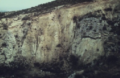
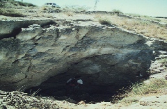
Palaeokarstic conduit in gypsum bedrock filled with alluvial sediments
The gypsiferous terrains along both margins of the valley are dissected by a dense network of flat-bottom infilled valleys, called vales by the local people . These vales are V-shaped valleys filled with dominantly gypsiferous silts, originating from the Miocene gypsum and deposited by alluvial processes. In the main vales, especially the trunk channels, different aggradation or degradation morphogenetic surfaces (equivalent to fill and fill-cut terraces) can be differentiated. These morpho-sedimentary units can be correlated with stepped levels of alluvial fans developed at the mouths of these drainage systems. In the left hand margin of the valley, Arauzo and Gutiérrez (1994) have identified up to four alluvial levels (N4, N3, N2 and N1). N1 and N2 are correlative to the alluvial fans developed on terraces T1 and T2 respectively. The alluvial fan deposits interdigitate and onlap the terrace sediments. Locally both of these deposits show carbonaceous accumulations associated with the generation of dolines by alluvial karstification.
At the mouth of the Val de Nuez a deformed sediment unconformably overlain by unit N1 has provided a radiocarbon date of 9865+/- 85 B.P.. Relative datings using archeological remains found inside the deposits of N2 and N1 have also been obtained. Some of the vales are currently affected by subsidence. The situation is exemplified by the Val de Osera wherein closed depressions, up to 1 km in major axial length, occur. These alluvial dolines are permanently swamped and colonized by a dense palustrine vegetation. In the Val de Torrecilla, at the right margin of the Ebro valley, several sedimentary units are locally thickened and deformed due to synsedimentary subsidence caused by the alluvial karstification of the evaporitic bedrock (Gutiérrez and Arauzo, 1997). This is associated with the development of basin structures more than 100 m long with cumulative wedge-outs at the margins. These paleosubsidence depressions can be considered as a fossil analogue of the currently active subsiding dolines observed in some vales.
Hydrology
The Ebro river is the largest fluvial system in Spain. Its drainage basin covers an area of 85001 km2 with 3.4 km in relief. Most of the water inflow to the Ebro river is supplied by the left margin tributaries, whose headwaters are located in the Pyrenees. The Gállego and Huerva tributaries flow in the Ebro river at Zaragoza city. Up stream of the Gállego and Huerva confluences, the Ebro has a mean discharge of 266.76 m3/s (Ollero, 1996), corresponding to a catchment area of 40434 km2 up stream of the gauging station. The gauging-station of the Gállego river in Zaragoza records 38.82 m3/s in mean discharge (upstream catchment area of 4009 km2). The Huerva river has an average discharge of 2.12 m3/s (upstream catchment area of 1020 km2). In Sástago, around 50 km downstream of Zaragoza the Ebro river reaches 276.83 m3/s in mean discharge (upstream catchment area 48974 km2, thus a reduced specific flow).
The annual flow regime of the Ebro river in the study area depends on the runoff derived primarily from rainfall and secondly from snow melt. The highest mean monthly discharge occurs in February (461.71 m3/s), and the lowest in August (59.37 m3/s) (Ollero, 1996) (Figure 3.30). However, floods are most frequent in the months of January and December. The maximum peak flood discharge recorded at Zaragoza gauging-station during the period 1913-1985 reached 4130 m3/s (2nd, January 1961). In the time interval 1959-1985, the maximum instantaneous discharge has exceeded 3000 m3/s in two flood events.
Hydrogeology
Two interconnected aquifers can be differentiated in the study area. These comprise the unconfined alluvial aquifer linked to the Ebro fluvial system and the possible "aquifer" developed in the evaporitic bedrock which is probably karstic in origin but about which details are scarce. Bielza de Ory and Martínez Gil (1974) considered the behaviour of the evaporites as that of an aquitard, locally supplying or receiving water from the overlying alluvial aquifer. In a study carried out upstream of Zaragoza, these authors indicated that the groundwater heads in the evaporite aquitard are lower than those in the alluvial aquifer. However, progressive increases in the salinity of the alluvial aquifer in some areas suggest the converse.
Sahuquillo (1976) estimated a permeability of 50 m/d and a porosity between 10 and 20% for the alluvial aquifer. The water in this aquifer has high sulphate and calcium concentrations which show an overall increase downstream. However, sulphate concentrations decrease towards the central portion of the valley axis and are also lower along the right margin of the valley. The highest sulphate concentration in the study area have been measured in Nuez de Ebro (1800 ppm) and close to El Eburgo de Ebro (1500 ppm) (Sahuquillo, 1976). The changes in the water table in this aquifer are mainly related to the seasonal regime of the river and irrigation. Locally, depression cones are produced by water pumping, especially in the vicinity of some industrial estates.
Variations in the thickness of alluvial deposits has been interpreted from isopach maps (IGME, 1980) produced from geological cross sections and geophysical logs. Analysis of these data show the irregular geometry of the alluvium-bedrock boundary. This includes sedimentary highs, with less than 5 m in alluvium, and large closed basins containing sedimentary sequences up to 100m thick. These basins are interpreted to originate from synsedimentary solution-induced subsidence (Gutiérrez, 1996; Benito et al., 1998) and show elongated geometries parallel to the valley trend. Four main depocentres can be differentiated preserving 110 m of alluvium in El Burgo de Ebro, 82 m to the NE of Fuentes de Ebro and SE of Osera de Ebro, 78 m between Alfajarín and Nuez de Ebro and 60 m to the W of Pastriz. These indirect geophysical data and their interpretation should be checked with borehole information.
Infrastructure and development
The Ebro river with its fertile plain has been an attractive area for human settlement since ancient times. Zaragoza is one of the largest cities in Spain, with a population of more than 600,000. Until a few decades ago, most of the people living in the villages located along the Ebro corridor made their living from small scale agriculture. However, since the 1960s, economic growth, industrial development and the mechanization of agriculture, have led to the reclamation of more marginal land for cultivation, and the installation of industrial estates.
The area is midway between the most important cities of Spain i.e. Madrid and Barcelona. These cities are connected by a number of communication, transport and pipeline facilities including the Zaragoza-Barcelona highway (A-2) and road (N-II), Zaragoza-Alcañiz road (N-232), a railway linking Zaragoza with the Mediterranean coast, gas pipe lines, and several secondary roads. All these features are potentially vulnerable to dissolution induced subsidence. Subsidence may also cause damage to buildings, including monuments and factories, petrol stations, irrigation channels (like the Canal Imperial de Aragón, built in the XVIII century), crop fields etc.
Active subsidence
In the study area, subsidence is solely observed where Quaternary alluvial deposits overlie Miocene evaporites (mantled karst, sensu Klimchouk, 1996). The surface expression of the different processes involved in the subsidence phenomena are closed depressions or alluvial dolines, which may occur in the floodplain, fluvial terraces, infilled valleys and alluvial fans.
Most of the subsidence features observed in the floodplain are large and shallow closed depressions up to 900 m in major axial length. They are generally elongated in the N130E direction parallel to the valley and the NW-SE joint system. These depressions are sporadically swamped and may host permanently ponded areas surrounded by palustrine vegetation (reeds, rushes, bulrushes). These environments are considered to have a great ecological value. In spite of this, however, a large number of these depressions (recognizable in aerial photographs taken during the 1950's) have been filled in order to reclaim land for agriculture. Many others are used to dump waste material, presumably leading to the pollution of the aquifers.
 Underground
observations by the ROSES partners on 8/11/98 during the second project milestone
meeting revealed that the floodplain sinkholes in the vicinitiy of La Puebla
de Alfindén are true collapse dolines (rather than suffosional or
piping depressions etc.) True phreatic dissolutional textures were observed
in gypsum caves immediately above the water table. Above those features,
void migration by collapse-stoping of roof strata up into the overlying alluvium
was correlated with existing (and forthcoming) surface depressions.
Underground
observations by the ROSES partners on 8/11/98 during the second project milestone
meeting revealed that the floodplain sinkholes in the vicinitiy of La Puebla
de Alfindén are true collapse dolines (rather than suffosional or
piping depressions etc.) True phreatic dissolutional textures were observed
in gypsum caves immediately above the water table. Above those features,
void migration by collapse-stoping of roof strata up into the overlying alluvium
was correlated with existing (and forthcoming) surface depressions.
Subsidence in terraces, alluvial fans and infilled valleys, affecting more cohesive sediments, commonly gives place to collapsed sinkholes. These sinkholes have steep or overhanging walls, up to 4 m deep. The diameter is normally lower than 5 m, although single dolines may reach 150 m in length, and uvalas up to 1 km long have been developed by the coalescence of several enlarging sinkholes. The major axis of these collapse structures tend to follow the direction of the NW-SE joint set.