Summary
This report summarizes the basin response associated to plantation forestry development in Chile. The study took place in experimental catchments (3 to 90 ha) and large river basins (more than 90 km2) located between 37º21’ and 41º17’ south, in central-southern Chile (Figure 1). Water production, peak flows and sediment transport were studied in the experimental catchments analyzing data from rainfall, water level and sediment gauging stations operated directly with the support of the EPIC project. Discharge and precipitation records in the larger river basins were obtained from Dirección General de Aguas and Dirección Meteorológica de Chile. Land use for different time periods were generated during the project using remote images and aero photos.
In small experimental catchments, the reduction of vegetation cover generates increases in runoff and peak discharges, and the biggest effects happen after clearfelling significant proportions of a forest within the catchments. The combined effect of rainfall pattern, catchment size and topography, road density and extent of affected area should also be considered to fully understand and explain the hydrological effects of land use changes in these catchments.
Following clearcutting of the Pinus radiata plantation that covered the 79.4% of the La Reina experimental catchment, runoff and peak flows increase both at annual and summer levels. During the first three years of the post-harvesting period, on average a 110% increase in annual runoff occurred and mean peak flows were 32% higher. After 6 years of development of the new Eucalyptus spp. plantation established in the La Reina catchment in 2000, this forest is increasingly consuming water and annual runoff has initiated a recovery towards pre-harvesting levels. Comparisons of peak flows at the La Reina catchment for pre and post-harvesting conditions indicate that the percentage change for the ‘large’ event category (events with rainfall volumes greater than 50 mm) is less than that resulting from both the ‘medium’ (from 10 to 50 mm) and ‘small’ (from 5 to 10 mm) event size categories. Nevertheless, peak flow medians for 2006 are still higher than those from the pre-harvesting conditions indicating that peak flow values after the removal of the plantation do not show an initial important increase followed of a gradual diminution tending towards the peak discharge levels of the pre-harvesting condition. Although runoff in La Reina has initiated in 2006 a decrease tending towards the levels of the pre-harvesting condition, this is not yet the case of the peak flows. At the La Reina catchment the relationship between extreme rainfall events exceeding 100 mm in total precipitation (the upper section of the ‘Large’ event size category) and extrapolation of this relationship to increasingly larger rainfall event sizes does appear to suggest that, at the scale of extreme events, peak flows with return periods exceeding 10 years do not differ considerably for pre and post-harvesting land cover conditions. This result appears consistent with the suppositions regarding peak flows and extreme events and supports the hypothesis that, as the size of the flood peak increases, the effect of land use becomes less important.
Data from La Reina, Los Ulmos1 and Los Ulmos2 show a decrease in the annual runoff (in percentage of annual precipitation) as the plantations increase their water consumption capacities from about 68% the year after timber harvesting to 36% after 22 years of plantation growth.
In large catchments, annual water reductions associated to afforestation compromising more than 30% of total catchment area have been detected. The highest reduction occurs for Q50% while Q80% and Q90% are much less affected. Since Q80% and Q90% are used to define permanent and continuous Water Rights, it is possible that already existing permanent and continuous water rights could be only marginally being affected by the increase of the planted area. However, those eventual water rights, more associated to Q50%, would be the most possible affected.
At the Caramávida, Duqueco and Mulchén river basins the trends of the relationships between rainfall events from pairs of storms (one storm from the pre-plantation development period and one from the post-plantation development period) and the resultant peak discharge values and extrapolations of the relationships to increasingly larger rainfall event sizes do appear to suggest that at the scale of extreme events, the corresponding peak flow values from pre and post-plantation development land cover conditions do not differ considerably. In these three river basins, the differences in peak flow values from pre and post-plantation development conditions only differ for events with return periods lower than 5 years. These results appear consistent with the suppositions regarding peak flows and extreme events and the findings for the smaller experimental catchments. Although, in the large river basins to the effect of the increase of the afforested area it is necessary to add the corresponding to the variations from one period to the other in the intensity pattern of the precipitations that generate these peak flows and to the differences in areal distribution of precipitation among storms and study periods.
In small experimental catchments, the increases in sediment load after clearfelling can be defined as extreme events not necessarily generated by intense rainfalls but associated to road building and clearcutting during final harvest operations. This reinforces the proposals that the EPIC-UACh group, within the framework of best management practices and definition of standards for harvesting and road planning, has been raising in forums and discussion groups.
Figure 1 Study area
The results presented in this document can be used to provide recommendations regarding forest management options, which allow adequate tree growth rates but are compatible with restrictions on water availability and quality.
Description of project focus basins
The study area
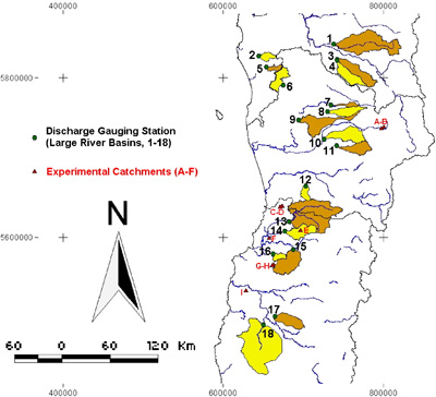
The study takes place in experimental catchments and large river basins located within the Biobío and Los Lagos Regions (latitudinal range between 37º21’ and 41º17’ south), in central-southern Chile, Figure 2. |
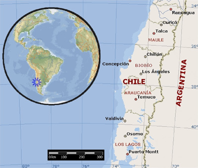 |
Figure 2 Location of experimental catchments (in red) and large river basins (brown and yellow and numbers in black) within the study area
The northern part of the Bíobio Region, from the coast to the Andes Mountains, has a warm temperate climate with a dry season of 4 to 5 months (DMC, 2006). Mean temperatures are below 13°C, with 12°C of annual thermal amplitude and 13°C of daily oscillation, values that are lower in the costal area and that increase toward the east. Mean annual precipitations are over 1000 mm, but in the higher Andes Mountains precipitation is characterized by snow fall and surpasses 3000 mm/year. Cumulative rainfall for the rainy months (May to August) is less than the 70% of the annual total, being the dryer period from December to March with monthly totals lower than 40 mm. |
 |
Most of the Bíobio Region (from the coast to the Andes Mountains) and the intermediate zone of the Araucania Region (up to the 39º south) have a warm temperate climate with a dry season of less than 4 months. In the Bíobio Region annual precipitations vary from 1000 mm to the east of the Costal Mountain Range to more than 3000 mm in the Andes Mountains (most of it is snow), while in the Araucania Region annual totals exceed 2000 mm. Precipitation from May to August equals the 65 to 70% of annual total. Precipitation in summer (December to February) is 5 to 6% of annual totals, which indicates that the precipitation in spring and fall is still important. In the Bíobio Region mean temperatures are lightly lowers than those from the northern part: Diguillín presents 1°C less than Chillán, difference that also occurs in the coast with values which are 1°C or 2°C lowers than in the central valley. The influence of the vicinity of the ocean is noticed in the variations of annual thermal amplitude: 7.5°C in Concepción, 10.3°C in Diguillín and 11.4°C in Coihueco. In the Araucanía Region the thermal regime registers an oscillation of 5°C with a mean annual temperature of almost 12°C, a mean temperature of the coldest month of 8°C and with 15°C in the warmest (DMC, 2006).
The southern coastal area of the Bíobio Region, most of the Araucanía Region and the Los Ríos and Los Lagos Regions have rainy temperate climate with Mediterranean influence. In the Bíobio Region this climate specifically occurs in the province of Arauco, zone influenced by the presence, to the east, of the higher elevations of the Cordillera de Nahuelbuta. Precipitation increases from the Bíobio Region to the south, having Contulmo 140 mm more than in Concepción which is located 170 km more towards the north. In the Araucanía Region precipitations are over 1000 mm/year and occur all year round, with a lower decrease during the summer months. In the Los Rios and Los Lagos Regions annual precipitations are over 2500 mm in the western slopes of the Costal Mountain range (Corral and Niebla), to then decrease to less than 1900 mm in Valdivia (Pichoy weather station) and 1330 mm in Osorno (in the central valley) and increase again to more than 2500 mm towards the Andes Mountains (DMC, 2006). In the Bíobio Region annual thermal amplitude is low (in the order of 8°C from the Contulmo records), reaches important values in the longitudinal valleys and the lower Andes areas of the Araucania Region due to the distance to the coast and its higher continental characteristics, and is moderate in the Los Ríos and Los Lagos Regions by the presence of numerous lakes that help to maintain a thermal homogeneity.
Seven major river basins are comprised in the study area. From north to south they are: Itata (11040 km2), Biobío (24029 km2), Imperial (12054 km2), Toltén (7886 km2), Valdivia (11119 km2 with the 90.8% in Chile and the 9.2% in Argentina) and Bueno (17210 km2). The flow direction of the main rivers is from east to west, from the Cordillera de Los Andes towards the Pacific Ocean (IGM, 1983).
In the inter-fluvium of these main basins, several important rivers develop from the Central valley or the Coastal Range of Mountains to discharge into the Pacific Ocean. These river basins have pluvial regimes and their runoff increases from north to south associated to the increase in precipitation.
Itata and Biobío are the most meridional rivers of the hydrographic region known as “rivers of mix torrential regime in the sub humid zone of Chile” (IGM, 1984). These rivers are characterized by a torrential regime with pluvial peak flows in winter and snowmelt high flows in spring and early summer, and a pronounced low flow period in autumn.
Rivers Imperial, Toltén, Valdivia and Bueno belong to the hydrographic region of the “quiet rivers regulated by lakes of the humid zone of Chile” (IGM, 1984). With the exception of the Imperial River in the other river basins lakes developed during the quaternary glaciation closed by moraines located between the Andes and the central valley. These lakes generate a runoff discontinuity because the rivers upstream the lakes have torrential regimes with pluvial peak flows in winter and snowmelt high flows in spring and early summer, while those flowing downstream are quitter and even navigable.
Description of experimental catchments
Water production, peak flows and sediment transport are been studied in nine experimental catchments, whose locations can be seen in Figure 2 (experimental catchments A to F, in red) and in more detail in Figure 3.
Figure 3 Location of the experimental catchments
The Rio Tres Arroyos and Piedra Santa catchments (5.93 and 2.88 km2) are located on sandy soils in the Andes Mountains in the area of the Malalcahuello Forest Reserve (38°25.5’-38°27’ S and 71°32.5’-71°35’ W). Part of the annual precipitation falls as snow but runoff regime in these two catchments is dominated mainly by rainfall with little snowmelt participation.
The other seven experimental catchments (Aragón1, Aragón2, Pumillahue, Los Pinos, Los Ulmos1, Los Ulmos2 and La Reina) have between 89.8 and 2.9 ha, are all located on the Coastal Range of mountains on red clayed soils under forest plantation activities. All these experimental catchments have pluvial regimes.
Main physiographic, soil and land use characteristics at the experimental catchments are summarized in Tables 1 and 2, while digital elevation models (DEM) of selected experimental catchments are shown in Figure 4. |
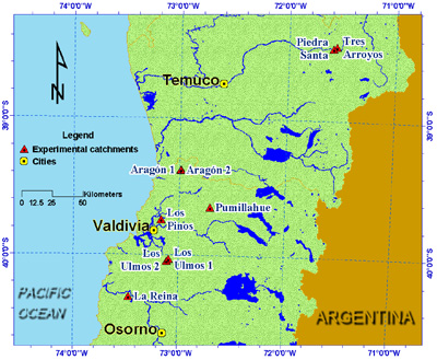 |
Table 1 Main physiographic characteristics of the studied experimental catchments
Catchment |
Area |
Drainage density |
Mean hillslope |
Altitude range |
Road
Density |
Soils |
Numbera |
Name |
ha |
m ha-1 |
% |
m.a.s.l. |
m ha-1 |
|
A |
Tres Arroyos |
593.00 |
15.7 |
39.0 |
1095-1856 |
no |
Sandy soils derived from volcanic ashes. |
B |
Piedra Santa |
287.70 |
28.4 |
31.7 |
990-1705 |
1.5 |
Sandy soils derived from volcanic ashes. |
C |
Aragón 1 |
17.80 |
15.9 |
31.0 |
30-270 |
8.8 |
Red clayed soils generated from volcanic ashes deposited on metamorphic schists. |
D |
Aragon 2 |
8.00 |
4.1 |
36.0 |
30-270 |
19.6 |
As in Aragón1 |
E |
Pumillahue |
2.94 |
22.4 |
21.0 |
99-153 |
0 |
Red clayed soils generated from volcanic ashes deposited on metamorphic mica-schists. |
F |
Los Pinos |
89.80 |
43.8 |
7.6 |
114-224 |
20 |
Derived from volcanic ashes of intermediate to modern age, deposited on metamorphic rocks. Considered as a transition from loamy to red clayed soils. |
G |
Los Ulmos1 |
10.80 |
165.1 |
12.0 |
175-230 |
139 |
Red clayed originating from old volcanic ashes deposited on the coastal metamorphic complex. |
H |
Los Ulmos2 |
16.10 |
58.9 |
20.6 |
155-210 |
87 |
As in Los Ulmos1. |
I |
La Reina |
34.35 |
78.8 |
23.7 |
35-225 |
12 |
Transition from those originating from old volcanic ashes deposited on volcanic conglomerates and those derived from old clays sedimented on volcanic andesitic and basaltic formations. |
* Referred to Figure 2
Table 2 Land use at the experimental catchments
Catchment |
Land uses |
Tres Arroyos |
79% covered by broadleaved native forests, the remaining 21% are sandy volcanic ashes above the vegetation limit. |
Piedra Santa |
56% broadleaved native forest, the remaining 44% is grasslands and shrubs used for cattle rising. |
Aragón1 |
87.3% of catchment area covered with Pinus radiata plantations established in 1989, clearcut between last days of April and July 2005 (winter). Riparian vegetation and roads correspond to 6.2% (1.1 ha) and 0.9% (0.16 ha) respectively. |
Aragon2 |
90.5% of catchment area covered with Pinus radiata plantations established in 1993, 9.5% (0.77 ha) riparian vegetation and roads. No forest operations during the study period. |
Pumillahue |
Second growth forest where Nothofagus oblicua corresponds to 78% of total basal area. Accompanying species are Persea lingue, Laurelia sempevirens with a few Lomatia hirsuta and Aextoxicum punctatum trees. Understory formed by Chusquea quila, Nertera granadensis and Aristotelia chilensis. |
Los Pinos |
33% of catchment area covered with adult Pinus radiata plantations established between 1976 and 1982, 40% are grasslands and 27% riparian vegetation. No forest operations during the study period. Forested area corresponds to 73% of total catchment area. Grasslands are continuously been transformed into natural regenerated second growth native forests |
Los Ulmos1 |
81% of catchment area covered with Eucalyptus nitens plantation established in 1997 with 1,600 trees/ha. The remaining 19% of the area corresponds to roads and riparian vegetation, 19%. |
Los Ulmos2 |
From the total catchment area, 45% is covered with Eucalyptus nitens (7.3 ha) and 23% with Pinus radiata (3.7 ha) forests planted in winter (June-July) 2000. Roads, riparian vegetation and several stands of different species account for the remaining 32% of the catchment area. |
La Reina |
79.4% of catchment area covered with Pinus radiata plantation established in 1977 and clearcut and replaced by a Eucalyptus nitens forest planted in winter (June-July) 2000. Roads and riparian vegetation correspond to 20.6%. |
|
|
|
|
|
Los Pinos |
Los Ulmos 1 |
Los Ulmos 2 |
Figure 4 Digital elevation models (DEM) of selected experimental catchments.
|
Description of large river basins
Water production and peak flows are studied in eighteen large river basins located in areas where plantation forests are distributed (see Figure 2). In this figure, the river basins are numbered from north to south and the names of the rivers associated to this list are presented in Table 3.
Table 3 Large river basins and discharge gauging stations
River basin |
Discharge gauging station |
Numbera |
Name |
Name of location |
Controlled catchment area
km2 |
1 |
Duqueco |
Cerrillos |
1545 |
2 |
Caramávida |
Caramávida |
94 |
3 |
Bureo |
Mulchén |
567 |
4 |
Mulchén |
Mulchén |
434 |
5 |
Butamalal |
Butamalal |
118 |
6 |
Purén |
Tranamán |
354 |
7 |
Traiguén |
Victoria |
106 |
8 |
Quino |
Longitudinal |
344 |
9 |
Quillén |
Galvarino |
734 |
10 |
Muco |
Puente Muco |
650 |
11 |
Quepe |
Vilcún |
386 |
12 |
Puyehue |
Quitratúe |
138 |
13 |
Cruces |
Rucaco |
1740 |
14 |
Iñaque |
Máfil |
424 |
15 |
Collilelfu |
Los Lagos |
581 |
16 |
Santo Domingo |
Rincón de la Piedra |
127 |
17 |
Damas |
Tacamó |
408 |
18 |
Negro |
Chahuilco |
2318 |
| |
|
|
|
* Referred to Figure 2
Land uses for selected river basins (Duqueco, Caramávida, Mulchén, Quillén, Muco and Quepe) for different time periods, are presented in in Table 4, is summary of the land uses considering the categories “native forests”, “plantation forests”, “agriculture” (both grasslands and crop or cultivated lands) and “others” (urban areas or zones without vegetation cover).
Table 4 Land uses evolution in specific large basins
|
Period for land use assessment |
River basin |
Land use types |
1975-1979 |
1987 |
1994 |
1998-2002 |
Caramávida |
NF |
40.31 |
69.21 |
56.14 |
56.14 |
P |
40.49 |
40.49 |
A |
33.44 |
30.44 |
3.38 |
3.38 |
O |
26.25 |
0.35 |
0.00 |
0.00 |
Total |
100.00 |
100.00 |
100.00 |
100.00 |
Duqueco |
B |
36.12 |
35.83 |
32.11 |
32.11 |
P |
32.13 |
32.13 |
A |
48.28 |
52.97 |
32.73 |
32.73 |
O |
15.59 |
11.20 |
3.03 |
3.03 |
Total |
100.00 |
100.00 |
100.00 |
100.00 |
Mulchén |
B |
41.79 |
42.31 |
23.53 |
23.53 |
P |
56.09 |
56.09 |
A |
51.79 |
56.29 |
19.82 |
19.82 |
O |
6.42 |
1.40 |
0.56 |
0.56 |
Total |
100.00 |
100.00 |
100.00 |
100.00 |
Quillén |
B |
- |
3.24 |
6.95 |
7.35 |
P |
8.29 |
10.66 |
A |
84.24 |
84.40 |
81.18 |
O |
12.52 |
0.36 |
0.81 |
Total |
100.00 |
100.00 |
100.00 |
Muco |
B |
- |
8.04 |
38.19 |
38.45 |
P |
6.08 |
8.12 |
A |
86.56 |
55.64 |
53.07 |
O |
5.40 |
0.09 |
0.36 |
Total |
100.00 |
100.00 |
100.00 |
Quepe |
B |
- |
14.45 |
57.17 |
55.87 |
P |
3.91 |
6.33 |
A |
69.55 |
26.72 |
25.40 |
O |
16.00 |
12.20 |
12.39 |
Total |
100.00 |
100.00 |
100.00 |
Data collection
Data collection and monitoring equipment in the experimental catchments
Data collection, monitoring periods and equipments from the operation of the different stations in the experimental catchment are summarized in Table 5.
Table 5 Records and data availability in the experimental catchments
Catchment |
Equipment |
Data-Period |
Period of data missing |
Malalcahuello |
Rain gauge 1 |
1997-2007 |
May2001-Nov2002 |
|
Rain gauge 2 |
2004-2007 |
|
|
Limnigraph |
1997-2007 |
|
|
Weather station |
1999-2007 |
|
|
Rainfall interception plot 1 and 2 |
1998-2002 |
|
Piedra Santa |
Rain gauge |
2004-2006 |
|
|
Limnigraph |
2003-2006 |
|
Aragón 1 |
Rain gauge |
2004-2005 |
|
|
Limnigraph |
2004-2005 |
|
Aragón 2 |
Rain gauge |
2004-2005 |
|
|
Limnigraph |
2004-2005 |
|
Los Pinos |
Rain gauge 1 |
1997-2007 |
May2001-Dec2001 |
|
Rain gauge 2 |
2006-2007 |
|
|
Rain gauge 3 |
2006-2007 |
|
|
Limnigraph 1 |
1997-2007 |
|
|
Limnigraph 2 |
2006-2007 |
|
Pumillahue |
Rain gauge |
2005-2007 |
|
|
Limnigraph 1 |
2005-2007 |
|
|
Limnigraph 2 |
2006-2007 |
|
|
Rainfall interception plot |
2005-2007 |
|
Los Ulmos 1 |
Rain gauge 1 |
2000-2007 |
Mar2002-Aug2002 |
|
Rain gauge 2 |
2006-2007 |
|
|
Limnigraph 1 |
2000-2007 |
|
|
Limnigraph 2 |
2006-2007 |
|
Los Ulmos 2 |
Rain gauge 1 |
2000-2007 |
Mar2002-Aug2002 |
|
Rain gauge 2 |
2006-2007 |
|
|
Limnigraph 1 |
2000-2007 |
|
|
Limnigraph 2 |
2006-2007 |
|
La Reina |
Rain gauge |
2005-2007 |
- |
|
Limnigraph 1 |
1997-2007 |
Nov2003-Jun2005 |
|
Limnigraph 2 |
2006-2007 |
- |
| |
Weather station |
1997-2007 |
No precipitation data from Jan2004-Jul2005 |
|
|
|
|
Discharge data in the large river basins
The information of discharge in the large river basins has been obtained from the data bases of the Dirección General de Aguas (the Chilean Water Authority), according to the detail of Table 6.
Table 6 Available discharge data from large river basins
|
Discharge gauging station |
River |
Name of location
|
Controlled catchment area
(km2) |
Geographic coordinates (UTM) |
Period of discharge records |
Numbera |
Name |
W |
S |
01 |
Duqueco |
Villucura |
1545 |
72º12'' |
37º33'' |
1963-2004 |
02 |
Caramávida |
Caramávida |
94 |
73º29'' |
37º36'' |
1960-1991 |
03 |
Bureo |
Mulchén |
567 |
72º14'' |
37º43'' |
1960-2004 |
04 |
Mulchén |
Mulchén |
434 |
72º14'' |
37º43'' |
1960-2004 |
05 |
Butamalal |
Butamalal |
118 |
73º15'' |
37º49'' |
1960-1996 |
06 |
Purén |
Tranamán |
354 |
73º01'' |
38º02'' |
1960-2004 |
07 |
Traiguén |
Victoria |
106 |
72º19'' |
38º13'' |
1960-2004 |
08 |
Quino |
Longitudinal |
344 |
72º22'' |
38º18'' |
1960-2003 |
09 |
Quillén |
Galvarino |
734 |
72º47'' |
38º24'' |
1960-2004 |
10 |
Muco |
Puente Muco |
650 |
72º25'' |
38º37'' |
1960-2004 |
11 |
Quepe |
Vilcún |
386 |
72º13'' |
38º41'' |
1961-2004 |
12 |
Puyehue |
Quitratúe |
138 |
72º40'' |
39º09'' |
1948-2004 |
13 |
Cruces |
Rucaco |
1740 |
72º54'' |
39º33'' |
1969-2004 |
14 |
Iñaque |
Máfil |
424 |
72º57'' |
39º40'' |
1986-2004 |
15 |
Collilelfu |
Los Lagos |
581 |
72º49'' |
39º51'' |
1987-2004 |
16 |
Santo Domingo |
Rincón de la Piedra |
127 |
73º08'' |
39º23'' |
1992-2004 |
17 |
Damas |
Tacamó |
408 |
73º03'' |
40º37'' |
1986-2004 |
18 |
Negro |
Chahuilco |
2318 |
73º14'' |
40º42'' |
1986-2004 |
* Numbers refer to Figure 2
The fluviometric stations in these river basins correspond to natural sections of the channels partially improved in some cases. The analyzed records are at daily level, because only from mid 1990`s a change from limnimetric records (with reading once to the day) to continuous records with digital data loggers began.
Precipitation data in the study zone
The information of precipitation in the study zone is obtained from records of 230 stations operated by the Dirección General de Aguas and the Dirección Meteorológica de Chile. Sixty six per cent of these stations have daily records while the rest has monthly data, covering different time periods. The location of these stations is in Figure 11.
Figure 5 Location of precipitation stations in the study zone
Results
Land use changes and water production in experimental catchments
The effect of forest removal on runoff was analyzed using a double mass approach comparing data from La Reina and Los Pinos catchments, Figure 6. |
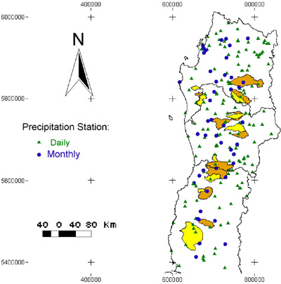 |
Figure 6 Monthly runoff double mass curve analysis between Los Pinos and La Reina catchments for the 1997-2002 study period (from Iroumé et al., 2005)
The significant increase in gradient (from 0.73 to 1.42) of the graph of the first three years of the post-harvesting period (years 2000 to 2002) compared with the pre-harvesting period indicates that more water was discharged from the catchment when the vegetation cover was removed. The increase in runoff commenced at the beginning of February 2000 which coincided with the final period of harvesting operations initiated in October 1999. Projecting the 1997-1999 cumulated runoff trend beyond January 2000, it is possible to estimate “virtual” annual runoff for years 2000, 2001 and 2002 as 802, 1088 and 1175 mm, respectively. Comparing these estimations with the measured annual runoffs for the same years (1773, 1898 and 2427 mm), the double mass analysis indicates a mean increase of 1013 mm/year (971, 810 and 1258 mm in years 2000, 2001 and 2002, respectively). |
 |
Summer runoffs at La Reina catchment were studied for periods under pre-harvesting and post-harvesting conditions. Also, runoffs registered in the Los Pinos, Los Ulmos1 and 2 and La Reina catchments were compared for different summer periods (Iroumé et al. 2005).
Runoffs in the four catchments for one of the summer study periods (December 2000 to March 2001), expressed as daily mean specific discharge (l/s/ha) are presented in Figure 15.
Figure 7 Daily mean specific discharge for period 1st December 2000 to 31st March 2001 in the four catchments (from Iroumé et al. 2005) |
 |
It is possible to appreciate that the Los Pinos catchment has higher baseflows (represented by the flows between storm periods). Its bigger storage capacity derived from larger size and deeper soils compared with that of the other catchments, increases soil water reserves which maintain baseflows in the dryer summer periods. The two Los Ulmos catchments behave similarly, but Los Ulmos1 shows a lower baseflow than Los Ulmos2. The differences seem to reflect the higher water consumption by the established plantation in the first one, while in second the vegetation has been reduced to the riparian areas and some bushes and residues from the previous harvesting operations.
The effect of forest removal in summer water production is analysed using a double mass approach comparing data from La Reina with Los Pinos as the control. Figure 16 shows the relationship between accumulated daily runoff in La Reina and Los Pinos for several summer periods (summer period is assumed from 1st December one year to 31st March following year). |
| Figure 8 Runoff double mass curve analysis between Los Pinos and La Reina catchments for different summer periods (in blue, pre-harvesting conditions; in red, post-harvesting conditions) |
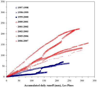 |
A noticeable change in the slope of the accumulated runoff occur since the 2000-2001 plot, indicating an important increase in runoff at the La Reina catchment compared with the two pre-harvesting periods (1997-1998 and 1998-1999). The accumulated daily runoff plot in the first half of the 2000-2001 period follows the same trend than in 1998-1999 (a pre-harvesting period), but an important increase in runoff at La Reina can then be appreciated (the change in the accumulated runoff relationship occurs since the beginning of February 2000, what is consistent with the clearcutting operation initiated in October 1999 but concentrating its major effects at the end of the harvesting period). In the last two months of the 1999-2000 period, the plantation at La Reina was in the final steps of the clearcutting and forest removal operations, and in 2000-2001 La Reina was in a post-harvesting condition. The increase in runoff registered in periods 1999-2000 (especially in the last two months of this summer period) and the following clearly indicates the effect of timber harvesting in this catchment.
Land use changes and water production in large river basins
Impacts of land use change in flow production are presented for the Duqueco, Caramávida, Mulchén, Quillén, Quepe and Muco large river basins (basins number 1, 2, 4, 9, 10 and 11 in Figure 2). Precipitation pattern from the area where these six river basins concentrate has been characterized using rainfall data from the period 1963-2004 registered in the pluviometric stations of Los Ángeles, Collipulli, Cañete, Trupán, Laguna Malleco and Temuco (Maquehue). The location of these six river basins and six pluviometric stations is shown in Figure 9.
Figure 9 Location of selected river basins and pluviometic stations
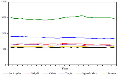
Figure 10 presents the 20-year moving means of these stations, during the period 1963-2004 registered in the pluviometric stations of Los Ángeles, Collipulli, Cañete, Trupán, Laguna Malleco and Temuco (Maquehue). The homogenous behavior of the precipitation records of these stations allows defining as Control station the arithmetic mean of annual precipitation registered in these pluviometric stations. |
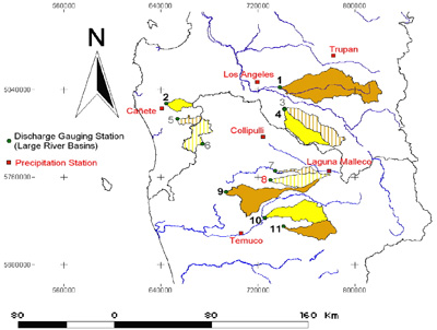 |
Figura 10 Annual precipitation 20-year moving means at the Los Ángeles, Collipulli, Cañete, Trupán, Laguna Malleco and Temuco (Maquehue) weather stations, period 1963-2004.
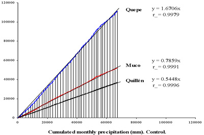
The results of the comparison among cumulative annual runoff of Quepe, Muco and Quillén and cumulative annual precipitation at Control station are presented in Figure 11. |
 |
| Figure 11 Comparison among cumulative annual runoff of Quepe, Muco and Quillén and cumulative annual precipitation at Control station |
 |
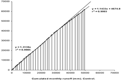
| Figure 12 Comparison among cumulative annual runoff in Caramávida and cumulative annual runoff of Control station |
 |
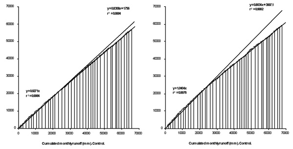 |
Figure 13 Comparison among cumulative annual runoff in Duqueco (above) and Mulchén (below) river basins and cumulative annual runoff at Control station |
Table 7 Reduction in runoff in the Caramávida, Duqueco and Mulchén river basins
|
|
Runoff reduction |
River basin |
Study period |
Year of the break in the accumulative runoff trend |
Period of runoff reduction |
Total runoff reduction in the period in relation with the previous period (mm) |
Annual runoff reduction
(mm/year) |
Caramávida |
1960-1991 |
1979 |
1979-1991 |
3195 |
246 |
Duqueco |
1963-2004 |
1979 |
1979-2004 |
4078 |
157 |
Mulchén |
1961-2004 |
1979 |
1979-2004 |
11442 |
440 |
|
|
|
|
|
|
The decrease in water production since 1979 in these three river basins can be associated to the increase in evapotranspiration capacity of the new forests.
Extreme events and land use changes in experimental catchments
Figure 14 illustrates the relationship between the size of rainfall events and the resultant peak flows at La Reina. This relationship was considered independently for the pre- and post-harvesting periods (1997 to 1999 and 2000 to 2002, respectively), and in these cases the r2 values were 0.77 and 0.46 indicating moderate and lower correlation, respectively. |
Figure 14 Peak flows at La Reina catchment
At the La Reina catchment, mean peak flows for the pre- and post-harvesting periods were 48.3 and 63.8 l/s, respectively. This difference (statistically significant as determined by the t-statistic at a 95% level) represents a mean increase in peak flows of 32% after clearcutting the forest that covered the 79.4% of the area of this experimental catchment.
Figure 15 reveals the relationship between the size of rainfall events and the resultant peak flows at the Los Ulmos catchments, for the period 2000-2002. In each case the r2 values were close to 0.6 indicating moderate correlation. Mean specific peak flows were 2.6 and 2.7 l/s/ha at Los Ulmos1 and Los Ulmos2, respectively, representing a non significant difference (t-statistic, 95% level) of 2.1%. |
 |
Figure 15 Peak flows at the Los Ulmos catchments
|
 |
Notwithstanding the differences in the area of forest cover between the two Los Ulmos catchments, the more developed plantation in Los Ulmos1 seems to have more effect on annual runoffs than in peak flows. Besides the influence of forest cover, the differences in size (Los Ulmos1 is smaller than Los Ulmos2), hillslopes (Los Ulmos2 is steeper than Los Ulmos1), drainage density (165 m/ha in Los Ulmos1 and 59 m/ha in Los Ulmos2) and forest road density (139 m/ha in Los Ulmos1 and 87 m/ha in Los Ulmos2) between the two catchments also affect peak flow processes.
The mean specific peak flow measured at La Reina during the period 2000-2002 (post-harvesting conditions) was 1.9 l/s/ha, lower than those registered in Los Ulmos1 and Los Ulmos2 (2.6 and 2.7 l/s/ha, respectively) for the same period. This disparity may be possibly explained in terms of size as La Reina is larger then the two Los Ulmos catchments.
Extreme events and land use changes in large river basins
The maximum discharges in the Caramávida, Duqueco and Mulchén river basins were analyzed. For these three river basins return periods were assigned (Gumbel frequency analysis) to the daily maximum discharges using the records of all the period of availability of data and those from the periods previous and subsequent to year 1978, in which a break in the water production trend has been detected (see Figures 12 and 13).
The result of this analysis for the Caramávida the river basin is graphically shown in Figure 16. On the other hand, Figure 17 presents the results for the Duqueco and Mulchén river basins. |
| Figure 16 Daily peak discharge return periods for all the period of availability of data and those from the periods previous and subsequent to year 1978, Caramávida river basin |
 |

Figure 17 Daily peak discharge return periods for all the period of availability of data and those from the periods previous and subsequent to year 1978, Duqueco and Mulchén river basins
In the case of the Caramávida and Duqueco river basins, for a same return period the daily maximum discharges from the “after year 1979” period are superiors that the corresponding ones to “before year 1978”. This would be indicating that the development of the plantations in these river basins, that generated a reduction in water production, does not reduce the levels of peak discharges.
In the case of the Mulchén river basin, the daily maximum discharges are smaller in the period of forest development, indicating a potential effect of afforestation in decreasing both water yield and peak flows.
However, the three curves (in Figures 35 and 36) generated by means of the Gumbel analysis for these three river basins do not show statistically significant differences (Kolmogorov-Smirnov test). This could be indicating that the increase of the afforested area would be affecting only marginally the levels of peak flows, when comparing the data from the periods before and after the development of the plantations.
Sediment transport in experimental catchments
Monthly suspended sediment loads (TSS, ton/ha) for catchments Los Ulmos 1 and 2 and Aragón 1 and 2 are shown in Figure 18. |
Figure 18 Monthly suspended sediment load in experimental catchments
In the period January 2004 to October of 2006 it can be appreciated that at the Los Ulmos 1 and 2 catchments, the monthly suspended sediment transport is only significant during July, associated to the periods of major precipitations and runoffs. The value of 3 ton/ha registered in Los Ulmos 2 in July 2005 seems quite high considering that none forest operations took place during the study period in this catchment. |
 |
The plantation of the Aragon 1 catchment was clearcut in winter since April 2005, situation that explain the important increase of suspended sediment load as compared with the sediment load from the neighbouring and undisturbed Aragon 2 catchment. In July 2005, the Aragon 1 catchment monthly suspended sediment load was 6 ton whereas in Aragon 2 monthly suspended load was 6 ton. The investigation in the two Aragon catchments could not continue beyond September 2005, because the amount of sediment transported damaged the instruments and made collapse irreversibly the gauging section. Most of the sediment transport in the Aragon1 catchment originated from cut and fill forest road slopes, in a watershed were the riparian vegetation and buffer protection zones were practically nonexistent.
The increases in sediment load after clearfelling can be defined as extreme events not generated by intense rainfalls but associated to plantation forest operations. This reinforces the proposals that the EPIC-UACh group, within the framework of best management practices and definition of standards for harvesting and road planning, has been raising in forums and discussion groups.
Hydrological simulation scenarios in experimental catchments
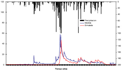
The Los Ulmos2 area model was generated using the existing WaSiM-ETH (Water Balance Simulation Model) physically based, spatially distributed catchment modelling system. Calibration was completed for this catchment for the period January 1 to December 31, 2004. Discharge simulations performed for year 2004 are shown in Figure 19. |
Figure 19 Discharge simulation at Los Ulmos1 experimental catchment using WaSIM
According to the results obtained in this simulation for year 2004, a coefficient of determination (r2) of 0.57 was obtained comparing the measured and simulated values. |
 |
Conclusions
The data presented in this report provides an insight to the basin response associated to plantation forestry development in Chile. Different studies have been carried out in diverse research sites and forest cover conditions and add significantly to the knowledge of the hydrological behavior of forested small and large catchments in the country.
In small experimental catchments, the reduction of vegetation cover generates increases in annual and summer runoff and peak discharges, and the biggest effects happen after clearfelling significant proportions of a forest within the catchments. The combined effect of rainfall pattern, catchment size and topography, road density and extent of affected area should also be considered to fully understand and explain the hydrological effects of land use changes in these catchments.
Following clearcutting of the Pinus radiata plantation that covered the 79.4% of the La Reina experimental catchment, runoff and peak flows increase both at annual and summer levels. During the first three years of the post-harvesting period, on average a 110% increase in annual runoff occurred and mean peak flows were 32% higher. In the wet temperate region with high annual rainfall totals concentrated during winter months as the one where the La Reina catchment is located, timber harvesting has a greater effect in increasing annual runoff than peak flows. After 6 years of development of the new Eucalyptus spp. plantation established in the La Reina catchment in 2000, this forest is increasingly consuming water and annual runoff has initiated a recovery towards pre-harvesting levels.
In the two Los Ulmos experimental catchments, the older plantation in Los Ulmos1 increasingly consumed more water than the three years younger forest cover established at Los Ulmos2 (59 mm in 2000 and 217 mm in 2002), although mean specific peak flows differences between these catchments were not significant. Data from La Reina, Los Ulmos1 and Los Ulmos2 show a decrease in the annual runoff (in percentage of annual precipitation) as the plantations increase their water consumption capacities from about 68% the year after timber harvesting to 36% after 22 years of plantation growth. Reductions of forest cover appear to cause higher runoff and peak flows, although catchment morphology, extent of data sets and rainfall characteristics occurred before and after forest operations should be carefully considered to fully understand the hydrological effects of forest cover changes.
Comparisons of peak flows at the La Reina catchment for pre and post-harvesting conditions indicate that the percentage change for the ‘large’ event category (events with rainfall volumes greater than 50 mm) is less than that resulting from both the ‘medium’ (from 10 to 50 mm) and ‘small’ (from 5 to 10 mm) event size categories as was hypothesized. Nevertheless, peak flow medians for 2006 are still higher than those from the pre-harvesting conditions indicating that peak flow values after the removal of the plantation do not show an initial important increase followed of a gradual diminution tending towards the peak discharge levels of the pre-harvesting condition. Although runoff in La Reina has initiated in 2006 a decrease tending towards the levels of the pre-harvesting condition, this is not yet the case of the peak flows.
At the La Reina catchment peak flow values from pre and post-harvesting land cover conditions only differ for events with less than 10-year return periods. The relationship between extreme rainfall events exceeding 100 mm in total precipitation (the upper section of the ‘Large’ event size category) and extrapolation of this relationship to increasingly larger rainfall event sizes does appear to suggest that at the scale of extreme events peak flow values with return periods exceeding 10 years do not differ considerably for pre and post-harvesting land cover conditions. This result appears consistent with the suppositions regarding peak flows and extreme events.
In large catchments, annual water reductions associated to the increase in forested area have been detected. A reduction of 157 to 440 mm/year in runoff was identified in three large river basins. In two of these basins the reduction in annual runoff can be explained through the increase of annual evapotranspiration capacity of the new planted area, whereas in the third basin annual runoff reductions are controlled not only by increases in forest water consumption. In the three river basins, the values of Q50%, Q80% and Q90% of the summer months are lower since 1979 (the year since reductions in runoff were detected). In the three river basins the highest reduction occurs for Q50%. The values of Q50%, represent periods during the summer with a certain soil water availability, which as of year 1979 is being consumed by the forests covering an important part of the area of these river basins. The values of Q80% and Q90% represent periods during the summer with lower soil water availability in which the physiological activity of the trees is noticeably reduced, and this could be the reason why the effect of the increase of the afforested area on these low flows seems to be smaller. Since Q80% and Q90% are used to define permanent and continuous Water Rights, it is possible that already existing permanent and continuous water rights could be only marginally being affected by the increase of the planted area. However, those eventual water rights, more associated to Q50%, would be the most possible affected.
At the Caramávida and Duqueco river basins, for a same return period the daily maximum discharges from the “after year 1979” period are superiors that the corresponding ones to “before year 1978”, which could indicate that the development of the plantations in these river basins, that generated a reduction in water production, does not reduce the levels of peak discharges. Although, in the Mulchén river basin, the daily maximum discharges are smaller in the period of forest development, indicating in this case a potential effect of afforestation in decreasing both water yield and peak flows. To the effect of the increase of the afforested area it is necessary to add the corresponding to the variations from one period to the other in the intensity pattern of the precipitations that generate these peak flows, and because rainfall is not uniform over a large area even during large storms, differences in areal distribution of precipitation among storms and study periods can add to the variability of peak flows when comparing the periods “before year 1978” with “after year 1979”.
For each of the Caramávida, Duqueco and Mulchén river basins several pair of storms (one storm from the pre-plantation development period and one from the post-plantation development period) were identified and chosen in terms of similar total event precipitation and accumulated rainfall for the previous 7 and/or 14 days. The trends of the relationships between these rainfall events and the resultant peak discharge values for the three river basins and extrapolations of the relationships to increasingly larger rainfall event sizes do appear to suggest that at the scale of extreme events, the corresponding peak flow values from pre and post-plantation development land cover conditions do not differ considerably. In these three river basins, the differences in peak flow values from pre and post-plantation development conditions only differ for events with return periods lower than 5 years. These results appear consistent with the suppositions regarding peak flows and extreme events and the findings for the smaller experimental catchments.
In small experimental catchments, the increases in sediment load after clearfelling can be defined as extreme events not generated by intense rainfalls but associated to plantation forest operations. This reinforces the proposals that the EPIC-UACh group, within the framework of best management practices and definition of standards for harvesting and road planning, has been raising in forums and discussion groups
The results presented in this document can be used to provide recommendations regarding forest management options, which allow adequate tree growth rates but are compatible with restrictions on water availability. |
|


