News & Events
| February / March 2018 - Defra recognises Haltwhistle Burn innovation #NFM #CitizenScience |
A good day spent with #Defra showing off our works on #NaturalFloodManagement at #Haltwhistle Burn to support a national report on the subject @DefraGovUK pic.twitter.com/KOCviL47Ui
— Tyne Rivers Trust (@TyneRiversTrust) 6 March 2018
| Autumn/Winter 2017 - Haltwhistle Burn case study features in national evidence directory |
The Haltwhistle Burn (Slaty Sike) natural flood management scheme is 1 of the Environment's 65 case studies within the Working with Natural Processes Evidence Directory (see case study 44): https://www.gov.uk/government/publications/working-with-natural-processes-to-reduce-flood-risk. The evidence directory was launched at a CIWEM conference in London (October 2017) and Leeds (December 2017).
The citizen science aspect was also presented at the Leeds CIWEM event
"Working with Natural Processes: The Evidence Behind Natural Flood Management"
| 12th April 2017: New publication - Communities can fill the gaps on flooding |
The community-based (citizen science) monitoring scheme and related outputs have been published in the Journal of Hydrology:
- Link to the Newcastle University press release: http://www.ncl.ac.uk/press/news/2017/04/communityfloodmonitoring/
- Link to the Journal of Hydrology paper (it is open access - anyone can download it): http://doi.org/10.1016/j.jhydrol.2017.03.019
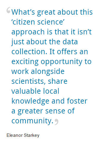
- As the leading researcher, Eleanor Starkey then also gave an interview which was broadcast on BBC Radio Newcastle on 12th April 2017.
Reference: Demonstrating the value of community-based (‘citizen science’) observations for catchment modelling and characterisation by Eleanor Starkey, Geoff Parkin, Stephen Birkinshaw, Andy Large, Paul Quinn, Ceri Gibson. Journal of Hydrology http://dx.doi.org/10.1016/j.jhydrol.2017.03.019
How families living in flood-risk parts of the #NorthEast could play key role in future prevention https://t.co/hbffWVZHn4
— The Chronicle (@ChronicleLive) 24 April 2017
| December 2016 - ITV Tyne Tees flood report |
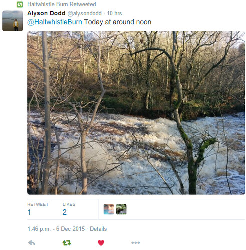
On the 5th December 2015, 'Storm Desmond' hit many parts of the UK, including northern England (and the Haltwhistle Burn catchment). The Haltwhistle Burn citizen scientists collected a large number of observations across the catchment. Scroll through the following album to view some of these:
Storm Desmond has since been reviewed by a number of organisations, including:
- Met Office - observed statistics and impacts
- Centre for Ecology and Hydrology (CEH) - a review of the Winter 2015/16 floods.
One year later, ITV Tyne Tees and ITV Borders decided to broadcast a special flood report to mark the anniversary:
A year on - experts say last winter's floods were UK's most extreme on record: https://t.co/UakuIEYZbC pic.twitter.com/U38QBgcKOL
— ITV News Tyne Tees (@itvtynetees) 5 December 2016
This included coverage of the Slaty Sike runoff management works:
Beautiful frosty morning filming today with @rjsweeneyITV natural #flood management features above #Haltwhistle #northumberland #tynetees pic.twitter.com/UtcccCWbEy
— Eleanor Starkey (@StarkeyEle) 25 November 2016
| April 2016 - European Geosciences Union General Assembly 2016, Vienna (Austria) |
The Haltwhsitle Burn community-based / citizen science project has been presented at the European Geosciences Union (EGU) conference in Vienna, Austria. This event took place on the 17th to 22nd April 2016. It is the largest geoscience conference in Euopre, attracting almost 14,000 scientists.
Two abstracts were submitted and accepted:
1) Demonstrating the viability and value of community-based monitoring schemes in catchment science
View online abstract here: http://meetingorganizer.copernicus.org/EGU2016/EGU2016-9986.pdf
2) Insightful monitoring of natural flood risk management features using a low-cost and participatory approach
View online abstract here: http://meetingorganizer.copernicus.org/EGU2016/EGU2016-6497-1.pdf
To find out more about the EGU 2016 conference, visit http://www.egu2016.eu/
Two posters printed ready for #EGU16 conference next week. Sharing #haltwhsitle burn #nfm #citizenscience project pic.twitter.com/CEo8Y75mAl
— Haltwhistle Burn (@HaltwhistleBurn) 15 April 2016
| 17th March 2016 - ITV News coverage 'Ponds and dams trialled to try reduce flood risk' |
The Slaty Sike natural flood risk management work is featured by ITV. Click on the link below to view the article. There is also a video with some great footage of the features in action back in January 2016:
Ponds and dams trialled to try and reduce flood risk
Our reporter @HannahMcITV investigates if natural defences can help prevent flooding: https://t.co/8ksOQLevbF pic.twitter.com/ruJvP5tYM8
— ITV News Border (@ITVborder) 17 March 2016
| 17th March 2016: Runner-up - The Guardian University Awards 2016 |
The Slaty Sike natural flood management & community involvement work is a runner-up for The Guardian University Awards 2016. A summary can be found on The Guardian page here:
Social and community impact category: award winner and runners up
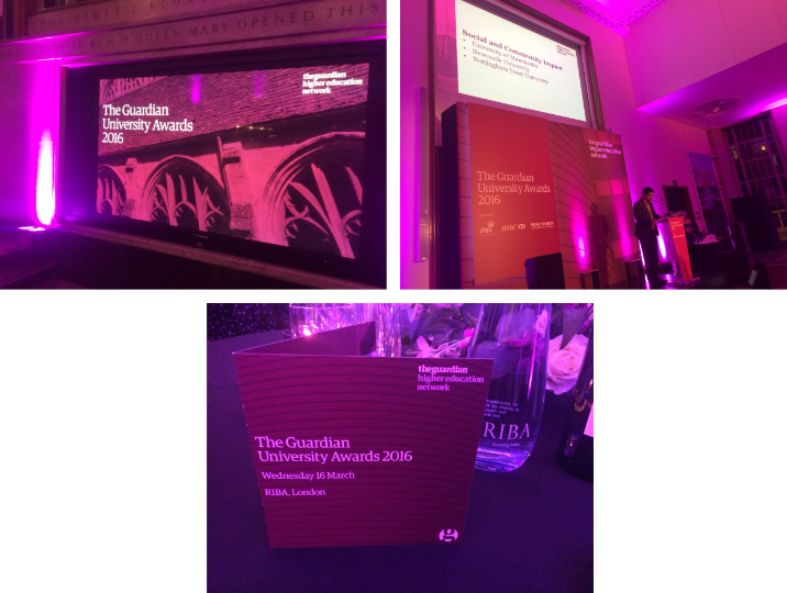
| 1st March 2016 - Haltwhistle Burn project shortlisted for The Guardian University Awards 2016 |
Dr Paul Quinn and Eleanor Starkey's natural flood risk management and community involvement work in the Haltwhistle Burn catchment has been shortlisted for The Guardian University Awards 2016, under the 'Social and Community Impact' category. This follows on from the media coverage which the 'kerplunk' inspired system received back in 2015 (e.g. Chronicle Live and BBC News).
It contributes to one of three categories which Newcastle University has been shortlisted for. Category winners will be announced at the awards ceremony in London on 16 March 2016.
@NCLCeG @TyneRiversTrust natural flood management system up for Guardian University Award https://t.co/drNW5pV9GI https://t.co/G8jrnIDGRs
— Newcastle University (@UniofNewcastle) 1 March 2016
Very cool to have been involved (in a small way!) in this project! Good luck @HaltwhistleBurn @StarkeyEle https://t.co/WsyJDafUyh
— Katy Cook (@KatyCook1986) 1 March 2016
|
12th December 2015: #StormDesmond 4th/5th December |
Even though Cumbria experienced the worst impacts and record-breaking rainfall totals following Storm Desmond, Haltwhistle (and the wider Tyne basin) was also affected in Northumberland.
New rainfall record for a 24-hour period was broken at the weekend with 341.4mm recorded at Honister Pass https://t.co/A4udcXARae
— Met Office (@metoffice) December 7, 2015
24 rainfall totals observed:
|
Gauge location |
Rainfall 4th Dec 09:00 to 5th Dec 09:00 (24 hr total in mm) |
Rainfall 5th Dec 09:00 to 6th Dec 09:00 (24 hr total in mm) |
|
Central Haltwhistle (community-based) |
55 |
60+ |
|
Broomshaw (traditional) |
42.6 |
57.8 |
Prolonged and heavy rain fell over northern England on already saturated catchments. This left both the South Tyne and Haltwhistle Burn to reach record levels. Social media was widely used by the public to share their photos and videos. Members of the Haltwhistle Community also headed out along the burn to collected evidence and impacts before and after the main event. Scroll through the photo album below to view their observations collected, including Slaty Sike natural flood management features which trapped sediment…
“Highest I've ever seen river levels” (member of the Haltwhistle community 05/12/2015 14:58hrs)

Do you have any observations to share for the Haltwhistle Burn catchment? If so please send them in using this form: http://research.ncl.ac.uk/haltwhistleburn/communityhub/submityourobservations/.
|
17th November 2015 – A week of high flows in the Haltwhistle Burn catchment |
Despite having a relatively quiet and dry summer, the Haltwhistle Burn catchment has been saturated for most of November. Following heavy and prolonged rainfall (due to a number of weather fronts passing over northern England), the catchment has experienced particularly high flows over the past week. Several automatic email alarms were received for the Haltwhistle Burn at Broomshaw due to high river levels.
![2015-11-15 1127hrs Haltwhistle Burn Broomshaw [ES]](https://farm1.staticflickr.com/602/23093714646_136c6f93c3.jpg)
How much rainfall was there (in mm)?*
|
Date (Nov 2015) 09:00 – 09:00 next day |
Broomshaw (traditional equipment) |
Central Haltwhistle (community-based approach) |
Haltwhistle Burn outlet (community-based approach) |
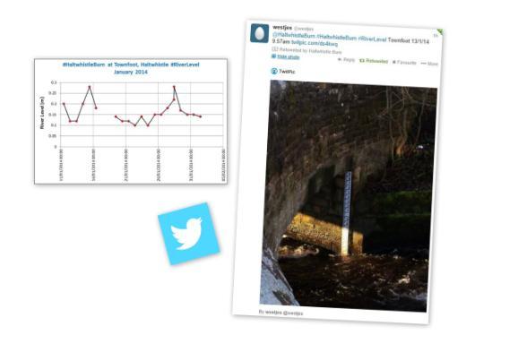
Townfoot, Haltwhistle |
| 6th | 4.8 | 6 | 5 | 3.5 |
| 7th | 8.2 | 10 | 9 | 10 |
| 8th | 18.8 | 22 | 17 | 18 |
| 9th | 5.6 | 7 | 7.5 | 8 |
| 10th | 19 | 21 | 17.5 | 18 |
| 11th | 12.8 | 15 | 16 | 14 |
| 12th | 15.2 | 3 | 18 | 18 |
| 13th | 2 | 3 | 3 | 2.5 |
| 14th | 44.4 |
50 "Mainly overnight. The most I have ever recorded!" |
48.5 | 46 |
| 15th | 2.6 | 5 | 5 | 4 |
*Note that the 24 hour time period starts at 9am on the date listed and ends the following day at 9am (GMT). This provides a 24 hour rainfall total for each data source.
This is the first time that the ‘slow the flow’ natural flood management features have been tested properly in the Slaty Sike sub-catchment. Members of the community and Newcastle University captured their response through photographs and videos. Scroll through the following photo album to see…
This included Newcastle University testing a ‘KiteCam’ – an old camera attached to a cheap kite using elastic bands! The meant that the ponds performance could be captured from above:
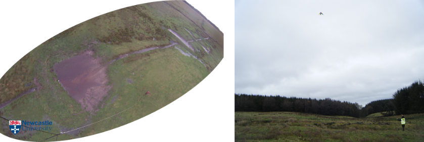
The ponds have certainly slowed the flow by holding back the flood peaks. There is also initial evidence to suggest that the logs have trapped sediment (silt, sand, pebbles and small stones) immediately upstream of the feature and have trapped floating debris:
The logs will need to be inspected as soon as the river levels have returned to normal to see whether sediment has been deposited or scoured elsewere. If anyone from the community would like to come and have a look then please get in touch eleanor.starkey@ncl.ac.uk
| 9th November 2015 - BBC Weather Watchers goes live |
Following a successful trial run, the BBC launched their new 'Weather Watchers' club last week. This facility allows members of the public to contribute to the "great British weather conversation" by submitting weather reports. These reports can be as simple as selecting a weather symbol which best describes the weather experienced (the same weather symbols used by the BBC weather team), adding a photograph or actually submitting real quantitative measurements for rain, wind speed, pressure and humidity.
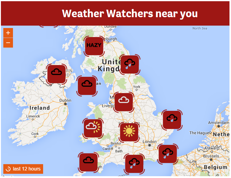
Reports then contribute to the interactive national weather map so you can see the weather experienced by others across the UK.
The BBC describe these weather reports as "nowcasts" which they hope will "help to illustrate the story a little better" (Weather for the Week Ahead (2015) BBC ONE. 5th November, 22:00). Some of these reports have also been shown (and supported) the BBC weather forecasts.
It is great to see the BBC involving the public and making use of crowd-sourced data. This information will also be useful to catchment hydrologists (storm chasers) as reports submitted provide real-time information. It is also a reliable and easy-to-use site for the public.
If you would like to become a weather watcher and use this system to submit your citizen science weather observation then register at http://www.bbc.co.uk/weatherwatchers
|
26th October 2015: Haltwhistle Burn citizen science – now a national case study |
The citizen science monitoring approach implemented within the Haltwhistle Burn catchment is now acting as a national monitoring case study.
Defra’s Catchment Based Approach (CaBA) encourages an integrated and community-led approach to the management of local rivers. Organised by The Rivers Trust, two CaBA citizen science workshops took place during October 2015. A citizen science resource pack was therefore created to support these sessions, with the Haltwhistle Burn citizen science programme acting as a key case study for volunteer-led hydrometric, flood and water quality monitoring. Take a look at:
- The full CaBA citizen science resource pack: http://www.catchmentbasedapproach.org/volunteer-monitoring
- Haltwhistle Burn citizen science case study page: http://www.catchmentbasedapproach.org/best-practice/monitoring/haltwhistle-burn
- Download CaBA citizen science resource booklet (pdf)
“Citizen Science is a fundamental data gathering and engagement tool for Catchment Based Approach (CaBA) partnerships to help develop understanding of the issues in catchments and also to engage their local communities in identifying and delivering solutions” (CaBA, 2015).
Find out more about CaBA here: http://www.catchmentbasedapproach.org/
| 28th - 31st August 2015 - Haltwhistle Burn project in the media! |
Our new natural flood management (NFM) feature located along the Slaty Sike (and is inspired by the children’s game 'Kerplunk') is in the media this week...
Newcastle University Press Office: http://www.ncl.ac.uk/socialrenewal/news/item/kerplunksystemslowstheflow.html
Chronicle Live: http://www.chroniclelive.co.uk/news/north-east-news/haltwhistle-flood-protection-scheme-inspired-9942573
BBC Science & Environment: http://www.bbc.co.uk/news/science-environment-34087255
BBC News documentary 'Weather World': catch up on BBC iplayer http://www.bbc.co.uk/iplayer/episode/b0698z2l/weather-world-28082015
BBC Look North & BBC Breakfast: the BBC also showed a clip of the feature a few times on Look North and the BBC Breakfast channel. Both Newcastle University and Tyne Rivers Trust were interviewed.
It is expected that this 60m long feature will help to trap stones and debris during and after heavy rainfall events - material which would normally collect downstream under bridges and culverts, causing bloakcages, water quality issues and further flood risk in the town of Haltwhistle. The game Kerplunk also helps people to understand how the naturally engineered feature works in order to improve water quality and reduce the impacts from runoff.
Thank you to all members of the River Watch Group and wider community for sharing their rainfall, river level, water quality and flood observations. These have helped to highlight hotspot issue areas and work out where this new feature should be located.
How the game Kerplunk has inspired a new flood management scheme @HaltwhistleBurn @TyneRiversTrust http://t.co/QnE6MHjbEI
— Newcastle University (@UniofNewcastle) August 28, 2015
#Haltwhistle #Northumberland flood protection scheme inspired by children's game Kerplunk http://t.co/JKMKlIj4ke
— Haltwhistle Burn (@HaltwhistleBurn) August 28, 2015
|
July 2015: Working with Natural Processes (Natural Flood Management) in the Haltwhistle Burn Catchment |
Throughout Tyne Rivers Trust’s Catchment Restoration Funds (CRF) project, working with natural processes (WwNP) and slowing the flow to help improve the quality of the water environment has always been high on agenda. WwNP, for example natural flood management (NFM), involves constructing intervention features and introducing land management measures which work with natural processes (rather than against) in order to reduce flood risk, sediment, water quality and subsequently, habitat degradation issues. This approach is becoming popular in more rural locations in order to avoid the construction of engineered features which are regarded as being large, obtrusive, expensive and unsustainable.
Through a participatory action and citizen science approach, the Haltwhistle Burn PhD project has also encouraged community-based monitoring activities and observation sharing. This co-production of knowledge has helped to confirm:
- Where all the main flood risk issues are in the catchment;
- Which key tributaries contribute to the flood peak in the town;
- Where rapid erosion of sediment occurs (therefore the sources of sediment);
- Which tributaries suffer from poor water quality;
- Where sediment and debris is deposited, causing blockages along the burn.
![]()
With support from Tyne Rivers Trust, the Haltwhistle Burn River Watch group has helped to install a number of NFM features and supporting land management practices over the past two years. Features have been chosen to ensure the watercourses are not disturbed under normal and low flow conditions. Instead they have been designed so that they help to slow, store and filter peak flow during storm conditions. Why? This approach holds flood water back at source in the upper parts of the Haltwhistle Burn catchment and releases it more slowly once the storm has passed. As a result, the flood peaks are much lower once they reach the town i.e. the impact zone. ‘Leaky dams’ have been a popular choice here - these are tree trunks which are placed perpendicular to the flow of the water. This causes peak flows to deflect and spill out onto the surrounding floodplain. With the help of extra ‘obstacles’ (such as brash bundles), the floodplain is also rougher which helps to slow down the velocity of the water and allow sediment to settle out (rather than clogging up culverts and bridges downstream). So in short, by slowing the flow, less damage and erosion is caused, more sediment can settle out, less habitats are washed away and flood waters are released over a longer period of time.
Two interesting examples of NFM and the community include:
- Leaky dams along the Pont Gallon Burn above High Edges Green. To see how they reacted during the December 2014 floods, watch this video (which shows high velocities entering the NFM zone which then right down once they filter through the dams and brash bundles): https://flic.kr/p/qBs2vn. Photos and videos are the most popular type of observation collected by citizen scientists. Is this video therefore meaningful and useful to catchment stakeholders?
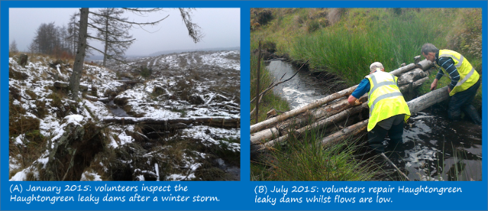
- Leaky dams at Haughtongreen (a tributary of Greenlee Lough): Following the December 2014 floods, volunteers from the River Watch group travelled up to the top of the catchment, beyond Greenlee Lough in January 2015 to inspect a set of leaky dams (which they helped to build in 2014). They found that some of the features needed repairing and therefore took photographic evidence. This triggered the group to head up a few weeks ago to repair any damage. Community-based monitoring has therefore supported the maintenance of NFM features.
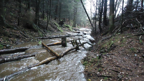
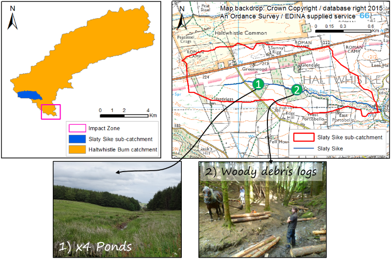
New NFM features installed - the Slaty Sike:
A runoff management plan was developed for the Slaty Sike (a 1.1km2 headwater sub-catchment of the Haltwhistle Burn) in the form of a report and interactive map. After a few months of planning and discussions with land owners, permission was granted to construct a set of ponds and woody debris features. They were officially constructed w/c 30th June 2015, with horse power to help shift the logs into place! The two sets of features have been designed to offer multiple benefits, particularly those related to water quality and flood risk.
Where are the Slaty Sike features located?
It is anticipated that the River Watch group will carry out regular monitoring activities in order to i) see how they perform over time and under different flow conditions and ii) keep an eye on any maintenance required.
Further links:
- Take a look at the following Flickr album to view all catchment management measures implemented within the Haltwhistle Burn catchment: https://flic.kr/s/aHsjW9Ug2v.
- Read more about the Haltwhistle Burn runoff management plan: http://research.ncl.ac.uk/haltwhistleburn/communityhub/catchmentmanagement/
- Tyne River Trust CRF Technical report: http://bit.ly/1LxLRlD.
Please share this news item:
Facebook | Twitter | Google+ | Send Email
| 9th June 2015: Update from NCC Hemmel Burn flood risk study & call for photos |
The Hemmel Burn is a culverted watercourse which passes underneath the middle of Haltwhistle, including Haltwhistle Community Campus. It runs through a pipe south-east towards the Haltwhistle Burn near the B6322 road.
Various organisations, including Northumberland County Council, are working together to understand and help reduce the risk of flooding from the Hemmel Burn. They are currently asking the community to share any photos or videos of flooding from the burn in order to improve their flood models. They are also interested in any known flood depths, dates, times and locations.
Read the latest newsletter (June 2015) to find out more about the project, progress to date and to find relevant contact details to send flood information to.
June 2015 - Hemmel Burn flood risk study (ii) PDF 157Kb
Hemmel Burn Newsletter 1 (June 2015)
|
19th & 20th May 2015: Haltwhistle Burn project features as a key case study in national citizen science conference workshop |
The River Restoration Centre (RRC) encourages sustainable river restoration and enhance schemes across the UK. The team is regarded as being the ‘UK’s expert information and advice centre’. They held their two day 16th annual conference in Northamptonshire on the 19th and 20th May 2015. As we move further towards a total ‘catchment based approach’, which encourages a community-led approach to the management of our water environments on a local level, the conference was themed around people and process based river management.
There were various talks across the two days, each presenting river restoration case studies from around the UK. It was clear that most speakers were stressing the importance of monitoring as it provides stakeholders with evidence, thus confidence. Many restoration projects admitted that monitoring is often ‘forgotten about’ beyond the lifetime of the project. Local River Trusts were also reminding the audience that i) they need low cost monitoring solutions and ii) it’s not just about the quantity and quality of the data; involving the community in the catchment management process is equally as important.
Citizen science is a fairly new phenomenon in the catchment management sector, mainly because professionals have developed and refined technique over many years in order to monitor weather and water parameters. This was one of the first times that citizen science was a key component of this national conference in the UK.
The Haltwhistle Burn citizen science project was one of five case studies presented during the citizen science workshop. Haltwhistle was used to emphasise how local data is still inadequate in rural UK catchments and community-based monitoring techniques can be used to fill the gap. Engagement, tools and monitoring techniques were described to show how evolving technology and communications provides a timely and low-cost solution to data collection, whilst offering various social benefits, including community empowerment. The abstract and presentation slides can be viewed on the RRC website.
Other key quotes / findings from the conference included:
- When analysing the effects of natural flood management, trends are enough to convince and provide credibility rather than statistical significant results
- Evidence is required to secure future funding and influence policy
- “Following our restoration project we realise the importance of understanding the catchment and the need for monitoring”
- Data must be fit for purpose
- “We must understand how each sub-catchment contributes to the flow and flood peak”
- Catchment management now includes both human and physical geography – we must appreciate social, economic and political factors.
- "Citizen science - is it time to join up?"
Was v.pleased to see #citizenscience key component of this years #RRC2015 conference. Great workshop y'Day morning pic.twitter.com/9VQctkaq30
— Haltwhistle Burn (@HaltwhistleBurn) May 21, 2015
| April / May 2015 - Modelling the Haltwhistle Burn catchment with community's data |
#HaltwhistleBurn community have observed their #water #environment. Now using their data to improve #flood models ☔
March/April 2015: An update & new tools disseminated to river watchers
After well over one year of community-based monitoring activities in the Haltwhistle Burn catchment, we have had massive amounts of data submitted and local knowledge shared.
The most popular types of data collected include...
- 24 hour rainfall totals
- Daily river levels
- Photos and videos taken before, during and after flood events
What has worked well?
- Use of Twitter to communicate with the wider community, share observations and receive a ‘heads-up’ immediately before or during a heavy rainfall event.
- Use of the Haltwhistle Burn (this) website
- Overall curiosity and involvement, as well is attendance during river watch meetings
- Involvement of the (already formed) river watch group and wider community
- Range of age groups who have taken part in either a one-off monitoring activity (event) or have been involved in on-going monitoring activities.
- Some volunteers have travelled to other parts of the catchment to observe and characterise
- Best practice has been picked up by other communities in Northumberland, including Acomb (http://www.action4acomb.co.uk/action4acomb/environment/citizen-science/) and more recently, Wark.
What hasn't worked so well?
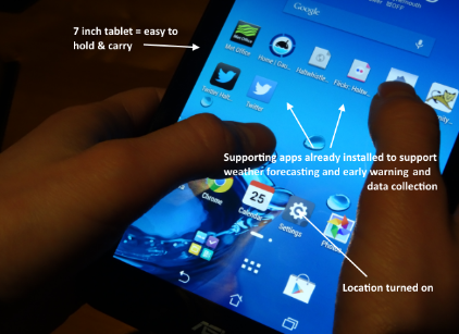
As part of the project a number of tools and resources have been developed, including the river watch photo posts and the community river and weather Android app. They are being used primarily to a) support engagement with all age groups b) provide new and exciting opportunities c) make use of communication technologies d) support data collection, submission and sharing activities (with the potential for this to be in real-time) and e) help create more consistent data records and reduce errors during the data collection phase.
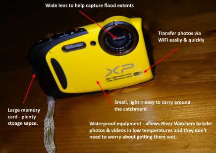
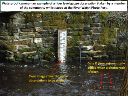
In order to encourage use of new technologies during the data collection phase, 2 waterproof cameras and 2 small Android tablets have been distributed amongst the river watch group in Haltwhistle. Although they are initially being used by volunteers who would normally collect the bulk of observations along the burn (particularly before, during and after a flood event), it is anticipated that these tools will be shared with the wider river watch group. These new tools will help collect high quality observations along the burn and will contain location, date and time information.
16th March 2015: Environment Agency investigates & appraises involvement of volunteers in achieving flood risk management
A research study has been undertaken on behalf of the Environment Agency to find out how valuable working with volunteers is in order to achieve their flood and coastal risk management (FCRM) outcomes. The study concludes that volunteers add value by:
- Building community resilience;
- Enhancing flood risk preparedness;
- Making communities more self-reliant;
- Supporting the Environment Agency and other relevant organisations
Surveys indicate that food volunteers are predominantly male, over the age of 54, retired and from rural communities. Activities carried out by volunteers also involve monitoring river levels, being part of a flood group or forum, raising awareness and ensuring the wider community are prepared and operating flood gates or pumps.
Volunteering is described as helping to provide a “dynamic multi-way flow of information”
Overall the research concludes that volunteers are extremely important in the flood risk management and resilience process. Further research is required to fully understand the value of the contribution made by volunteers.
Investigating & appraising the involvement of #volunteers in achieving #flood risk management outcomes http://t.co/vw8tilNsS4 | @DefraNature
— Haltwhistle Burn (@HaltwhistleBurn) March 16, 2015
9th March 2014 – New guidance document for community-based catchment management
A new booklet on ‘Community Involvement in UK Catchment Management’ has been published by the Foundation for Water Research (FWR) this week. The FWR is an independent charity with a mission to educate the public on water and wider environmental issues, and a vision to support a well informed and knowledgeable society.
The booklet, co-authored by Eleanor Starkey and Geoff Parkin (Newcastle University) has been written to help communities to understand how they fit into the ‘modern day’ catchment management process as sources of valuable local knowledge, so that they can begin to monitor and manage catchments on a local level. The booklet also defines what a ‘catchment’ actually is and the typical problems we are face with (e.g. flooding and poor water quality). A number of citizen science and community-based case studies are also presented to emphasise how the rapid growth in technology and communication facilities can be used in innovative ways to increase levels of knowledge, complement current policies, and support the management of the water environment.
Case studies from Northumberland are also included, for example, the role of Tyne Rivers Trust, the Belford natural flood management scheme and Acomb’s Red Burn flood plan. The Haltwhistle Burn project is also presented as the main case study within the booklet.
The booklet can be downloaded for free using the following link: http://www.fwr.org/Catchment/frr0021.pdf.
New guidance on community-based catchment management by @StarkeyEle http://t.co/7W2NSTj2cM #impactncl @NCLCeG pic.twitter.com/CnY9P4Vcef
— Haltwhistle Burn (@HaltwhistleBurn) March 7, 2015
6th March 2015 – SINATRA research team visit Haltwhistle Burn catchment
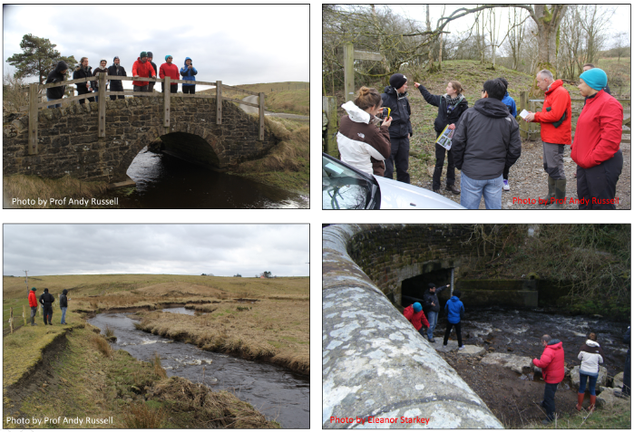
SINATRA researchers (the ‘geomorphologists’ and ‘modellers’) from Newcastle University visited the Haltwhistle Burn catchment today. They visited the catchment to visually characterise the upper, middle and lower reaches, including the Townfoot ‘impact’ zone. The team were also interested to see maximum flood levels/extents and find out what monitoring equipment is installed within the catchment (rain gauges and water level recorders) as they need this type of information in order to build and run their computer models. Such models can be used to, for example, reconstruct past flood events and understand where sediment will erode or deposit.
‘SINATRA’ stands for Susceptibility of catchments to INTense RAinfall and flooding, a project which is about flooding from intense rainfall and understanding of how different types of catchments and areas respond to intense rainfall. The overall aim of SINATRA is to improve the national capability for forecasting flooding from intense rainfall. There are a handful of focus catchments, including the Haltwhistle Burn which represents a small, rapid response catchment.
For more information, visit the SINATRA website: http://www.met.reading.ac.uk/flooding/
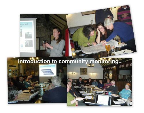
17th February 2014 - Haltwhistle Burn River Watch meeting
Last night the Haltwhistle Burn River Watch meeting was held at the Comrades Club in Haltwhistle. Key items on the agenda included:
- Haughtongreen Burn tree planting and leaky dams;
- River Watch tool storage & maintenance;
- Fallen trees in the Burn (flood risk issue);
- Himalayan Balsam Bashing;
- Townfoot culvert: sedimentation;
- Tree & willow management;
- Your catchment observations over 2014;
- Evidence collected during the December 2014 floods;
- Citizen science: what are your observations are being used for?
Miss #HaltwhistleBurn River Watch meeting last night? A summary is available here http://t.co/2yt8aHzWjo #Haltwhistle pic.twitter.com/yipeyYxosF
— Haltwhistle Burn (@HaltwhistleBurn) February 17, 2015
If you missed the meeting and/or want to take a look at some of the material, tools and interactive resources discussed during the session, then you can find them by clicking on the following links:
- A copy of the slide show used during the meeting;
- Haltwhistle Burn Flickr (photo & video) albums, including key flood events;
- The Haltwhistle Burn Community Hub: a resource for the river watchers;
- An underwater video of the White Clawed Crayfish in the Caw Burn;
- Pont Gallon Burn: upstream of the leaky dams & the dams in action (22nd December 2014);
- All catchment data collected during 2014: Interactive maps & graphs.
- Draft Slaty Sike runoff management plan: report and interactive map.
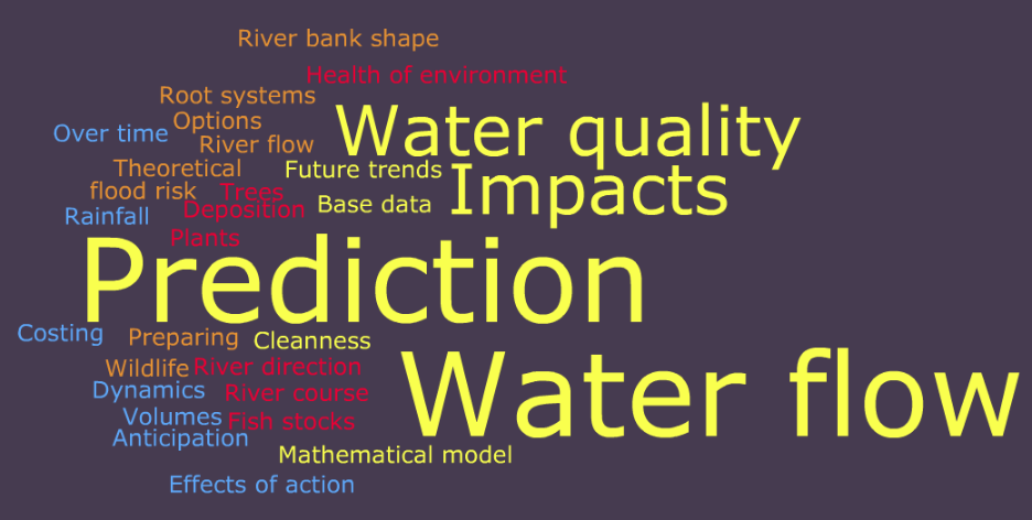
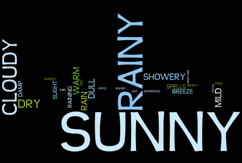
What does the term “modelling” mean to you in the context of catchments (rivers)?
During the meeting, River Watchers also took part in a mini research study. They were asked to note down three key words or phrases which they would use to describe modelling in the context of catchments and rivers. Their answers are shown below in a word cloud, with 'prediction' and 'water flow' being the most common key word/phrase. This study will be repeated again during a future river watch meeting to see whether a ‘citizen science’ and ‘community-based’ approach supports the catchment management process.
Haltwhistle Burn River Watch Meeting (16th Feb 2015)
PDF 4,434Kb
Download a copy of the slide show used during the meeting (PDF).
8th February 2015 - Help monitor the Burn's river levels over time
Live near/walk past #HaltwhistleBurn gauge boards? Help observe burn over time by taking pic or video #Northumberland pic.twitter.com/kROStd1Sul
— Haltwhistle Burn (@HaltwhistleBurn) February 8, 2015
26th January 2015 – Haltwhistle Burn Citizen Science project to be presented during RRC 2015 annual conference
The Haltwhistle Burn Citizen Science project will be presented by Eleanor during the River Restoration Centre’s (RRC) annual conference in May 2015. A 3 hour workshop around citizen science is also being planned by the RRC team. Take a look at the conference programme to find out more.
14th January 2015 - Rivers/canals/lakes are in top 5 places people spend time outdoors, a report confirms
Natural England has published a report today 'Monitor of engagement with the Natural Environment' (annual report from a 2013-14 survey). Findings suggest that:
- 58% of English adult population claimed to have visited the outdoors at least once a week (24 million adults);
- 44% of the English adult population strongly agree that spending time outdoors (in their garden) is an important part of their lives;
- 35% of the English adult population are concerned about damage to their natural environment.
However, the report doesn't make any reference to citizen science. Important questions are therefore stimulated following the release of this report... Does citizen science increase the number of people out and about within the natural environment? Can citizen science trigger behavioural change, therefore increase the number of people concerned about the natural environment?
New report from @NaturalEngland says rivers/canals/lakes are in top 5 places people spend time outdoors #MENEreport http://t.co/ldi9hsehMk
— CatchmentConnections (@LifeNearTheWear) January 14, 2015
1st January 2015 – Collecting evidence during & after recent high flows + floods (22nd to 24th December 2014)
Thank you to all river watchers who have shared their local knowledge and data collected during the recent high flows and floods in the #HaltwhistleBurn catchment. All evidence collected so far has been uploaded to Flickr and an album has been created – take a look below. The album has been arranged by date & time so you can see how the event unfolded.
Do you have any photos, videos, anecdotes or other observations to share? If so, please send them in using our online web form which can be found here: http://research.ncl.ac.uk/haltwhistleburn/communityhub/submityourobservations/.
This community-based approach is helping researchers, catchment managers and the community themselves understand how the Haltwhistle Burn catchment responds.
#Flood observations shared by #HaltwhistleBurn community. Here is #CawBurn @ #GibbsHill Dec14 compared to April+Sept pic.twitter.com/inZbQhyFqJ
— Haltwhistle Burn (@HaltwhistleBurn) January 6, 2015
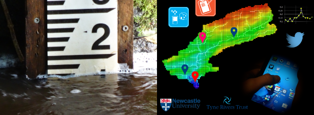
Two river watch photo post signs have been erected along the Haltwhistle Burn in Haltwhistle, to encourage the wider community to take part in the project.
It is anticipated that the small signs will attract passers-by to take a photograph or visually observe the river level gauge board (giant ruler). River levels also need to be accompanied by a date and time. The aim is to get as many people as possible to take part in order to collect data about how the Haltwhistle Burn responds over time – during low, normal and high flows. All observations are important as they help to paint the wider picture.
Locations: look out for the small A5 signs along the Haltwhistle Burn, on the footpath at 1) the bottom of Castle Hill in Townfoot 2) Opposite the footbridge at Broomshaw Hill.
Sharing your observations: read the signs, they provide the instructions. Remember, you don’t have to have Twitter in order to take part. You can email or send them online using this form: http://research.ncl.ac.uk/haltwhistleburn/communityhub/submityourobservations/
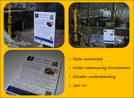
See if you can spot the two signs next time you walk along the burn!
10th December 2014 - Credibitlity of #CitizenScience data
2 volunteers each measuring daily #rainfall in #Haltwhistle. Nov 2014 totals one observes 82mm & other 82.5mm #CitizenScience #credibility
— Haltwhistle Burn (@HaltwhistleBurn) December 10, 2014
1st December 2014: Monthly rainfall totals in Haltwhistle
Members of the Haltwhistle Burn community are observing rainfall in their back yards and gardens on a daily basis. The January 2014 - November 2014 monthly rainfall totals are presented below (have a go with the interactive plot). A total of 82mm of rain fell over Haltwhistle in November. So far a total of 988.5mm of rain has fallen during 2014, with August being the wettest month and September being the driest.
25th October 2014 – Citizen Science: Engagement & Innovation
Catchments (drainage basins) are complex naturally and are also altered by human activities. Data (evidence) is required on a local level in order to fully appreciate how individual catchments respond on a range of different scales and time frames. Evidence is also required in order to provide stakeholders with confidence when managing catchment issues (such as flooding) and implementing mitigation measures. ‘Citizen Science’ allows members of the public to be part of the data collection phase. Although citizen science is not a new idea, growth in technology and communications are allowing people to take part much more easily and widely than ever before.
One of the problems we have found with citizen science in the context of hydrology and catchment management is that when targeting rural catchments, like the Haltwhistle Burn, communities are small but the river network is large. Successful engagement is therefore essential if we want to encourage people to become citizen scientists, collect catchment-wide evidence and increase their understanding of catchment behaviour.
How can we engage with new people? How can we get local people exploring the full extent of their catchment? How can we understand hydrological processes if we don’t have data available for the whole catchment? The answer is innovation…
The Haltwhistle Burn catchment is usually full of people walking – whether this is along the Pennine Way, across Hadrian’s Wall, along the Burn’s footpath or around the Greenlee Lough nature reserve. We therefore teamed up with the Haltwhistle Walking Festival and ran a speciality walk on the 18th October 2014 entitled “Citizen Science – Water Management around Greenlee Lough”. Greenlee Lough area drains the upper catchment so it was a great way of getting people to explore and monitor this location.
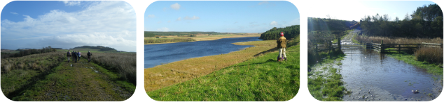
The ~7 mile walk started at Gibbs Hill car park, passed over private land and joined the nature trial footpath. There were a number of stopping points around the route, including one of Tyne Rivers Trust's catchment management demonstration sites and three water quality monitoring sites. Unlike river levels and flood extents, water quality (thus pollution related issues) are often difficult to spot visually so we need to rely on observing parameters which provide an indication of water quality. Simple, low-cost monitoring techniques were adopted which provided quantitative and semi-quantitative values for dissolved oxygen, temperature, nitrates/nitrites, phosphates, pH, algae and water clarity. The water quality monitoring sites were chosen based upon the locations of where the Environment Agency is currently monitoring various water quality parameters. This meant that we had a direct comparison between ‘professional’ and ‘citizen science’ data. The Environment Agency’s data has been requested and will be analysed alongside the citizen scientist’s data once it has been delivered.
Besides looking at the quality of the data collected, there were many other reasons why citizen science for water management was included within the walk:
- Test out monitoring kits, training cards and procedures = tweak and co-produce;
- Allow ‘punters’ to appreciate catchment connectivity;
- Encourage existing river watchers to explore other areas of the catchment (in the case of the Haltwhistle Burn catchment, areas north of the Military Road and Hadrian’s Wall);
- Engage with new/different groups of people;
- Increase the spatial and temporal coverage;
- Tap into an existing initiative (event) which was led by locals – share interests;
- Allow people to try new monitoring techniques and appreciate other catchment issues (other than flooding).
“Thank you for your interest and enthusiasm, showing us the catchment project" "Can I take some of the pH strips home with me? It will be interesting to see how it alters during the winter runoff” Participant on the Haltwhistle Walking Festival (Citizen Science speciality walk), October 2014
2nd October 2014: Community-based rainfall monitoring - why?
July and September have been dry months this year. In fact, the Met Office has just confirmed that September 2014 has been the driest September since records began in 1910. This is significantly different to many of the summer months in recent years e.g. June 2007, September 2008 and July 2012.
Members of the Haltwhistle community are monitoring 24 hour rainfall totals themselves in their back gardens with simple manual plastic rain gauges. Although there are various (and perhaps obvious) disadvantages associated with this approach as oppose to automatic and 'accurate' rain gauges which the hydrological community typically use, it is a simple, low-cost alternative way of collecting rainfall data. Why is this important? National rainfall monitoring networks are sparse and expensive to run. It is unusual to find even one rain gauge monitoring within (or even close to) small rural catchments. If we want to really understand how individual catchments respond following heavy rainfall or prolonged periods of dry weather, we need LOCAL DATA! This data can feed into computer models and help plan, design and implement catchment-related mitigation measures, for example, Natural Flood Management features.
Key benefits associated with this citizen science approach includes:
- Environment education;
- Low cost (therefore we can therefore buy many of them and they are easily replaced);
- Simplicity: anyone can use them and they don't require batteries, software or cables;
- Capture spatial and temporal rainfall patterns;
- Without them we probably wouldn't have any rainfall data for the catchment;
- The community owns the data and it can be shared with anyone;
- It complements any river level, flood impact and water quality related data (all of which are also being collected by the community).
We now have many people monitoring rainfall across the Haltwhistle Burn catchment (an area which covers approximately 42km2). This means that we can find out how the rainfall varies between the town itself and higher up in the catchment (above the Military Road and Hadrian's Wall). Here is an extract taken from the community-based rainfall data in August when Ex Bertha swept across the UK bringing wet and windy weather:
23rd September 2014: Sharing best practice within Red Burn Catchment, Acomb
Similar to the Haltwhistle Burn catchment, the Red Burn catchment near Hexham (Northumberland) also responds rapidly to heavy rainfall. This leaves many properties within the village of Acomb at risk of flooding. If the nearby Birkey Burn catchment is also included, the Red Burn catchment is approximately 14km2 in size. The catchment is steep, predominantly rural and the village itself is positioned close to its outlet. Recent flood events include those which occurred in 2011 and 2012.
A community group, Action 4 Acomb (A4A), have approach the Haltwhistle Burn project (Newcastle University) to find out more about the community-based monitoring and modelling activities which are occurring within the Haltwhistle Burn catchment. The group are very keen to learn from the river watch group in Haltwhistle in order to find out more about how their local water environment behaves and to support modelling and management strategies in the near future. A4A organised their first meeting with the wider community, Newcastle University, Northumberland Community Flooding Partnership and the Environment Agency on the evening of 23rd September. In total, over 30 people attended. Local knowledge was shared through participatory mapping activities and most of all, examples were shown to the community from Haltwhistle. A4A and the wider community have been inspired and impressed by the ‘citizen science’ approach within the Haltwhistle community and they now want to carry out a similar approach themselves. Volunteers have already put their name down to monitor various catchment-related parameters, including floods, rainfall and river levels. The junior school in Acomb are also planning on buying a rain gauge to install on site so that the children can carry out their own weather observations on a daily basis. This is great news for the research project itself too… now we can compare observations, participation levels and techniques between the two case study sites. It also means that the two communities can share their success between each catchment.
Follow @RedBurnAcomb on Twitter to see how the project develops.
Great turnout during #RedBurn #CitizenScience community workshop yest in #Acomb #Northumberland. @EnvAgencyYNE #flood pic.twitter.com/6emzU763gG
— Red Burn Acomb (@RedBurnAcomb) September 24, 2014
20th September 2014: White-clawed crayfish at Gibbs Hill
Regular river levels and 24 hour rainfall totals have been observed by members of the Haltwhistle Burn community from some time now. July and September have been particularly dry months, leaving the burn and its tributaries low. Whilst the levels remain low, researchers from Newcastle University have been out flow gauging at key sites of interest to determine how much water is flowing past a particular point of interest (volume or discharge). Flow gauging involves:
1) Finding a cross section along the river (or stream);
2) Measuring the width of the cross section;
3) Using a measuring pole to determine the depth of the river;
4) Using a flow meter (in this case, an impellor flow meter which is rotated by the river itself as it flows downstream) to determine velocity;
5) Repeating depth and velocity readings a few times along the cross section (this is because depth, velocity, and thus volume of water, typically varies across the river or stream);
6) Working out how much water is passing that particular point along the river (i.e. volume of water) using the equation volume (aka discharge) = velocity x depth.
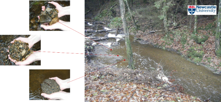
Whilst flow gauging, we also tried out our new GoPro camera. GoPro cameras are rugged and waterproof – perfect for capturing outdoor environments. Whilst flow gauging along the Caw Burn at Gibbs Hill, we tested the GoPro camera underwater. In doing so, we came across some white-clawed crayfish. Videos are a great way to capture the water environment as they do not involve disturbing habitats and species within them i.e. they are non-intrusive methods of data collection. Have a look at the video below… are they what you expected?
10th September 2014 - CIWEM conference, London
CIWEM (Chartered Institute of Water and Environmental Management) held their most recent conference at the University of London on ‘Natural Flood Management: The Evidence Requirements for Wider Delivery’. There were several speakers throughout the day who shared their successful catchment management projects, with case studies from the upper, middle, lower and coastal catchment regions from around the UK. Some of the rural and urban best practice catchment management case studies discussed include:
- The Belford Burn project
- Netherton Burn, Cheviots Future
- Medlock, Manchester
- Sutcliffe Park, South London
- Slowing the Flow, Pickering
- Bowmont and Dee catchments
- Eddleston, Scotland
- Boscastle, Cornwall
- Little Haven Beach, South Tyneside.
If you are a member of the community who monitors the Haltwhistle Burn catchment in some way, then you may be pleased to hear that the most commonly used phrases by nearly all speakers included:
“Science-based evidence”
“Measured evidence is exceptionally valuable”>
“Need more monitoring”
“Continue long-term monitoring”
“Long-term datasets will inform models and provide us with confidence”
“Reduce modelling uncertainty”
A striking fact highlighted from the Belford project (Northumberland) is that natural flood management techniques have been known to reduce flood peaks by up to 30%. Although this is ‘science-based evidence’ which supports the use of natural (or ‘green’) catchment management techniques, there is still very limited information out there to quantify the benefits and prove how useful they are, as oppose to more traditional (‘hard engineering’) mitigation measures.
A representative from the National Farmers Union (NFU) also stressed that we need reliable evidence in order to provide local land owners, farmers and residents with confidence to accept natural catchment management techniques that will, for example, reduce flood risk. This is particularly important to farmers and land owners because natural catchment management techniques, such as natural flood management, often require some land to be put aside upstream of urban areas. This topic has stimulated a debate over the last few years, which was exacerbated during the January/February 2014 floods in Somerset as it is regarded as an alternative to dredging. However, all stakeholders require confidence (evidence) in order to plan, design and implement measures which are intended to have an impact on our water environments. Another interesting finding from the Belford project is that local farmers are regarded as ‘local hero’s’ because they have permitted the use of natural flood management features on their land which meant that Belford did not flood during the following winter.
Some speakers also highlighted the need for visualisation tools, engagement on a local level with the community and that “volunteers play an important role” in catchment management.
The conference finished off with the launch of the Environment Agency’s (EA’s) ‘Working with Natural Processes: Research and Development Framework’. There are a number of reasons for the framework and outcomes anticipated which can be found within the reports published. As part of the framework, research gaps have been highlighted and perhaps the three gaps which the Haltwhistle Burn ‘community-based monitoring and modelling’ project will support include items 1, 5 and 7.
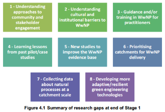
Summary of catchment management research gaps highlighted by the Environment Agency. Source - Working with Natural Processes: Research and Development Framework, Environment Agency 2014.
3rd September 2014 - Weather Words and Qualitative Data
Can we rely on school children to provide a reliable weather diary and help interpret 24hr rainfall totals?
Back in July 2014, 80 school children from Haltwhistle Community Campus took part in various monitoring activities. One of the activities which they completed involved describing, in words, what the weather was like over the past 24 hours. This task also complimented their 24 hour rainfall reading which they took from a plastic rain gauge (which had been left out for a full day 9am to 9am).
By getting local people, who actually live in a catchment of interest, to describe what the weather has been like for the past 24hrs, it helps us to interpret the community-based rain gauge data - which just provides one value for a 24 hour time period. It is extreme weather events (such as a ½ hour heavy rainfall event) which usually cause the most problems to people and infrastructure which is why we need to work out when the rain fell during the 24 hour period.
An average rainfall value (for the time period 9am Monday 14th to 9am Tuesday 15th July) of 1.97mm was provided by the school children. This is a little lower than the 24 hour rainfall total obtained from an automatic tipping bucket rain gauge (one which professional hydrologists use), which gave a value of 2.4mm for the same time period.
These low rainfall values were also accompanied by warm sunny weather. Did the school children pick this up? Find out by viewing the word cloud below which has been used to visually display their answers (hint… the most popular weather words used by the children are larger in size). I think it is fair to say that, collectively, school children can provide a reliable weather diary, especially if they highlight when the rainfall fell.
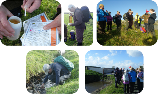
22nd August 2014 - Community-Based Water Quality Monitoring Now Live
Water quality is a way of describing or classifying the health of the water environment. Useful parameters can be monitored to provide an indication of how healthy a pond, lake, stream or river is.
The water environment has many purposes – for example, it sustains aquatic life, it is a source of water and it is a recreational resource. Water quality can also change suddenly as a result of a flash flood event and in rural catchments, farming activities (e.g. fertiliser application) can cause undesirable changes. Poor water quality can also mean that the water body of interest fails the EU Water Framework Directive (WFD) targets. It is sometimes difficult to physically see by eye how healthy a water body is. As a result, a range of physical, chemical and biological parameters can provide an indication of how healthy a pond, lake, stream or river is and there are many well-established monitoring techniques available.
Citizen Science: community-based water quality monitoring along the Haltwhistle Burn:
Training cards have been developed and simple/low-cost monitoring equipment has been purchased. We now also have a couple of volunteers from Haltwhistle who carry out weekly water quality monitoring observations along the Haltwhistle Burn. Along with river level, they are monitoring:
- Temperature
- Algae
- Dissolved Oxygen (DO)
- Nitrates / Nitrites
- Phosphates
- Water clarity
- pH
The more data we have, the more we can find out about the local water environment. If you would like to try some of the water quality #CitizenScience acivities then please visit the 'Volunteer' page http://research.ncl.ac.uk/haltwhistleburn/volunteer/.
Delivered #WaterQuality monitoring kits to members of #Haltwhistle community y'day. More available if any1 interested pic.twitter.com/zx4yUi7hmR
— Haltwhistle Burn (@HaltwhistleBurn) August 22, 2014
18th August 2014 - Parliamentary POST Note “Environmental Citizen Science”
The Parliamentary Office of Science and Technology has recently published a POST Note on “Environmental Citizen Science”. There are some interesting and positive statements, including:
- “Volunteers partner with scientists to answer real-world questions at geographical scales too large for a scientist to study alone”;
- Citizen science is not a new phenomenon, but it is evolving rapidly, becoming increasingly popular and easier to do today due to technology and the internet;
- “Data collected by volunteers plays a crucial role in environmental monitoring”;
- As long as there are quality assurance measures in place, “citizen science can generate high quality data”;
- Community empowerment – identify environmental issues which are backed up by evidence;
- Citizen science positively affects environmental attitude and behaviour
Read the full article here: POST Note 463.
8th August 2014 Weekend of Ex-Bertha hurricane: flooding in the upper catchment (and not Haltwhistle?)
As the ex-Bertha hurricane approached the UK on Friday 8th August, Met Office weather warnings (for heavy rain and wind) were in place for the weekend. Here is a summary of the event for Haltwhistle (most of the information which was collected from the community i.e. a ‘citizen science’ approach):
- A yellow severe weather warning for rain was issued by the Met Office last minute for 8th August for 15:00 onwards
- “Thunderstorm approaching by the sound of it” @ 13:30
- “Heavy showers passing east towards Haltwhistle” @ 14:48
- “Rain started in Haltwhistle about 15:30”
- “Haltwhistle Burn will be taking a hammering – really throwing it down here” @ 16:39
- Flooding at Gibbs Hill area @ 18:30
- No reports of flooding in Haltwhistle itself.
We are not aware of any reports of flooding for Haltwhistle (yet) for this period but a member of the community travelled to the top of the catchment to take a look.. overland flow and transport of sediment was well underway in the Gibbs Hill area of the catchment (immediately downstream / west of Greenlee Lough). Take a look at the photos below. It's great to see how #CommunityMonitoring has spread across the wider catchment - people are not just monitoring what is going on in their back yard. This is a really good research outcome for this #CitizenScience approach and how much it can be relied upon within the catchment management process.
Rainfall totals have not yet been submitted by the community, but when they do, we should have some really useful data showing the spatial rainfall patterns across the catchment during this weekend. If you have some anecdotes, observations, photos or any other information about the weather and river response that over that weekend then please email them to eleanor.starkey@ncl.ac.uk. Remember, it is important that your observations are accompanied by a date and time so that we can piece together what happened. Thank you :)
Community monitoring confirms #flooding #GibbsHill area fri at 6.30pm.bit different to few weeks ago! #CitizenScience pic.twitter.com/t6Jz5WOiki
— Haltwhistle Burn (@HaltwhistleBurn) August 11, 2014
7th August 2014 - Warm and dry weather leaves the Burn low and stable
The summer months are passing by... how is the Haltwhistle Burn responding? Find out using the interactive graph below - with thanks to the river watch members who have collected this data through a citizen science approach (despite river levels remaining constant for nearly two months now!).
Whilst out in the catchment, I've heard some people saying "why continue to monitor on a regular basis when the burn has remained constant and low for so long?" "what's the point.. Haltwhistle isn't going to flood when it is like this". There are many reasons why monitoring is required, e.g:
- It is common during the summer months to experience short (but heavy) periods of rainfall - we need to capture these and determine whether the Burn rises or whether this water is stored higher up in the catchment
- If it does flood following a heavy summer thunder storm, when was it last at low flow? At what time did it start to rise? How much did it rise? If members of the community are out monitoring on a regular basis, we are more likely to capture this type of information.
- Low level = low flow (volume) = Less aeration and holding capacity = less oxygen = higher biological oxygen demand (BOD) = unable to sustain aquatic life.
- Fish are particularly vulnerable to low flow and shallow river levels... they need space to swim!
Please continue to send in your river level data.. it is all useful information.
29/07/2014 Citizen Science in the news... again :)
Great to see so many articles in the news recently about citizen science and the benefits from this type of approach:
- Engagement
- Awareness
- Understanding
- Research-based minds
- Enthusiasm
- Environmental protection
- Lots of data = new knowledge!
- Tackling local problems.
Citizen science in schools boosts pupil engagement and saves the environment http://t.co/z2CTjj5BZL via @guardian
— Haltwhistle Burn (@HaltwhistleBurn) July 29, 2014
"data students gathered proved valuable for scientists, and the students get something out of it"
"For many children, learning about nature is fun because it involves going outside and getting your hands dirty"
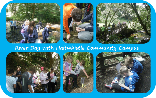
80 school children monitor the Haltwhistle Burn 15/07/2014
The weather stayed dry and the Haltwhistle Bun remained at low level as 80 school children from Haltwhistle Community Campus took part in a ‘river day’. Spilt into groups, the children rotated around a number of activities, including:
- River simulator to look at floods, morphology and the impacts of different flood defences
- Invertebrate sampling
- Transects and flow monitoring using oranges as floats
- A walk up to Broomshaw Hill footbridge to take weather, rainfall, river level and water clarity observations
- Submit observations using an Android App developed by Newcastle University
This event provided the research project with ‘mass data’ and successful engagement with the younger generation and knowledge transfer.
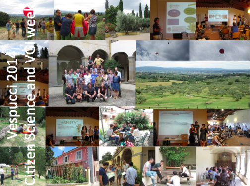
7th - 11th July 2014 “VGI and Citizen Science: Engaging, Creating and Understanding”
Eleanor recently attended the Vespucci Initiative (summer school) organised by COST ENERGIC Action (vgibox.eu). Based in Fiesole (a beautiful spot on the hillside which overlooked Florence, the Tuscany region of Italy), the weeks seminars, activities and discussions were based around VGI (Volunteered Geographical Information) and Citizen Science (knowledge production). To be more specific, the following topics formed the bulk of the programme:
- Participants needs, motivation and engagement (for citizen science)
- Analysis and visualisation of data collected
- Dissemination and data sharing
- Data management
- Ethical and social considerations
- Economic and practical considerations.
As a citizen science facilitator for the Haltwhistle Burn river watch programme, the above topics were extremely interesting. Key points and tips taken away from #Vespucci2014 include:
- Engaging on a local level and ensure citizen science is related to a relevant topic
- Constantly feed your findings back to the community – use effective visualisation tools
- Citizen science = knowledge production = new power
- Citizen scientists can monitor things which are too difficult for a sensor or autmatic system to capture properly
- Citizen Science is not just about knowledge production... the project can also have various social benefits
- Using volunteers to collect data: we can gather information over a wide area (spatial coverage)
- Regardless of data quality, remember that “any data is better than no data”
- Credibility of citizen science observations: ensure protocols are in place to limit error and uncertainty and create metadata (this means creating information or data to explain the data!)
- Sustainability and legacy of a citizen science (or VGI) project – will volunteers carry on the process into the future?
The Haltwhistle Burn river citizen science project was also shared with the course facilitators and participants (this stimulated lots of encouraging feedback J), all of whom are involved in a diverse range of citizen science and VGI projects. For example, Public Labs, eBird and Atrapael Tigre which are based in a number of counties around the world.
Sharing the Haltwhistle Burn case study at the Newcastle University PGR Conference 3rd-4th July 2014
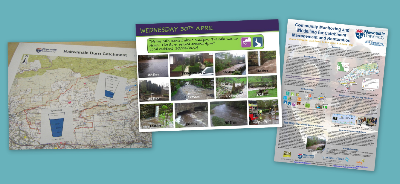
A community monitoring and modelling approach has been shared at the Newcastle University Postgraduate Conference this week, including the Haltwhistle Burn work. Take a look at the poster which was on show..
Community Monitoring and Modelling poster July 2014
PDF 1,995Kb
A summary of the project including aims, methodology, the Haltwhistle Burn case study site and progress to date.
River Watch Meeting - 26th June 2014
The summer river watch meeting took place in Haltwhistle on the evening of 26th June. Members of the community were able to find out more about traditional and community-based monitoring within their local water environment. Datasets collected over the period of January-June 2014 were presented by Newcastle University, with focus on the two recent flash flood events - 30th April & 10th/11th May 2014. It was concluded that rainfall and river levels are extremely variable across the catchment... we need local data to capture this. Without existing monitoring being carried out by members of the community during the recent flood events in Haltwhistle itself, we would have never known how intense and localised they really were. Thank you to everyone who shared their photos, videos, anecdotes and observations so far – it is extremely valuable information!
The local community also had the opportunity to discuss community-based monitoring techniques (simple, low-cost citizen science approach). If you are interested in monitoring (whether this is daily, weekly, monthly or as a one-off event) then please email eleanor.starkey@ncl.ac.uk.
If you missed the event, take a look at the images and download the presentation slides (pdf version) below…
River Watch Meeting slides 26th June 2014
PDF 4,361Kb
Slides to keep you updated on the Haltwhistle Burn project.
Community successfully monitors river levels and rainfall
Members of the Haltwhistle community have been observing river levels and rainfall for many months now. Hover over the graph below to find out how the Haltwhistle Burn has responded following rainfall. Flash flood events occurred on 30th April and 11th May... how much did it rain?
Wednesday 30th April 2014 - Haltwhistle hit hard by an extremely localised flash flood event.. and again on Sunday 11th May!
30th April 2014:
Reports from the local community suggest that heavy rainfall hit the Haltwhistle area at approximately 1500hrs which resulted in fast flowing watercourses and overland flow in key areas. Four fire engines were called out to areas including Castle Hill and The Mart. A member of the community who lives in Haltwhistle manually measures rainfall in their back garden and has confirmed that 41mm of rainfall fell on Wednesday 30th April 2014. The localised nature of this flash flood event is emphasised by the fact that Gibbs Hill area only received 16.7mm rainfall, Blenkinsop Hall had 17.2mm and Brampton had 1.2mm rainfall.
Photos and videos have been collated and are displayed in the Flickr photo album below. They have been ordered by date & time so you can see how the flood event developed and where the impacts were. You can also view these photos and videos on a map here.
Sunday 11th May:
A thunder storm hit the Haltwhistle area on the afternoon of Sunday 11th May. This caused further flooding in areas including Newholme Avenue, The Mart, Willia Road and Shield Hill. Water quality (as a result of erosion and sediment transportation) left the Haltwhistle Burn and some smaller tributaries looking particularly discoloured. Did you notice this too?...

As with the 30th April 2014 flood event, photos and videos from the 11th May 2014 flood event have been collated and are displayed in the Flickr photo album below. They have been ordered by date & time so you can see how the flood event developed and where the impacts were.
Do you have any of your own videos, photos or other observations of the Haltwhistle flood event (including descriptive accounts of what happened, arrival or rainfall, how long it rained for etc)? If so then please get in touch by either:
- email (eleanor.starkey@ncl.ac.uk);
- Submitting your data using an online form within the Community Hub here;
- Twitter - using the hashtags #Haltwhistle, #FlashFlood or #HaltwhistleBurn and send to @HaltwhistleBurn.
Why is it important to collect evidence before, during and after flooding from members of the local community? Members of the local community live within the catchment and often have detail accounts or evidence of flood events. Flash flood events in particular happen so fast that engineers and catchment managers do not have time to travel to the site. This valuable information can help support future catchment management activities and inform the rest of the community what is going on in their own area.
Floods in the media..
- The Journal (article published online 01/05/2014) 'Haltwhistle residents call for action following the latest flood'
- Hexham Courant (article published online 07/05/2014) 'Flash flood swamps Haltwhistle homes'
- West Tynedale Matters (article published 18/06/2014) '£1m needed to tackle town's flash flooding'
15/04/2014 Haltwhistle Burn 'Total Catchment Approach' wins the Partnership category in the England River Prize
Haltwhistle Burn: a 'total catchment' approach CRF project led by Tyne Rivers Trust has won the Partnership category in the England River Prize run by the Environment Agency, River Restoration Centre and WWF.
The project has now been short-listed for the overall final which will be announced during the 14th Annual River Restoration Centre Conference in Sheffield (7th May 2014). For more information please follow this link bit.ly/1jEHWVH.
Well done to everyone working on the project.
#HaltwhistleBurn 'Total Catchment Approach' project has won England River Prize Partnership Category http://t.co/kJY1j27GCg @TyneRiversTrust
— Haltwhistle Burn (@HaltwhistleBurn) April 14, 2014
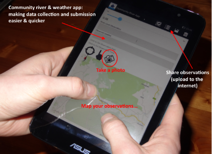
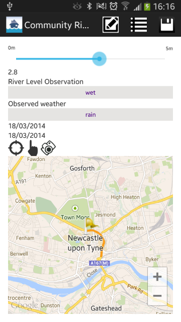
28/03/2014 “Community River App” preview
An Android app has been developed as part of the project and is almost ready for use. The app will allow members of the local community to collect and submit weather and rainfall observations. If you are interested to hear more or would like to trial the app then please get in touch (eleanor.starkey@ncl.ac.uk). The app interface will look like this:
17th to 21st March 2014 - NERC Multidisciplinary Soil and Water (CATSCI) course
Eleanor had a great week in the Eden catchment - interesting material was covered by Lancaster University during the NERC Soil and Water CATSCI training course. Delegates were keen to hear more about the Haltwhistle Burn project. Eden Rivers Trust held a workshop on their ‘Save the Eden’ campaign which is heavily orientated around (and involves) local communities. To find out more about the plan, see their manifesto.
27th Feb 2014 - Successful River Watch meeting!
A very good turnout for this event and it was great to see how much enthusiasm and care everyone has for the Haltwhistle Burn catchment.
"I enjoyed the evening and I am impressed by the depth and complexity of the research project" Haltwhistle resident, February 2014.
During this meeting the community was introduced to the concept of ‘community monitoring’ and ‘citizen science’. Community members who attended were asked to provide their monitoring preferences and capabilities. Over the months of March and April 2014 the group will be provide with low-cost monitoring equipment (e.g. manual rain gauges, pH strips, thermometers and float gauges) and relevant training guides so that we can begin to collect information about the Haltwhistle Burn Catchment.
So far we have a number of people in the lower parts of the catchment wanting to take part in monitoring activities. We still need volunteers for locations north of the Military Road and Hadrian’s Wall. Do you have any ideas or know anyone who can help..?
If you would like to view a copy of the slides presented during the evening, please download below:
Presentation slides from River Watch meeting 27th February 2014
PDF 3,353Kb
Introducing the Haltwhistle community to community-based monitoring and citizen science.
27th February 2014 - River Watch Meeting (Comrades Club, Haltwhistle, 7pm)
The next River Watch meeting will be held on 27th February 2014 at 7pm. This event is open to anyone who would like to know more about the community monitoring activities proposed for the Haltwhistle Burn catchment.
Come along to listen about and see a few examples of monitorng techniques (such as rain gauges) and tools which are being developed for data submission. Download the meeting leaflet below.
27th Feb River Watch leaflet
PDF 381Kb
River Watch Meeting - 27th February 2014 meeting leaflet
11th February 2014 - South Tyne Wildlife Group
The latest from the Haltwhistle Burn CRF and PhD project was presented to the South Tyne Wildlife Group on the evening of 11th February 2014. Presentation slides can be found below..
South Tyne Wildlife Group - presentation 11th Feb 2014
PDF 1,388Kb
A copy of all the slides presented by Eleanor Starkey during the South Tyne Wildlife Group meeting 11/02/14
January / February 2014 – Progress Update
The Haltwhistle Burn project has progressed well since the start of the New Year. Highlights include:
- Sharing best practice at the January 2014 Tyne and Northumberland Catchment forum.
- A draft community monitoring plan has been developed. This plan will be shared with the community during a River Watch meeting at the end of February. Please contact Eleanor Starkey (eleanor.starkey@ncl.ac.uk) for further information and/or if you would like to attend.
- A member of the Haltwhistle Community has volunteered to take daily river levels in the Townfoot area. To do this Pat takes a picture of the river level gauge board and tweets it to @HaltwhistleBurn. Although this is just a trial (before the main monitoring plan is in place), it is a massive step forward and a positive result for the community monitoring aspect of the PhD project.
- Six automatic water level recorders and one automatic rain gauge have been installed across the catchment. There are still a few more pieces of equipment to install, all of which should be in place during February.
December 2013 / January 2014 - monitoring equipment
An order for hydrological monitoring equipment has now been placed with EML. We will therefore be installing the equipment at various locations across the catchment in December / January, including rain gauages and water level recorders. This will provide the research project with some baseline data to work with before any catchment intervention measures are proposed. Catchment users will also find this data useful and will be able to view everything on this website once it is up and running. Watch this space for updates!
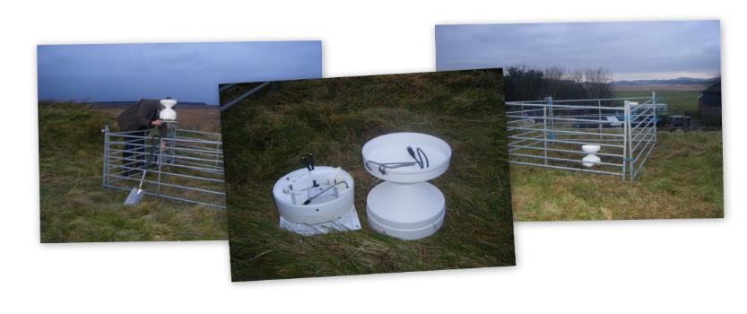
November 2013 - data collection phase
This is the 'data collection phase' of the project. A network of monitoring equipment (such as rain gauges, telemetered water level recorders etc) will also be installed at key locations within the Haltwhistle Burn catchment. This will provide the research project with some baseline data to work with before any catchment intervention measures are proposed.
@HaltwhistleBurn has now been launched on Twitter! Please encourage others to follow.
October 2013 - engagement with the Haltwhistle Community
On 3 October 2013, Newcastle University and Tyne Rivers Trust hosted a workshop with the Haltwhistle Community. This informal meeting was designed to brief the community on the research being carried out within their catchment and allow everyone to share their knowledge. This event was a great success and thank you to everyone who attended - we collected some very interesting and useful information about the Haltwhistle Burn Catchment. The photographs below show the community taking part in a participatory mapping ('P-GIS') approach..
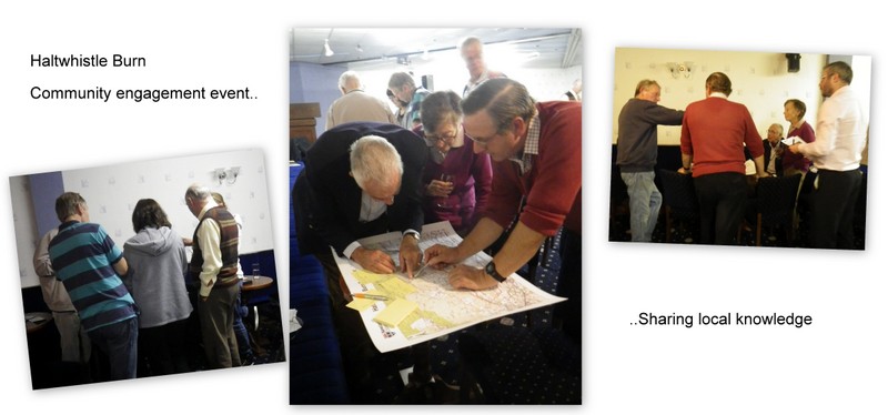
If you missed this community event you can view the briefing leaflet and PowerPoint presentation by clicking on the links below.
3 October 2013 meeting - slides presented to the community
PDF 1,804Kb
(click above to download)
3 October 2013 meeting - briefing leaflet.
PDF 234Kb
(click above to download)
No. webpage visitors since 07/10/2014:
