ROSES STUDY SITES
 The Miocene
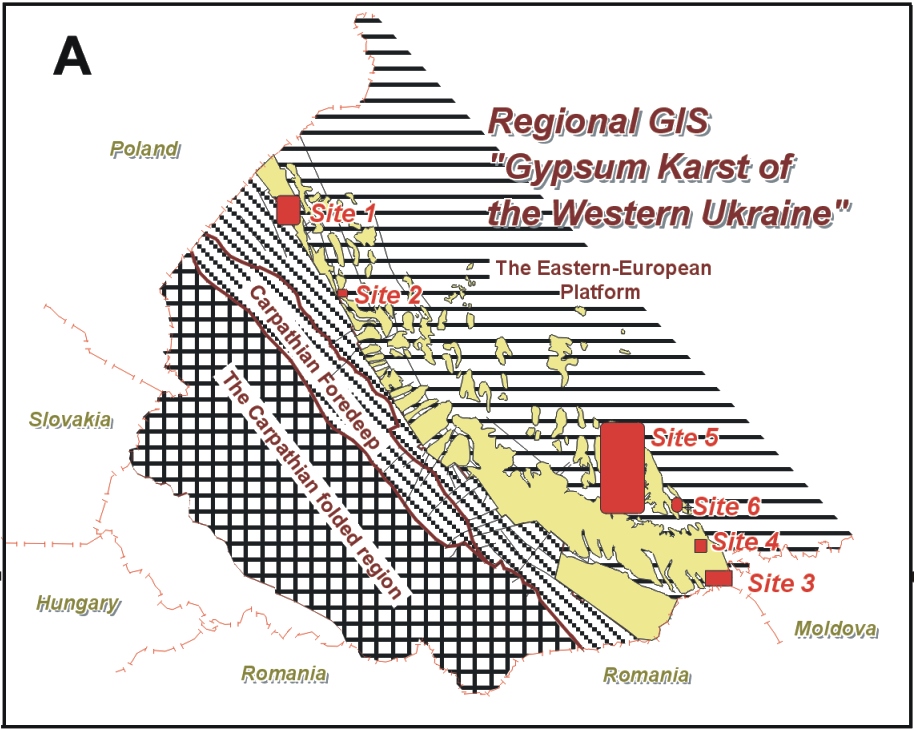
gypsum sequence in the Western Ukraine extends throughout an area of more
than 20,000 km2. Gypsum stretches from the northwest to southeast, from the
border with Poland to the Romanian border for about 300 km as a belt ranging
from less than 10km to as much as 80 km in width . In terms of tectonics,
the study region occupies the southwestern edge of the Eastern European platform,
the transition zone between the platform and the Carpathian foredeep. Sulphates,
mainly anhydrites, are also present in the foredeep but they reside at
considerable depth, beneath several hundred metres of clays and are not
considered here. Six sites are selected through the region for detailed
characterisation in order to represent various karst settings.
The Miocene
gypsum sequence in the Western Ukraine extends throughout an area of more
than 20,000 km2. Gypsum stretches from the northwest to southeast, from the
border with Poland to the Romanian border for about 300 km as a belt ranging
from less than 10km to as much as 80 km in width . In terms of tectonics,
the study region occupies the southwestern edge of the Eastern European platform,
the transition zone between the platform and the Carpathian foredeep. Sulphates,
mainly anhydrites, are also present in the foredeep but they reside at
considerable depth, beneath several hundred metres of clays and are not
considered here. Six sites are selected through the region for detailed
characterisation in order to represent various karst settings.
Geological setting
Most Miocene rocks along the platform margin rest unconformably on Cretaceous strata, which include terrigenous and carbonate sediments, mostly marls and sandstones, together with detrital and argillaceous limestones. The Miocene succession comprises deposits of Badenian and Sarmatian age. The Lower Badenian unit, beneath the gypsum, includes mainly carbonaceous, argillaceous and sandy beds (50-90 m thick) adjacent to the foredeep, and these grade into rocks of calcareous bioherm and sandy facies (10-30 m thick) towards the platform interior . Overlying the gypsum unit is a layer of micritic and cryptocrystalline limestone, ranging from several tens of centimetres to more than 25 m in thickness.
The gypsum occurs as a single bed 10-40 m thick through the most of the region, although it is variable in structure and texture. In the Podol'sky area it includes three horizons, which, in ascending order, contain crypto- and microcrystalline massive gypsum, bedded microcrystalline gypsum and mega-crystalline gypsum. Gypsum within the upper horizon displays large spherulitic structures (Klimchouk, Andrejchuk & Turchinov, 1995). Close to the foredeep, the gypsum is more homogeneous and aphanitic in texture, and the anhydrite content of the sequence increases. There are sporadic thin interbeds of carbonate and clay.
The Miocene succession is overlain by late-Pliocene and Pleistocene glacio-fluvial sands and loams in the north-west section of the gypsum belt (Site 1 and 2), and by Pliocene and early Pleistocene sand and gravel alluvial terrace deposits (Site 5 and 6). Many buried valleys, of early to mid Pleistocene age, are entrenched 30 to 50 m into the Kosovsky and Sarmatian clays and, locally, into the upper part of the Tyrassky Formation.
 Geomorphology
and neotectonics
Geomorphology
and neotectonics
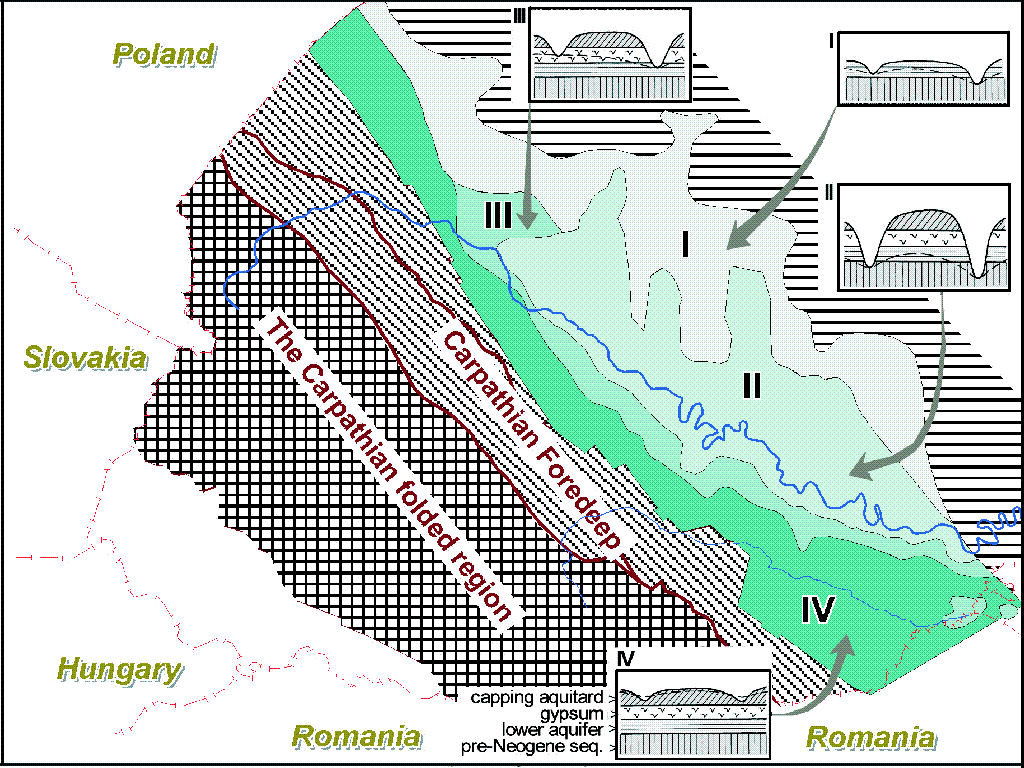
The present geomorphological settings, the distribution of the Miocene formations and the levels of their denudation were formed in response to differential neotectonic movements experienced by the region in relation to activity in the adjacent Carpathians and the foredeep. They have resulted in various parts of the territory displaying different types (stages) of intrastratal karst, from deep-seated, through subjacent, to entrenched (see conceptual karst settings). These conditions vary in a regular way from the platform interior towards the foredeep (Andrejchouk, 1988; Klimchouk et al, 1985; Klimchouk & Andrejchouk, 1988).
Hydrogeological settings, karst types and subsidence potential
In hydrogeological terms, the region represents the southwestern portion of the Volyno-Podolsky artesian basin (Shestopalov, 1989). Sarmatian and Kosovsky clays and marls provide an upper confining sequence. The original aquifers comprise the sandstone interbeds in the lower part of the Kosovsky Formation, the Ternopol'sky Beds (lithothamnion limestones) and the limestone bed of the Tyrassky Formation (all above the gypsum), and the Lower Badenian sandy carbonate beds (below the gypsum). The Lower Badenian sandy carbonate forms the major regional aquifer. The hydrogeologic role of the gypsiferous unit has changed with time, from initially being an aquiclude, intervening between two aquifers, to a karstified aquifer with well-developed conduit permeability. Underlying Cretaceous sediments have variable properties across the area. Regional flow is from the platform interior, where confining clays and the gypsum are largely denuded, toward the large and deep Dniester Valley and the Carpathian foredeep. The main factors that determine contemporary hydrogeologic conditions are the differences in the depths of the gypsum, the level of areal denudation of the land surface and the depth of erosional entrenchment by the major valleys. Four roughly sub-parallel zones are distinguished: the first one represents the area where the gypsum is entirely removed by denudation whereas other three are characterized by different types of gypsum karst.
Zone 1: denuded karst
The Tyrassky Formation and the clay sequence are denuded entirely so that the permeable Lower Badenian sediments are exposed at the surface. This zone is immediately adjacent to the 4th zone (artesian setting) in the north-west of the region and represents the marginal recharge area for the latter.
Zone 2: entrenched karst.
In the second zone the Miocene rocks and underlying formations are deeply entrenched by valleys of the major northern tributaries of the Dniester, separated by wide inter-valley plateaus where the gypsum and clay overburden remain largely intact. The Miocene formations are almost entirely drained and only in the central parts of the inter-valley plateaus do the units beneath the gypsum contain unconfined underground water. In some tectonic blocks the water table extends upwards into the lower part of the gypsum (e.g. Ozernaya Cave) with multi-year fluctuations that range from 3 to 5 m. Huge maze cave systems in the gypsum are known here: they are relict, having formed under former artesian conditions. Modern dissolution is restricted to the lower part of gypsum, where the water table is present at rare points of focused vertical percolation (where vertical dissolution pipes develop) and along linear underground streams that are fed via swallow holes that receive periodic surface flow. At present, focused point recharge is the main recharge mode of the Miocene aquifer in this zone. Doline density increases locally where the capping clays are removed, as within old, high, river terraces. Recent subsidence is rare. Discharge takes the form of springs flowing from the unit beneath the gypsum, or from the underlying Cretaceous formations.
These conditions typify an intrastratal entrenched karst, according to the classification introduced in Section 2.1. They are characteristic of the area within the interior of the platform, to the northeast and north of the Dniester Valley, and for the Podol'sky area in particular. A narrow area on the southern bank of the Dniester Valley also lies within this zone, but this grades into the 3rd zone.
Zone3: subjacent karst.
To the southwest and south of the Dniester Valley the depth of the gypsum formation increases, while the depth of erosional entrenchment diminishes. The narrow (3 to 15 km-wide) 3rd zone is located between the Dniester and Prut Valleys, where the water table lies within the gypsum or locally within the overlying unit. Floors of minor valleys lie above, or are entrenched into, the karstified gypsum unit, causing diverse karst features to develop, with intermittent streams, swallow holes, ascending karst springs and estavelles. Recent collapse and subsidence dolines are common, as the water table and localized streams intensify breakdown processes in the gypsum by active dissolution and erosional removal of cave fills. During 1998, observations were carried out on the Dankivtsy site (Site 4) where a 22 m deep collapse shaft formed suddenly on January 11 and opened a fragment of a large cavity in gypsum (Figure 3.15). Most of the cave passages are inundated; the water table is located just 2 m below the top of the gypsum. As the shaft is in the clayey sequence, it progressively filled up during the year due to mass wasting of the walls: at the end of October it was a 6m deep bowl-like sinkhole.
Cave systems inherited from the confined stage are accessible only as small fragments due to filling and high water table position, but drilling data and observations in the neighbouring second zone indicate their wide presence. Relatively small linear through-caves are also common, and their origin is attributed to contemporary conditions.
In general, the groundwater flow in the Miocene aquifer is directed northwards to the Dniester Valley, and south-southwestwards to the Prut Valley. Flow becomes confined in the latter direction, within the fourth zone, where the Tyrassky Formation lies at an even greater depth beneath the increasing thickness of clayey overburden. The 3rd zone represents subjacent karst conditions, grading locally into early phases of entrenched karst.
Zone 4: deep-seated and subjacent karst
The fourth zone stretches along the boundary between the platform and the foredeep. Within this zone the formations comprising the Miocene aquifer lie at depths of 30-40 to 80-100 m beneath the Kosovsky clays, which are cut in part only by shallow erosional valleys, so that flow is confined.
Speleogenesis
Fourteen large caves over 1 km in length are known in the region. Most of these caves are within the second zone (entrenched karst). Two other large caves, Zoloushka and Bukovinka, are in the Bukovinsky sub-region, near the Prut River. This is as area of artesian flow within the Miocene aquifer system (fourth zone) where the upper part of the gypsum has been entrenched and drained especially within locally distributed uplifted blocks. Because of this uplift, water table conditions prevail in the gypsum unit within this area. In the area of Zoloushka Cave the upper storey of the cave has been drained by additional water table lowering, thus facilitating access for exploration.
All the large gypsum caves in the region are mazes developed along vertical and steeply inclined fissures and are arranged into laterally extensive networks. Aggregating passages form lateral two-to four-storey systems that extend over areas of up to 1.0 km2. Such areas, termed here cave fields, are defined by drawing an arbitrary boundary closely comprising a cave.
Optimisticheskaja Cave is the longest gypsum cave, and the second longest cave of any type, known in the world, with more than 200 km of surveyed passages. The region contains the five longest known gypsum caves in the world, accounting for well over half of the total known length of gypsum caves on the Earth. By area and volume the largest caves are Ozernaja (330,000 m2 and 665,000 m3) and Zoloushka (305,000 m2 and 712,000 m3), followed by Optimisticheskaja Cave (240,000 m2 and 500,000 m3). The absolute parameters of the cave systems change as speleological exploration progresses. Specific parameters are more informative. Specific volume (the cave volume/length ratio) characterizes "voluminosity" of cave passages in a certain cave system. For the caves of the region this feature ranges from 1.6 (Gostry Govdy Cave) to 8.0 (Zoloushka Cave) m3/m; the average for the region is 3.84 m3/m.
Passage network density is characterized conveniently by use of the ratio of cave length to the unit area of a cave field (km/km2). This parameter varies for the region from 118 (Slavka Cave) to 321 (Bukovinka Cave) km/km2, with the average value of 200 km/km2. The availability of detailed morphometrical data on caves and the host rock bodies allows the calculation of coefficients of karstification of the gypsum stratum both in terms of area and volume (fractions of total area and volume of the rock within a cave field, occupied by passages). The former parameter varies from 17% to 71% (Table 1), the average value is 37%. The volumetrical coefficient of karstification varies from 2-3% to 12%, with an average value of 5%. This latter figure is consistent with typical specific yeild values of only a few percent found in studies of karst hydrology (e.g. Sauter, 1992; Younger et al., 1997).
Maze caves in the region developed (and are presently still developing in the 4th zone) under confined conditions, due to upward transverse groundwater circulation between the pre-existing sub-gypsum and supra-gypsum aquifers (Klimchouk, 1990, 1992; see Section 2.1 for a conceptual model). Such flow patterns are characteristic of potentiometric low areas, related to topographic lows (valleys) that commonly coincide with zones of enhanced fluid conductivity created within the capping clays by tectonic or stratigraphic discontinuities. Overall discharge from artesian aquifer systems occurs in such areas.
The Western Ukrainian maze caves provide the most outstanding and unambiguous evidence for the transverse artesian speleogenetic model. The artesian speleogenesis in the Podol'sky sub-region took place during the Late Pliocene through Early Pleistocene when the overall maze structure of the caves was established. Breaching of artesian confinement and further incision of the valleys during the Middle Pleistocene caused substantial acceleration of groundwater circulation within the Miocene artesian system. The majority of cave growth, as well as subsidence formation probably occurred during this transitional period. Further widening of passages occurred where the water table was established in the gypsum for a prolonged time,. Eventually, with the drop of the water table below the lower gypsum contact, cave systems became entirely fossilized. Cave development under confined conditions continues today within the fourth and, partially, in the third zone.
The hydrodynamic and hydrochemical conditions of cave development during the mature and active stage of artesian speleogenesis can be illustrated by examples from northwest of the gypsum belt where confined conditions still prevail (Sites 1 and 2). Groundwaters entering the gypsum from below (from the sub-gypsum sandy-carbonate aquifer) have TDS contents ranging from 0.4 to 0.6 g/L, and are very aggressive with respect to gypsum, being able to dissolve it at rates ranging from 2.48 to -25.57 mm/yr. Water chemistry and dissolution rates in cavities within the gypsum vary substantially, depending upon the cave system configuration (the actual flow path within the cave system) and flow velocity. The TDS content ranges from 1.3 to 2.1 g/L, and dissolution rates range from 0.16 to -3.46 mm/yr. The above enlargement rates are obtained (Klimchouk et al., 1996) from areas where the flow conditions have been influenced by quarrying activity, that may approximately correspond to the late artesian stage when initial breaching of confinement occurs. The rates during the main artesian stage are perhaps of the order of the lowest reported values.
Under conditions of transverse circulation in an artesian system, all available fissures in the gypsum, which hold similar positions within analogous flow paths, will enlarge at comparable rates because of the availability of aerially dispersed aggressive recharge from below and suppressed hydraulic competition. This behavior generally favors the development of maze cave structures, but the actual conduit arrangement in any situation will depend upon the initial fissure pattern in a given locality.
Infrastructure settlements & development
The region is quite densely populated. Rural population prevails; its density in some areas exceeds 100 individuals/km2. There are some large cities such as Lviv (population 800,000), Ivano-Frankivs'k (220,000), Chernivtsy (260,000). The region has intensive agriculture and related processing industries. Other main industries developed in the region are machinery construction, light industry, mining and ore processing and chemical industry. Within the gypsum area native sulphur, gypsum and clay for the cement industry are extensively quarried, resulting in strong impacts on karst, and intense induced subsidence developments (Sites 1, 2 and 3). Such impacts are particularly marked where opencast mining within the 3rd and 4th zones is associated with groundwater abstraction from the Miocene aquifers.
There is a moderately well-developed transportation network in the region. The density of railways is higher than the average for the country. Some major highways and railways traverse the region, connecting Ukraine with Central Europe. There are recorded instances of induced subsidence damage along the railroads.
Summary
The Western Ukraine contains one of the largest gypsum karst areas in the world. Differential neotectonic movements resulted in various parts of the region displaying different types (stages) of intrastratal karst, from deep-seated, through subjacent, to entrenched. Subsidence hazards are most relevant to the zone of subjacent karst. Opencast mining associated with groundwater withdrawal from the Miocene aquifers imposed massive impact on karst and induced an intense subsidence development in many localities.
Huge relict maze cave systems have been explored in the zones of entrenched and subjacent karst, five of which are currently the longest known gypsum caves in the world. They account for well over half of the total length of gypsum caves that has been explored around the world. Their study gives a unique opportunity to develop and test speleogenetic concepts as well as to reveal mechanisms of subsidence formation.