News & Events
The SPOT World Heritage Archive
Documenting Landscape Change with imagery from the SPOT World Heritage Archive
Landscape changes can be non-linear and non-uniform. They aren’t always visible at a single point in time, and they occur at different scales and speeds. This makes the impacts of historical changes in land use and environment hard to assess from just one or two satellite images, which is one reason we try to incorporate as many data sources as possible into our landscape change assessments.
SPOT satellite imagery is one source of multi-temporal, high resolution visual information that helps us understand natural and human-driven processes of landscape change, and how these have impacted modern communities, environments and ancient archaeological sites. The SPOT programme, developed by the Centre national d'études spatiales (CNES), recorded imagery of the earth between 1986 and 2015 at spatial resolutions of up to 2.5m. The CNES has now made SPOT imagery freely available through its SPOT World Heritage portal.
SPOT data play a valuable role in our analysis of the events leading up to the present landscape, providing a record of historical environmental conditions and former iterations of land use now erased or obscured by human and environmental change. Imagery at up to 10-meter spatial resolution, available for the late 1980s and 1990s, gives us general information about archaeological sites, palaeoenvironmental features such as ancient Nile River channels, and larger landscape processes such as sand dune movement and agricultural expansion. 2.5-meter imagery from the early 2000s through 2015 helps us identify previously unrecorded archaeology, document changes to individual archaeological features and better understand planting processes and agricultural field constructions.
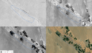
One example of this is change at the archaeological site P17, on the bank of an ancient Nile palaeochannel in our study area. Surveys carried out in the late 1990s recorded close to 300 mound features there, along with burnt mounds, other structures and artefact scatters, a figure that corresponds closely with a visual assessment of historical CORONA satellite imagery from 1969.
Based on the available imagery, changes to ground surface between 1969 and 2026 have impacted roughly 90% of the site’s visible archaeological features. The 10m SPOT layers indicate that agricultural activity increased in the late 1990s and accelerated in the mid 2000s. Between 2005 and 2011, the higher-resolution 2.5m imagery depicts significant impacts to the mounded areas of the site and surrounding landscape in detail. Other satellite imagery from 2026 indicates that the surface components of perhaps fewer than 30 mounds remain.
Our recent research at this site indicates that many of these mounds may have been created thousands of years ago, as the nearby palaeochannel began to dry. Combining earlier work in the region with our own analysis, we think many of the mounds might relate to water procurement. Gathering more information about them may help us better understand how water was managed in the past as the availability of this important resource decreased. The SPOT imagery provides important information about the former locations and sizes of mound features no longer visible on the ground surface, allowing us to reconstruct the site area with great accuracy and potentially investigate former mound locations for any remaining subsurface archaeological material.
SPOT imagery products can be downloaded at no cost through the SPOT World Heritage Archive data site and geocoded using the SWH-2A Carto Service and/or your favourite GIS application. QGIS (https://www.qgis.org/) and SNAP (https://step.esa.int/main/download/snap-download/) are good places to start.
Merci @CNES!
SPOT images displayed in this post were acquired by CNES's SPOT World Heritage Programme.
CORONA imagery was acquired from the U.S. Geological Survey & the CAST CORONA Atlas
 1997 (SPOT) 2005 (SPOT) and 2026")
Last modified: Fri, 26 Jun 2026 16:11:22 BST