News & Events
40 years of landscape change in the Dongola Reach
How are past and present resources being impacted by landscape change in the Dongola Reach, and what will the resulting future hold for people and their landscapes? Project AHLAN is using publicly available remote sensing data to find out!
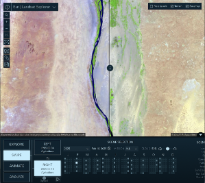
In our project area we can see a lot of agricultural development and sand dune movement, which have impacts on local ecologies, ancient sites, aquifers and modern communities alike. A change detection analysis based on NASA Landsat images from February 1985 and January 2025 indicates that areas of agricultural activity alone increased by nearly 200 km2, in many cases along ancient palaeochannels of the Nile, where there is also a lot of documented archaeological material. Sand dune movement has an impact on the visibility and preservation of archaeological sites, and can also be a threat to modern communities and their livelihoods. As the dunes move across the landscape, they cover and uncover archaeological sites and can be hazardous to modern communities and agriculture.
We can also see that agricultural practices are changing, with the development of large high productivity centre-pivot agricultural plots beginning in the early 2000’s in addition to the familiar mosaic of smaller rectilinear field systems. Agricultural irrigation has changed too, as it has become easier to install well systems which can draw water from relatively shallow aquifers that often provide a more reliable flow of water in comparison to Nile-fed irrigation canals. This can be seen in the expansion of agricultural systems where no surface transport irrigation is present.
Did you know that you can use cool tools like ESRI’s Landsat Explorer to easily investigate landscape change over large areas? Using processed data from NASA’s freely available Landsat archive, you can explore images from over 40 years of Landsat missions in various band combinations to see how humans and environmental processes have transformed landscapes all over the world!
Thanks to NASA & the USGS for collecting and making this information available for free, for everyone.
Last modified: Wed, 25 Mar 2026 18:14:09 GMT