News & Events
Earthquake Reconnaissance Data Sources, a Literature Review
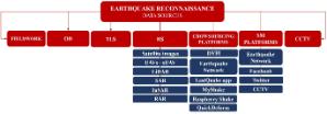
We announce the publication of the review paper entitled:'Earthquake Reconnaissance Data Sources, a Literature Review'. This paper aimed to identify state-of-the-art data sources for building damage assessment and provide guidance for more efficient data collection. It was reviewed 39 articles that indicated the sources used by different authors to collect data related to damage and post-disaster recovery progress after earthquakes between 2014 and 2021. The current data collection methods identified were grouped into seven categories: fieldwork or ground surveys, omnidirectional imagery (OD), terrestrial laser scanning (TLS), remote sensing (RS), crowdsourcing platforms, social media (SM) and closed-circuit television videos (CCTV). In the case of RS, data sources identified were satellite images, Unmanned Aerial Vehicles (UAVs) and Small Unmanned Aerial Vehicles (sUAV), Light Detection and Ranging (LiDAR), high-resolution synthetic aperture radar (SAR) and Interferometric Synthetic-Aperture Radar (InSAR).
It was concluded that modern reconnaissance missions cannot rely on a single data source. Different data sources should complement each other, validate collected data or systematically quantify the damage. The recent increase in the number of crowdsourcing and SM platforms used to source earthquake reconnaissance data demonstrates that this is likely to become an increasingly important data source.
Reference:
Contreras, D., Wilkinson, S., & James, P. (2021). Earthquake Reconnaissance Data Sources, a Literature Review.Earth, 2(4), 1006-1037. doi:10.3390/earth2040060
This review paper was showcased by Preventionweb, the global knowledge-sharing platform for disaster risk reduction and resilience developed by United Nations Office for Disaster Risk Reduction (UNDRR):https://www.preventionweb.net/publication/earthquake-reconnaissance-data-sources-literature-review
Last modified: Thu, 02 Dec 2021 09:20:12 GMT