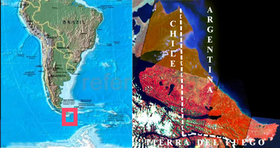
newcastle university newcastle university website civil engineering and geosciences website newcastle university website civil engineering and geosciences website newcastle university civil engineering and geosciences

home

project

consortium

focus areas

project flyer

deliverables

capacity building documents

papers

poster

partners secure

epic force

Evidence-based Policy for Integrated Control of Forested River Catchments in Extreme Rainfall and Snowmelt

focus areas • Argentina

Andean-Patagonic eco-region

Location

Focus basins are located in the province of Tierra del Fuego.

Tierra del Fuego is an island located in the extreme south of Argentina and Chile separated from the continent by the Magallanes Straight.

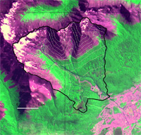
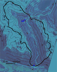
The focus basins are located in the Mountain zone of Tierra del Fuego island.
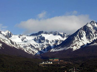
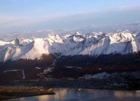
Mountain basins occupy the area between Fueguin Andes Mountain Range and Beagle Channel. They present glacio-snowy hydrological regime, soils of scarce depth and eventual slides and avalanches.

The stream network presents high density, short paths, strong slopes and moderated flows. Runoff is mainly regulated by seasonal snow, mires, mountain range detritus storages and contributing glaciers. There is also another type of storage such as lakes, which genesis is associated with glacier and periglacier processes.   

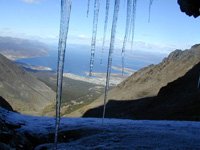
Seasonal snow is the storage with higher regulation capacity; it’s possible to appreciate snow accumulation in the whole basin but it has more important development and stability at the high levels of the basin.

These basins present some typical features related with the austral andean mountain range environment.

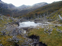
Predominant vegetation in mountain basins is mesophile forest in the following varieties: caducifolias Nothofagus Pumilio (lenga),  Nothofagus Antártica (ñire) and perennifolia Nothofagus. Betuloides (guindo o coihue from magallanes) (Roig, 1998) often associated with Drimys winteri (Canelo). The superior forest boundary is at 600 m altitude, but it may vary around ± 100m depending on the slope sun exposition and on the sea proximity, which attenuates thermal oscillations (Puigdefabregas et al, 1988).

Forest log activities in the region are becoming more important nowadays and this fact may produce some hydrological changes, mainly in slope areas, which are predominant in these basins.  Likewise, current and short-term tourist development will change the unaltered conditions of these basins.

Some hydrological problems eventually occur in these basins such as snow avalanches and soil slips that affect wide slopes sectors. These situations are generally related with   major rainfall events on the middle and high catchment sectors. In that condition it’s possible to observe large woody debris (LWD), dramatically altering channel flow and morphology as well as the catchment sediment response.

The impact of this kind of phenomenon varies depending on precipitation intensity and on the basin forest conditions. In the case of unaltered forests, during a major rainfall event, the important presence of LWD in some mountain water courses usually causes serious damage over the bridges and roads infrastructure.


Project focus basins


Two basins have been selected for the study in Tierra del Fuego, Argentina, having in mind their representativeness for the problem under analysis in the Andean-Patagonic Eco-region, as well as hydrometeorological, vegetation and land use data availability. Both of them have been affected by important precipitation events during the 2000 and 2001 falls.
They are Buena Esperanza Basin and Hambre Basin.
Main River Buena Esperanza.
Q= 300 l/seg
Precipitation Sea Level: 530mm
Upper basin: 1300mm
Location Located in Fueguian Andes with slope to Beagle Channel. Outlet in Ushuaia city
Area 14,6 km2
Vegetation Nothofagus forest until 550m
Sphagnum mires
Basin zone Upper:  Martial Glacier
Middle: Turistic zone north of Ushuaia city
Low : Urban zone Ushuaia


Buena Esperanza Basin


1 Buena Esperanza Basin
: presents human activity pressure over forest and water resources, the original situation has been altered mainly by tourist use and human establishments. 

Buena Esperanza stream constitutes the main fresh water source for Ushuaia city and for many hotels sited in middle sector of the catchment.

Predominant vegetal cover is Nothofagus forest, mainly in two variants: lenga homogenous forest (Nothofagus pumilio) and mixed forests, where they mix foot by foot, Nothofagus betuloides and Nothofagus pumilio. This forest is followed in importance by Sphagnum magellanicum fogs, associated with juncacea Marsippospermum grandiflorum and in less order it’s possible to find another type of covers such as grasslands and peat bogs of ciperaceas.

Although the catchement does not present current forest activities, there were some log activities in the past century and it’s convenient to work on this catchment due to facts such as data availability, human impacts, area, etc. Then, it’s possible to make some correlation between this one and some similar logged catchment. 

The catchment area is 10,5 km2 and the annual mean precipitation is about 1200 mm at de upper basin and 500 mm  at de sea level.

Geomorphologic considerations: The Buena Esperanza catchment is placed over sedimentary marine rocks dating from inferior Cretacic of Yahgan Formation. The runoff has a snow-glacier origin with small cirque glaciers at the catchment head, a periglacier zone with discontinuous permafrost and associate geoforms, a fluvial proglacial which alternate with morenic arcs corresponding from the Small Ice Age  to the Late-Neoglacial o Late glacial (Strelin y Iturraspe, 2001), the last ones coming into forest zone. Few meters after receiving its tributary, Godoy stream, channel bed is encased in an old glacier geoform parallel to Beagle channel.  After the potable water plant (basin control section) the stream descends to the lower sector in which is situated Ushuaia city.

2 Hambre Basin

Hambre Basin: It’s an unaltered catchment, which does not present any kind of activity or use. The only human impact was the construction of the National Road 3. During an extreme rainfall event occurred on may 2000, LWD flow broke the road sewer, causing serious damage to the National road. 

The catchment area is 18 km2 and the annual mean precipitation is 1100 mm.
Geomorphologic considerations: This catchment is placed over a geologic substrate from the superior Jurasic, which is constituted by vulcanogenic and sedimentary marine rocks from the Lemaire Formation. This basin have a mixed snow-and-rain regime with some snowing cells at its heads and with scarce permafrost development and associated processes. There are not glaciers. The high slopes of the catchment are covered by a stone-detritus band, the andean tundra vegetation and the forest. The valley bottom  superior and middle course  is characterized by alternating peat bogs and forest sectors in response to the stepped relief.   
Predominant vegetal cover of the catchment is pure forest of Nothofagus pumilio over high slopes and valley bottoms, while in middle slopes of the catchment there is pure or mixed fores of Nothofagus betuloides. There are mixed bogs of Sphagnum magellanicum, juncaceas and ciperáceas in the valley bottom.

 Main Hambre. Q= 600  l/seg
Prec. Lower parts: 700mm
Upper parts: 1400mm
Location Andes fueguian mountain range, slope to Beagle channel, ending in Lashifashaj river
Area 18 km2
Basin
Zone
Upper: from Paso Garibaldi (400msm) to 1060m (Sierra de Alvear). Lower: ends in Lashifashaj 170msm
Vegetation Nothofagus pumilio over high slopes and valley bottoms. Pure Nothofagus betuloides over middle slopes. Mixed  Sphagnum magellanicum, juncáceas y ciperáceas mires


newcastle university website civil engineering and geosciences website